"},"adm_data_as_of":{"wt":"March 2013"},"adm_ctr_type":{"wt":"[[types of inhabited localities in Russia|town]]"},"adm_ctr_name":{"wt":"[[Kandalaksha]]"},"adm_ctr_ref":{"wt":""},"town_of_district_significance_type":{"wt":"Towns"},"no_of_towns_of_district_significance":{"wt":"1"},"urban-type_settlement_of_district_significance_type":{"wt":"Urban-type settlements"},"no_of_urban-type_settlements_of_district_significance":{"wt":"1"},"selsoviet_type1":{"wt":"Territorial okrugs"},"no_of_selsoviets_type1":{"wt":"6"},"no_of_cities_towns":{"wt":"1"},"no_of_urban-type_settlements":{"wt":"1"},"no_of_rural_localities":{"wt":"21"},"counts_ref":{"wt":""},"mun_data_as_of":{"wt":"October 2007"},"mun_formation1":{"wt":"Kandalakshsky Municipal District"},"mun_formation1_ref":{"wt":""},"mun_formation1_no_of_urban_settlements":{"wt":"2"},"mun_formation1_no_of_rural_settlements":{"wt":"2"},"mun_formation1_counts_ref":{"wt":""},"mun_formation1_leader_title":{"wt":"Head"},"mun_formation1_leader_title_ref":{"wt":"Official website of Kandalakshsky District. [http://www.kandalaksha-admin.ru/index.php?option=com_content&task=view&id=310&Itemid=311 Administration] {{in lang|ru}}"},"mun_formation1_leader_name":{"wt":"Olga Mikheyeva"},"mun_formation1_leader_name_ref":{"wt":""},"mun_formation1_representative_body":{"wt":"Council of Deputies"},"mun_formation1_representative_body_ref":{"wt":"Official website of Kandalakshsky District. [http://www.kandalaksha-admin.ru/index.php?option=com_content&task=view&id=559&Itemid=312 Council of Deputies] {{webarchive|url=https://web.archive.org/web/20120424145755/http://www.kandalaksha-admin.ru/index.php?option=com_content&task=view&id=559&Itemid=312 |date=April 24, 2012 }} {{in lang|ru}}\n"},"area_of_what":{"wt":"municipal district"},"area_as_of":{"wt":""},"area_km2":{"wt":"14400"},"area_km2_ref":{"wt":""},"pop_2010census":{"wt":"49544"},"urban_pop_2010census":{"wt":""},"rural_pop_2010census":{"wt":""},"pop_2010census_ref":{"wt":"The data are for the Kandalaksha City with Jurisdictional Territory, which was transformed into Kandalakshsky District in April 2011"},"pop_latest":{"wt":""},"pop_latest_date":{"wt":""},"pop_latest_ref":{"wt":""},"established_date":{"wt":"April 11, 2011"},"established_date_ref":{"wt":""},"prev_name1":{"wt":""},"prev_name1_date":{"wt":""},"prev_name1_ref":{"wt":""},"website":{"wt":"http://www.kandalaksha-admin.ru/"},"website_ref":{"wt":""},"commonscat":{"wt":""},"date":{"wt":"December 2011"}},"i":0}}]}" id="mwAg">District in Murmansk Oblast, Russia
Kandalakshsky District Кандалакшский район | |
---|---|
![]() Poyakonda, landscape in Kandalakshy District | |
![]() Location of Kandalakshsky District in Murmansk Oblast | |
Coordinates: 67°13′N32°20′E / 67.217°N 32.333°E | |
Country | Russia |
Federal subject | Murmansk Oblast [1] |
Established | April 11, 2011 [2] |
Administrative center | Kandalaksha [1] |
Government | |
• Type | Local government |
• Body | Council of Deputies [3] |
• Head [4] | Olga Mikheyeva [4] |
Area | |
• Total | 14,400 km2 (5,600 sq mi) |
Population | |
• Total | 49,544 |
• Density | 3.4/km2 (8.9/sq mi) |
Administrative structure | |
• Administrative divisions | 1 Towns, 1 Urban-type settlements, 6 Territorial okrugs |
• Inhabited localities | 1 cities/towns, 1 Urban-type settlements [8] , 21 rural localities |
Municipal structure | |
• Municipally incorporated as | Kandalakshsky Municipal District [9] |
• Municipal divisions [9] | 2 urban settlements, 2 rural settlements |
Time zone | UTC+3 (MSK ![]() |
OKTMO ID | 47608000 |
Website | http://www.kandalaksha-admin.ru/ |
Kandalakshsky District (Russian : Кандала́кшский райо́н) is an administrative district (a raion), one of the six in Murmansk Oblast, Russia. [1] As a municipal division, it is incorporated as Kandalakshsky Municipal District. [9] It is located in the southwest of the oblast, and borders with Kovdorsky District to the north, Loukhsky District of the Republic of Karelia, and with Finland to the west. The area of the district is 14,400 square kilometers (5,600 sq mi). [5] Its administrative center is the town of Kandalaksha. [1] Population: [6] 49,544 (2010 Census); [7] 60,140 (2002 Census); [11] 78,239 (1989 Soviet census). [12] The population of Kandalaksha accounts for 72.0% of the district's total population. [6] [7]
The district was first established by the All-Russian Central Executive Committee (VTsIK) Resolution of August 29, 1927 along with other new districts into which the Karelian ASSR was divided. [13] The district included the territories of Kandalakshskaya and Kovdskaya Volosts and the village of Kyurela of Kestengskaya Volost. [13] The administrative center of the district was in the selo of Kandalaksha. [13]
On June 1, 1932, Kandalaksha was granted work settlement status. [14] On April 1, 1937, the VTsIK adopted a Resolution on the administrative-territorial structure of the district, according to which the district included two work settlements (Kandalaksha and Nivsky) and five selsoviets (Kandalakshsky, Knyazhegubsky, Kolvitsky, Konets-Kovdozersky, and Kovdsky). [14] On April 20, 1938, Kandalaksha was granted a status of town of district significance. [14]
On May 28, 1938, the district became a part of the newly formed Murmansk Oblast, [14] and on February 9, 1940, Kandalaksha was administratively separated from the district and granted a status of town of oblast significance. [14]
Kandalakshsky District was abolished by the Decree of the Presidium of the Supreme Soviet of the Soviet Union on August 18, 1948 with its territory being administratively subordinated to the town of Kandalaksha. [14] However, the district was reinstated in old borders by another decree on March 13, 1951. [14] Kandalaksha again became the administrative center of the district. [14]
By the Decree of the Presidium of the Supreme Soviet of the Soviet Union, on February 24, 1955 Alakurttinsky Selsoviet was transferred to Kandalakshsky District from Kestengsky District of the Karelo-Finnish SSR. [14]
By the Decree of the Presidium of the Supreme Soviet of the RSFSR of March 19, 1959, the Councils of Deputies of Kandalaksha and of Kandalakshsky District were merged into one Kandalaksha Town Council of Deputies. [14] The district was nominally retained as a separate administrative division, but all its subdivisions were administratively subordinated to the town's Council of Deputies. [14] On February 1, 1963, the Decree by the Presidium of the Supreme Soviet of the RSFSR established the new structure of the districts of Murmansk Oblast, which no longer included Kandalakshsky District. [14]
On December 2, 2004, Kandalakshsky Municipal District was established by Murmansk Oblast Duma on the territory of Kandalaksha Town With Jurisdictional Territory. [9] The administrative district, however, was not restored until the law of April 11, 2011 amended the law on the administrative-territorial divisions of Murmansk Oblast to include it. [2]
Kandalaksha District sits in the southwest corner of Murmansk Olblast, covering 9.9% of the Murmansk region. A small part of the district is on the Kola Peninsula and the remainder on the mainland. It borders Finland to the west and the Republic of Karelia to the south. Kandalaksha Gulf is on the eastern border of the district. Most of the district is forested (60%) with pine and northern-taiga spruce-pine trees. Much of the remainder is lakes and rivers. [15] The southern islands and territories of the Kandalaksha Nature Reserve are in the district.
Tersky District is the name of several administrative and municipal districts in Russia:
Luostari is a rural locality in Pechengsky District of Murmansk Oblast, Russia, located near the Norway–Russia border. Population: 2,260.
Apatity is a town in Murmansk Oblast, Russia, located along the Murman Railway, 23 km (14 mi) west of Kirovsk and 185 km (115 mi) south of Murmansk, the administrative center of the oblast. The town is named after one of its most abundant natural resources in the area, apatite, the raw mineral used in the production of phosphorus mineral fertilizers. Population: 59,672 (2010 Census).
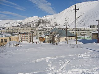
Kirovsk, known as Khibinogorsk (Хибиного́рск) until 1934, is a town in Murmansk Oblast, Russia, located at the spurs of the Khibiny Mountains on the shores of the Lake Bolshoy Vudyavr, 175 kilometers (109 mi) south of Murmansk. Population: 28,625 (2010 Census).
Polyarnye Zori is a town in Murmansk Oblast, Russia, located on the Niva River, Lake Imandra, and Lake Pinozero, 224 kilometers (139 mi) south of Murmansk. The nearest settlements to Polyarnye Zory are: Zasheek (3 km), Pinozero (4 km), Nivskiy (8 km) and Afrikanda-1,2. Population : 14,196, 15,096 (2010 Census); 15,910 (2002 Census); 19,428 (1989 Soviet census).
Lovozersky District is an administrative district (raion), one of the six in Murmansk Oblast, Russia. Municipally, it is incorporated as Lovozersky Municipal District. It occupies most of the central and northeastern parts of the Kola Peninsula. The area of the district is 53,800 square kilometers (20,800 sq mi). Its administrative center is the rural locality of Lovozero. District's population: 11,820 (2010 Census); 14,311 (2002 Census); 18,263 (1989 Soviet census). The population of Lovozero accounts for 24.3% of the district's total population.
Zasheyek is a rural locality in administrative jurisdiction of Polyarnye Zori Town with Jurisdictional Territory in Murmansk Oblast, Russia, located beyond the Arctic Circle on the Kola Peninsula at a height of 142 meters (466 ft) above sea level. Population: 901.
Luvenga is a rural locality in Kandalakshsky District of Murmansk Oblast, Russia, located beyond the Arctic Circle at a height of 30 meters (98 ft) above sea level. Population: 575 .Dysaphis karyakini was first found in this region
Fedoseyevka is a rural locality in Kandalakshsky District of Murmansk Oblast, Russia, located beyond the Arctic Circle at a height of 1 meter above sea level. Population: 3.
Beloye More is a rural locality in Kandalakshsky District of Murmansk Oblast, Russia, located beyond the Arctic Circle at a height of 17 meters (56 ft) above sea level. Population: 660.
Pinozero is a rural locality in Kandalakshsky District of Murmansk Oblast, Russia, located beyond the Arctic Circle at a height of 105 meters (344 ft) above sea level. Population: 149.
Prolivy is a rural locality in Kandalakshsky District of Murmansk Oblast, Russia, located beyond the Arctic Circle at a height of 19 meters (62 ft) above sea level. Population: 42.
Kovda is a rural locality in Kandalakshsky District of Murmansk Oblast, Russia, located beyond the Arctic Circle at a height of 18 meters (59 ft) above sea level. Population: 20.
Lesozavodsky is a rural locality in Kandalakshsky District of Murmansk Oblast, Russia, located beyond the Arctic Circle at a height of 1 meter above sea level. Population: 391.
Kovda is a rural locality in Kandalakshsky District of Murmansk Oblast, Russia, located beyond the Arctic Circle at a height of 18 meters (59 ft) above sea level. Population: 37.
Zhemchuzhnaya is a rural locality in Kandalakshsky District of Murmansk Oblast, Russia, located beyond the Arctic Circle. Population: 2.
Zarechensk is a rural locality in Kandalakshsky District of Murmansk Oblast, Russia, located beyond the Arctic Circle at a height of 124 meters (407 ft) above sea level. Population: 621.
Alakurtti is a rural locality in Kandalakshsky District of Murmansk Oblast, Russia, located north of the Arctic Circle at an altitude of 192 meters (630 ft) above sea level. Its population at the 2010 Census was 3,424. Before 1953 it was part of the Karelo-Finnish Soviet Socialist Republic.
Kuoloyarvi is a rural locality in Kandalakshsky District of Murmansk Oblast, Russia, located north of the Arctic Circle at an altitude of 191 meters (627 ft) above sea level. It had no recorded population as of the 2010 Census.
Priozerny is a rural locality in Kandalakshsky District of Murmansk Oblast, Russia, located beyond the Arctic Circle at a height of 56 meters (184 ft) above sea level. Population: 0.