Kantishna, Alaska

Last updated

Kantishna, Alaska
Kantishna, Alaska.jpg
Kantishna
KantishnaRegion.png
USA Alaska location map.svg
Red pog.svg
Kantishna
Coordinates: 63°31′31″N150°57′29″W / 63.52528°N 150.95806°W / 63.52528; -150.95806
Country United States
State Alaska
Borough Denali
Government
  Borough mayor Clay Walker [1]
   State senator Click Bishop (R)
   State rep. Dave Talerico (R)
Elevation
1,696 ft (517 m)
Time zone UTC-9 (Alaska (AKST))
  Summer (DST) UTC-8 (AKDT)
ZIP codes
Kantishna is one of the sparsely-populated communities in Alaska that do not have a zip code.
GNIS feature ID1404435 [2]

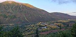
Kantishna is an unincorporated community in Denali Borough, Alaska, United States, within Denali National Park and Preserve. [3] Founded as a gold mining camp in 1905, it endured longer than similar communities in the area, having been constructed nearest to the source of the gold. It lies in the Kantishna Hills at the junction of Eureka Creek and Moose Creek, 3 mi (5 km) northwest of Wonder Lake, and near the mouth of the Kantishna River. Although the community was once also called "Eureka", the Board on Geographic Names officially ruled in favor of "Kantishna" in 1944, the name given to the post office that was built at the site in 1905. Its elevation is 1,696 feet (517 m). [2]

Contents

Transportation and lodging

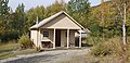
There are several remote lodges in Kantishna. Guests may stay at the Denali Backcountry Lodge, Kantishna Roadhouse, or Camp Denali/North Face Lodge. The 92.5-mile (148.9 km) trip from the Denali Park Train Depot to the lodges, via lodge buses, takes more than six hours. [4] Private vehicles are not permitted to enter the interior of Denali National Park.

Kantishna Air Taxi service provides chartered flights to Kantishna Airport.

Geology

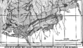
Several thousand prospectors came to the Kantishna Hills region after placer gold was discovered in the summer of 1905 along Glacier Creek by Joe Quigley and Jack Horn. Almost simultaneously, Joe Dalton and his partner Stiles found gold along Friday Creek and staked a claim on July 12. Claims on Eureka Creek soon followed as did mining towns. These included Glacier on Bearpaw River, Diamond on Moose Creek, plus Roosevelt and Square Deal on McKinley River. By 1906 the towns of Roosevelt, Square Deal and Diamond were mainly deserted. In 1916, the population of the region was 35, half of whom were men working claims. [5] [6]

The placer gold originates from the Birch Creek schist, which is cut by quartz veins bearing gold, silver, and antimony in the form of stibnite. This schist is the oldest formation in the region and is bordered on the south by the Tonzona Group composed of black slates and argillites, and the Tatina Group composed on black slates, argillites, greywackes, and interbedded limestones and cherts. [5]

Mining ceased in 1985, after the district was incorporated into the national park. [7] :79

Quigley Ridge

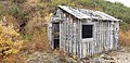
The ridge between Eureka and Friday Creeks became known as Quigley Ridge, after Joe and Fannie Quigley prospected the area. They filed hard rock claims along this ridge, starting with the Silver Pick Claim in Nov. 1910, while Fannie filed placer claims on Friday and Eureka Creeks, and maintained their claims on Glacier Creek. Fannie acquired the Little Annie Claim in Jan. 1914. The main tunnel of Little Annie intersected a 3–4 foot thick quartz vein 90 feet from the entrance, which outcropped in an open-cut in the above hillside. A 42 foot drift followed the vein. By 1921, Joe Quigley was developing the Red Top Lode, using a 40 foot shaft and a 200 foot drift to follow a vein. Eventually, the mine included 500 feet of tunnel. Ernest R. Fransen and Clifton M. Hawkins then purchased 17 Quigley claims, from which Joe and Fannie received $100,000, and 10% of gross. Fransen and Hawkins formed the Red Top Mining Company, with A. Hjalmer Nordale, which operated from 1935 until 1942, when WWII suspended gold mining. Company operations included a 5 mile access road, an assay shop, bunkhouses, and a blacksmith shop. The ridge also became the site of the Quigley homestead and cabin, from about 1913 until 1939. By then, Joe and Fannie had separated, and Fannie moved closer to the Kantishna airstrip along Moose Creek. [7]

Related Research Articles

<span class="mw-page-title-main">Denali</span> Highest mountain in North America

Denali is the highest mountain peak in North America, with a summit elevation of 20,310 feet (6,190 m) above sea level. It is the tallest mountain in the world from base-to-peak on land, measuring 18,000 ft (5,500 m), and Earth's highest mountain north of 43°N. With a topographic prominence of 20,194 feet (6,155 m) and a topographic isolation of 4,621.1 miles (7,436.9 km), Denali is the third most prominent and third-most isolated peak on Earth, after Mount Everest and Aconcagua. Located in the Alaska Range in the interior of the U.S. state of Alaska, Denali is the centerpiece of Denali National Park and Preserve.

<span class="mw-page-title-main">Denali National Park and Preserve</span> National park in Alaska, US

Denali National Park and Preserve, formerly known as Mount McKinley National Park, is a national park and preserve located in Interior Alaska, United States, centered on Denali, the highest mountain in North America. The park and contiguous preserve encompass 6,045,153 acres which is larger than the state of New Hampshire. On December 2, 1980, 2,146,580-acre Denali Wilderness was established within the park. Denali's landscape is a mix of forest at the lowest elevations, including deciduous taiga, with tundra at middle elevations, and glaciers, snow, and bare rock at the highest elevations. The longest glacier is the Kahiltna Glacier. Wintertime activities include dog sledding, cross-country skiing, and snowmobiling. The park received 594,660 recreational visitors in 2018.

<span class="mw-page-title-main">Katmai National Park and Preserve</span> National park in Alaska, United States

Katmai National Park and Preserve is an American national park and preserve in southwest Alaska, notable for the Valley of Ten Thousand Smokes and for its brown bears. The park and preserve encompass 4,093,077 acres, which is between the sizes of Connecticut and New Jersey. Most of the national park is a designated wilderness area. The park is named after Mount Katmai, its centerpiece stratovolcano. The park is located on the Alaska Peninsula, across from Kodiak Island, with headquarters in nearby King Salmon, about 290 miles (470 km) southwest of Anchorage. The area was first designated a national monument in 1918 to protect the area around the major 1912 volcanic eruption of Novarupta, which formed the Valley of Ten Thousand Smokes, a 40-square-mile (100 km2), 100-to-700-foot-deep pyroclastic flow. The park includes as many as 18 individual volcanoes, seven of which have been active since 1900.

<span class="mw-page-title-main">Glacier Bay National Park and Preserve</span> National park in Alaska, United States

Glacier Bay National Park and Preserve is an American national park located in Southeast Alaska west of Juneau. President Calvin Coolidge proclaimed the area around Glacier Bay a national monument under the Antiquities Act on February 26, 1925. Subsequent to an expansion of the monument by President Jimmy Carter in 1978, the Alaska National Interest Lands Conservation Act (ANILCA) enlarged the national monument by 523,000 acres on December 2, 1980, and created Glacier Bay National Park and Preserve. The national preserve encompasses 58,406 acres of public land to the immediate northwest of the park, protecting a portion of the Alsek River with its fish and wildlife habitats, while allowing sport hunting.

<span class="mw-page-title-main">Denali State Park</span> State park in Alaska, United States

Denali State Park is a 325,240-acre (131,620 ha) state park in the U.S. state of Alaska. It is located in the Matanuska-Susitna Borough adjacent to the east side of Denali National Park and Preserve, along the Parks Highway.

<span class="mw-page-title-main">Hatcher Pass</span>

Hatcher Pass is a mountain pass through the southwest part of the Talkeetna Mountains, Alaska. It is named after Robert Hatcher, a prospector and miner. The nearest cities are Palmer and Wasilla approximately 12 miles (19 km) to the south, and Willow approximately 26 mi (42 km) to the west. The communities are at an elevation of approximately 250 ft (76 m) in the Mat-Su valley.

<span class="mw-page-title-main">Denali Highway</span> Highway in Alaska, USA

Denali Highway is a lightly traveled, mostly gravel highway in the U.S. state of Alaska. It leads from Paxson on the Richardson Highway to Cantwell on the Parks Highway. Opened in 1957, it was the first road access to Denali National Park. Since 1971, primary park access has been via the Parks Highway, which incorporated a section of the Denali Highway from Cantwell to the present-day park entrance. The Denali Highway is 135 miles (217 km) in length.

The Stampede Trail is a remote road and trail located in the Denali Borough in the U.S. state of Alaska. Apart from a paved or maintained gravel road for 8 miles (13 km) between Eight Mile Lake and the trail's eastern end, the route consists of a primitive and at times dangerous hiking or ATV trail following the path of the original road, which has deteriorated over the years. The route ends at an abandoned antimony mine at 63.740739°N 150.379229°W along Stampede Creek, a couple miles past Stampede Airport's grass airstrip.

<span class="mw-page-title-main">Kantishna River</span> River in Alaska, United States

The Kantishna River is a 108-mile (174 km) tributary of the Tanana River in the U.S. state of Alaska. Formed by the confluence of the McKinley River with Birch Creek in Denali National Park and Preserve, it drains part of the north slope of the Alaska Range including the Denali massif. The direction of flow is generally north-northeast. The Toklat River is a major tributary.

<span class="mw-page-title-main">Doyon, Limited</span> Oil services company

Doyon, Limited, is one of thirteen Alaska Native Regional Corporations created under the Alaska Native Claims Settlement Act of 1971 (ANCSA) in settlement of aboriginal land claims. Doyon was incorporated in Alaska on June 26, 1972. Headquartered in Fairbanks, Alaska, Doyon is a for-profit corporation with about 18,000 Alaska Native shareholders primarily of Alaskan Athabaskan descent.

<span class="mw-page-title-main">Harry Karstens</span>

Henry Peter Karstens was the first superintendent of Denali National Park, from 1921 to 1928. He was the guide and climbing leader of the first complete ascent of Denali in 1913, with expedition members Hudson Stuck, Walter Harper and Robert Tatum. John Fredson and Esaias George were two young Gwich'in Alaska Natives who supported the party.

Gold mining in Alaska, a state of the United States, has been a major industry and impetus for exploration and settlement since a few years after the United States acquired the territory in 1867 from the Russian Empire. Russian explorers discovered placer gold in the Kenai River in 1848, but no gold was produced. Gold mining started in 1870 from placers southeast of Juneau, Alaska.

The Willow Creek mining district, also known as the Independence Mine/Hatcher Pass district, is a gold-mining area in the U.S. state of Alaska. Underground hard-rock mining of gold from quartz veins accounts for most of the mineral wealth extracted from the Hatcher Pass area. The first mining efforts were placer mining of stream gravels, and placer mining in the area has continued sporadically to this day. Robert Hatcher discovered gold and staked the first claim in the Willow Creek valley in September 1906. The first lode mill in the area started operating in 1908. Underground mining continued at a variety of locations around the pass until 1951. In the 1980s one of the area's hard-rock mines was briefly re-opened. At least one mining company is actively exploring for gold in the area now. Through 2006 the district produced 667-thousand ounces of hard rock gold and 60-thousand ounces of placer gold.

<span class="mw-page-title-main">Alaska–St. Elias Range tundra</span> Tundra ecoregion of Canada and the United States

The Alaska–St. Elias Range tundra is an ecoregion of northwestern North America.

<i>Gold Rush</i> (TV series) American reality television series

Gold Rush is a reality television series that airs on Discovery and its affiliates worldwide. The series follows the placer gold mining efforts of various family-run mining companies, mostly in the Klondike region of Dawson City, Yukon, Canada, as well as in the U.S. state of Alaska. In its 12th season as of early 2021, prior seasons also included mining efforts in South America and western North America.

<span class="mw-page-title-main">Juneau gold belt</span> Juneau gold belt buried deep underground mystery

The Juneau gold belt is located in the southeastern portion of the U.S. state of Alaska. This belt is approximately 100 miles (160 km) in length, north/northwest-trending, and extends from Berners Bay southeastward to Windham Bay, 60 miles (97 km) southeast of Juneau, and includes Douglas Island. The belt contains over 200 gold-quartz-vein deposits with production nearing 7,000,000 ounces (200,000,000 g) of gold. More than three-quarters of Alaska's lode gold was mined from the Juneau gold belt.

Mount Capps is a 10,551-foot (3,216 m) mountain in the Alaska Range, in Denali National Park and Preserve, southwest of Denali on a ridge between Denali and Mount Crosson, close to Kahiltna Dome and at the heads of Peters Glacier and Kahiltna Glacier. Mount Capps was named in 1952 by after U.S. Geological Survey geologist Stephen Reid Capps.

<span class="mw-page-title-main">Mount Tatum</span> Mountain in Alaska, U.S.

Mount Tatum is an 11,140-foot (3,395 m) mountain summit in the Alaska Range, in Denali National Park and Preserve. Mount Tatum lies to the northeast of Denali on Carpe Ridge with Muldrow Glacier to the west and Traleika Glacier to the east. Mount Tatum was named about 1945 by Bradford Washburn for Robert G. Tatum, a participant in the first ascent of Mount McKinley, reaching the South Peak on June 1, 1913.

<span class="mw-page-title-main">Mount Johnson (Alaska)</span> Mountain in the American state of Alaska

Mount Johnson is an 8,400+ ft mountain summit located in the Alaska Range, in Denali National Park and Preserve, in Alaska, United States. It is situated on the west side of the Ruth Gorge, 15 mi (24 km) southeast of Denali and 6 mi (10 km) south-southwest of The Moose's Tooth. Its nearest higher peak is Mount Wake, 0.69 miles (1.11 km) to the northwest.

<span class="mw-page-title-main">Fannie Quigley</span> Alaskan pioneer and prospector (1870–1944)

Fannie Quigley was an American pioneer and prospector and cook who became involved in mining operations during the Klondike Gold Rush. Living in the wilderness of what is now Denali National Park and Preserve in Alaska, she was known for her hunting, trapping, and cooking skills.

References

  1. 2015 Alaska Municipal Officials Directory. Juneau: Alaska Municipal League. 2015. p. 5.
  2. 1 2 "Kantishna, Alaska". Geographic Names Information System . United States Geological Survey, United States Department of the Interior.
  3. AK: Best of Summer, Alaska Public Radio, September 13, 2008. Accessed 2008-09-13.
  4. "Scenic Alaskan Bus Tours through Denali Park to Kantishna". Doyon Tourism, Inc. Retrieved July 22, 2012.
  5. 1 2 Capps, Stephen (1917). Mineral Resources of the Kantishna Region (USGS Bulletin 662 ed.). Washington: US Government Printing Office. pp. 279–331.
  6. Capps, Stephen (1919). The Kantishna Region, Alaska, USGS Bulletin 687. Washington: Government Printing Office. Retrieved September 12, 2019.
  7. 1 2 Haigh, Jane (2007). Searching for Fannie Quigley: A Wilderness Life in the Shadow of Mount McKinley. Athens: Swallow Press. pp. 60, 75, 80–81, 92–93, 143–148. ISBN   9780804010979.