Suntrana, Alaska

Last updated

Suntrana, Alaska
Ghost town
Usibelli Mine plant, Suntrana Alaska, 1950s.jpg
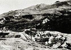
Mine plant and Alaska Railroad tracks, mid 1950s.
USA Alaska location map.svg
Red pog.svg
Suntrana
Location within the state of Alaska
Coordinates: 63°51′15″N148°50′54″W / 63.85417°N 148.84833°W / 63.85417; -148.84833
Country United States
State Alaska
Borough Denali
Government
  Borough mayor Clay Walker [1]
   State senator Click Bishop (R)
   State rep. Dave Talerico (R)
Elevation
1,463 ft (446 m)
Time zone UTC-9 (Alaska (AKST))
  Summer (DST) UTC-8 (AKDT)
GNIS feature ID1410410 [2]

Suntrana was an unincorporated community in eastern Denali Borough, Alaska, United States. It is located within the census-designated place of Healy.

It lies off the George Parks Highway south of the city of Anderson, and on the northeastern edge of Denali National Park and Preserve. [3] Its elevation is 1,463 feet (446 m). Located along the right bank of the Healy River, Suntrana lies 3½ miles (5½ km) east of Healy, the borough seat of the Denali Borough.

The town and mine at Suntrana no longer exist, the site of company housing is now mostly reforested, and little of the mine, power house or old tipple complex remains.

Demographics

Historical population
CensusPop.Note
1930 61
1940 7827.9%
1950 13066.7%
1960 81−37.7%
1970 67−17.3%
1980 56−16.4%
U.S. Decennial Census [4]

Suntrana first appeared on the 1940 U.S. Census as an unincorporated village. In 1980, it was made a census-designated place (CDP). In 1990, the CDP was dissolved and was attached to Healy CDP.

Related Research Articles

<span class="mw-page-title-main">Denali Borough, Alaska</span> Borough in Alaska, United States

The Denali Borough is a borough located in the U.S. state of Alaska. As of the 2020 census the population of the borough was 1,619, down from 1,826 in 2010. The borough seat and most populated community is Healy, and its only incorporated place is Anderson. The borough was incorporated in December 1990.

<span class="mw-page-title-main">Southeast Fairbanks Census Area, Alaska</span> Census area in Alaska, United States

Southeast Fairbanks Census Area is a census area located in the U.S. state of Alaska. As of the 2020 census, the population was 6,808, down from 7,029 in 2010. It is part of the unorganized borough and therefore has no borough seat. Its largest communities are Deltana and Tok, both unincorporated CDPs.

<span class="mw-page-title-main">Anderson, Alaska</span> City in Alaska, United States

Anderson is a city in the Denali Borough, Alaska, United States, and the borough's only incorporated community. At the 2010 census the population was 246, down from 367 at the 2000 census. At the 2020 census, the population dropped to 177 residents. The city is named after one of the original homesteaders.

<span class="mw-page-title-main">Cantwell, Alaska</span> Census-designated place in Alaska, United States

Cantwell is a census-designated place (CDP) in Denali Borough, Alaska, United States. As of the 2020 census, the population of the CDP was 200.

<span class="mw-page-title-main">Ferry, Alaska</span> Census-designated place in Alaska, United States

Ferry is a census-designated place (CDP) in Denali Borough, Alaska, United States. The population was 17 at the 2020 census, down from 33 in 2010.

<span class="mw-page-title-main">Healy, Alaska</span> Census-designated place in Alaska, United States

Healy is a census-designated place (CDP) and the borough seat of Denali Borough in the U.S. state of Alaska. The population was 966 at the time of the 2020 census, down from 1,021 in 2010.

<span class="mw-page-title-main">Denali Park (CDP), Alaska</span> Census-designated place in Alaska, United States

Denali Park, formerly McKinley Park, is a census-designated place (CDP) in Denali Borough, in the U.S. state of Alaska. As of the 2020 census, the population of the CDP was 163, down from 185 at the 2010 census.

<span class="mw-page-title-main">Karluk, Alaska</span> Census-designated place in Alaska, United States

Karluk is a census-designated place (CDP) in Kodiak Borough, Kodiak Island, Alaska, United States. The population was 37 at the 2010 census, up from 27 in 2000.

<span class="mw-page-title-main">Port Alsworth, Alaska</span> Census-designated place in Alaska, United States

Port Alsworth is a census-designated place (CDP) in Lake and Peninsula Borough, Alaska, United States. It is 165 miles (266 km) by air southwest of Anchorage. The population was 186 at the 2020 census, up from 159 in 2010. It is the most populated community in the borough.

<span class="mw-page-title-main">Petersville, Alaska</span> Census-designated place in Alaska, United States

Petersville is a census-designated place (CDP) in Matanuska-Susitna Borough, Alaska, United States. It is part of the Anchorage Metropolitan Area. The population was 27 at the 2020 census.

<span class="mw-page-title-main">Talkeetna, Alaska</span> CDP in Alaska, United States

Talkeetna is a census-designated place (CDP) in Matanuska-Susitna Borough, Alaska, United States. At the 2020 census the population was 1,055, up from 876 in 2010.

<span class="mw-page-title-main">Trapper Creek, Alaska</span> Census-designated place in Alaska, United States

Trapper Creek is a census-designated place (CDP) in Matanuska-Susitna Borough, Alaska, United States. It is part of the Anchorage Metropolitan Area and is known as the southern gateway to Denali State Park. According to the 2020 census the population of Trapper Creek was 499.

<span class="mw-page-title-main">Healy Lake, Alaska</span> CDP in Alaska, United States

Healy Lake is a census-designated place (CDP) in Southeast Fairbanks Census Area, Alaska, United States. The population was 13 at the 2010 census, down from 37 in 2000.

<span class="mw-page-title-main">Newcastle, Utah</span> Census-designated place in Utah, United States

Newcastle is an unincorporated community and census-designated place (CDP) in southwestern Iron County, Utah, United States. It lies along State Route 56, 30 miles (48 km) west of Cedar City. Its elevation is 5,312 feet (1,619 m) above sea level. Newcastle has a post office with the ZIP code of 84756. The population was 247 at the 2010 census. Newcastle was founded in 1910 by citizens of the more isolated Pinto.

<span class="mw-page-title-main">Teasdale, Utah</span> Census-designated place in Utah, United States

Teasdale is a census-designated place in western Wayne County, Utah, United States, between the Dixie and Fishlake National Forests and near Capitol Reef National Park. The population was 191 at the 2010 census. Teasdale lies along local roads south of State Route 24, southeast of the town of Loa, the county seat of Wayne County. Teasdale has a post office with the ZIP code 84773.

<span class="mw-page-title-main">Veyo, Utah</span> CDP in Utah, United States

Veyo is a census-designated place in western Washington County, Utah, United States, on the edge of the Dixie National Forest. The population was 483 at the 2010 census. The town lies along State Route 18 north of the city of St. George.

Moscow is an unincorporated community and census-designated place (CDP) in Muscatine County, Iowa, United States. As of the 2020 census, the population was 290. It has a post office, with the ZIP code of 52760, which opened on May 1, 1837. The community is part of the Muscatine Micropolitan Statistical Area.

Nabesna is a census-designated place and unincorporated community in northern Copper River Census Area, Alaska, United States, in the northern part of the Wrangell-St. Elias National Park and Preserve. It lies along the Nabesna Road, a gravel road that connects it to the Tok Cut-Off at Slana. Its elevation is 2,979 feet (908 m). Founded by and named for the Nabesna Mining Company, the community received a post office in 1909. Located at the base of White Mountain in the Wrangell Mountains, it lies west of the Nabesna River. According to the 2020 census, there were two people residing at this location.

Usibelli is an unincorporated community in Denali Borough, Alaska, United States, 5 miles (8 km) east of Healy. Its elevation is 1,654 feet (504 m). The community is named for the Usibelli Coal Mine; located near the community, the mine is the chief economic enterprise in the area. With its large deposits and its status as the only coal mine in the state, Usibelli Coal Mine has long been prominent; it is a primary supplier for coal-fired power plants in the Fairbanks area and in southern Alaska, and it exports coal to South Korea and Chile. In recent years, the mine has stood to benefit from efforts for American energy independence; a bill in the United States Senate in 2008 was amended to encourage conversion of coal into liquid fuels for the use of the United States Air Force.

<span class="mw-page-title-main">National Register of Historic Places listings in Denali Borough, Alaska</span>

This is a list of the National Register of Historic Places listings in Denali Borough, Alaska.

References

  1. 2015 Alaska Municipal Officials Directory. Juneau: Alaska Municipal League. 2015. p. 5.
  2. "Suntrana, Alaska". Geographic Names Information System . United States Geological Survey, United States Department of the Interior.
  3. Rand McNally. The Road Atlas '08. Chicago: Rand McNally, 2008, p. 6.
  4. "U.S. Decennial Census". Census.gov. Retrieved June 6, 2013.