Kapalong Last updated July 19, 2025 Municipality in Davao del Norte, Philippines
Municipality in Davao Region, Philippines
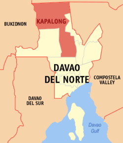
Kapalong , officially the Municipality of Kapalong (Cebuano : Lungsod sa Kapalong Tagalog : Bayan ng Kapalong municipality in the province of Davao del Norte , Philippines . According to the 2020 census, it has a population of 81,068 people. [ 5]
History Through Executive Order No. 151 signed by President Elpidio Quirino , the town was founded on July 8, 1948, [ 6] from the Municipal District of Tagum, which was formed in 1918. It was one of the oldest towns in Davao del Norte Province , others being Tagum , in 1941; and Panabo , in 1949, both of which were converted into cities almost 50 years later. Though the towns of Santo Tomas , Talaingod and portion of San Isidro emerged from Kapalong in 1959, 1991, and 2004 respectively, it is still the largest town by land area in the province of Davao del Norte.
Geography All but one of Kapalongs barangays are located in the southern part of the municipality near the Kapalong-Talaingod-Valencia National Highway. The much more sparsely populated north is administered under Barangay Gupitan covering a land area of 65,000 ha (650 km 2 ) which makes it the largest barangay of the Philippines. [ 7]
Climate Climate data for Kapalong Month Jan Feb Mar Apr May Jun Jul Aug Sep Oct Nov Dec Year Mean daily maximum °C (°F) 28 28 29 31 31 30 30 31 31 31 30 29 30 Mean daily minimum °C (°F) 22 22 22 22 23 24 23 23 23 23 23 23 23 Average precipitation mm (inches) 63 50 35 22 47 68 51 53 49 47 39 38 562 Average rainy days 15.0 12.6 10.4 8.2 18.8 22.5 21.2 20.5 20.3 20.3 14.4 11.7 195.9 Source: Meteoblue [ 8]
Barangays Kapalong is politically subdivided into 14 barangays . Each barangay consists of puroks while some have sitios .
Semong Florida Gabuyan Gupitan Capungagan Katipunan Luna Mabantao Mamacao Pag-asa Maniki (Poblacion) Sampao Sua-on Tiburcia Demographics Population census of Kapalong Year ±% p.a. 1939 5,555 — 1948 5,878 +0.63% 1960 12,067 +6.18% 1970 20,225 +5.29% 1975 33,362 +10.56% 1980 42,869 +5.14% 1990 66,030 +4.42% 1995 62,183 −1.12% 2000 68,593 +2.13% 2007 61,763 −1.44% 2010 68,261 +3.71% 2015 76,334 +2.15% 2020 81,068 +1.27% 2024 80,731 −0.10% Source: Philippine Statistics Authority [ 9] [ 10] [ 11] [ 12] [ 13]
Economy Poverty incidence of Kapalong
References ↑ Municipality of Kapalong | (DILG) ↑ "2015 Census of Population, Report No. 3 – Population, Land Area, and Population Density" (PDF) . Philippine Statistics Authority . Quezon City, Philippines. August 2016. ISSN 0117-1453 . Archived (PDF) from the original on May 25, 2021. Retrieved July 16, 2021 . ↑ "2024 Census of Population (POPCEN) Population Counts Declared Official by the President" . Philippine Statistics Authority. 17 July 2025. Retrieved 18 July 2025 . ↑ "PSA Releases the 2021 City and Municipal Level Poverty Estimates" . Philippine Statistics Authority. 2 April 2024. Retrieved 28 April 2024 . ↑ "2024 Census of Population (POPCEN) Population Counts Declared Official by the President" . Philippine Statistics Authority. 17 July 2025. Retrieved 18 July 2025 . ↑ "Executive Order No. 151, s. 1948" . Official Gazette of the Republic of the Philippines . Archived from the original on June 30, 2019. Retrieved 31 January 2023 . ↑ Duron-Abangan, Jeanevive (2019-05-21). "Military, civilian agencies turn focus on indigenous Manobo tribe" . Reliefweb . Retrieved 2025-05-17 . ↑ "Kapalong: Average Temperatures and Rainfall" . Meteoblue. Retrieved 29 February 2020 . ↑ "2024 Census of Population (POPCEN) Population Counts Declared Official by the President" . Philippine Statistics Authority. 17 July 2025. Retrieved 18 July 2025 . ↑ Census of Population (2015). "Region XI (Davao Region)" . Total Population by Province, City, Municipality and Barangay . Philippine Statistics Authority . Retrieved 20 June 2016 . ↑ Census of Population and Housing (2010). "Region XI (Davao Region)" (PDF) . Total Population by Province, City, Municipality and Barangay . National Statistics Office . Retrieved 29 June 2016 . ↑ Censuses of Population (1903–2007). "Region XI (Davao Region)" . Table 1. Population Enumerated in Various Censuses by Province/Highly Urbanized City: 1903 to 2007 National Statistics Office . ↑ "Province of" . Municipality Population Data . Local Water Utilities Administration Research Division. Retrieved 17 December 2016 . ↑ "Poverty incidence (PI):" . Philippine Statistics Authority. Retrieved December 28, 2020 . ↑ "Estimation of Local Poverty in the Philippines" (PDF) . Philippine Statistics Authority. 29 November 2005. ↑ "2003 City and Municipal Level Poverty Estimates" (PDF) . Philippine Statistics Authority. 23 March 2009. ↑ "City and Municipal Level Poverty Estimates; 2006 and 2009" (PDF) . Philippine Statistics Authority. 3 August 2012. ↑ "2012 Municipal and City Level Poverty Estimates" (PDF) . Philippine Statistics Authority. 31 May 2016. ↑ "Municipal and City Level Small Area Poverty Estimates; 2009, 2012 and 2015" . Philippine Statistics Authority. 10 July 2019. ↑ "PSA Releases the 2018 Municipal and City Level Poverty Estimates" . Philippine Statistics Authority. 15 December 2021. Retrieved 22 January 2022 . ↑ "PSA Releases the 2021 City and Municipal Level Poverty Estimates" . Philippine Statistics Authority. 2 April 2024. Retrieved 28 April 2024 . External links
Places adjacent to Kapalong
This page is based on this
Wikipedia article Text is available under the
CC BY-SA 4.0 license; additional terms may apply.
Images, videos and audio are available under their respective licenses.