{{native name|ru|Копыль}}"},"other_name":{"wt":"Kopyl"},"image_skyline":{"wt":"Kapyl.jpg"},"imagesize":{"wt":"250px"},"image_flag":{"wt":"Flag of Kapyl.svg"},"image_shield":{"wt":"Coat of Arms of Kapyl, Belarus.svg"},"flag_size":{"wt":"150"},"shield_size":{"wt":"75"},"pushpin_map":{"wt":"Belarus"},"pushpin_map_caption":{"wt":"Location in Belarus"},"subdivision_type":{"wt":"Country"},"subdivision_name":{"wt":"[[Belarus]]"},"subdivision_type1":{"wt":"[[Regions of Belarus|Region]]"},"subdivision_name1":{"wt":"[[Minsk Region]]"},"subdivision_type2":{"wt":"[[Districts of Belarus|District]]"},"subdivision_name2":{"wt":"[[Kapyl District]]"},"leader_title":{"wt":""},"leader_name":{"wt":""},"established_title":{"wt":"First mentioned"},"established_date":{"wt":"1274"},"area_magnitude":{"wt":""},"area_total_km2":{"wt":""},"area_land_km2":{"wt":""},"area_water_km2":{"wt":""},"population_as_of":{"wt":"2024"},"population_note":{"wt":""},"population_total":{"wt":"9,985"},"population_footnotes":{"wt":"{{cite web|url=https://www.belstat.gov.by/ofitsialnaya-statistika/solialnaya-sfera/naselenie-i-migratsiya/naselenie/statisticheskie-izdaniya/index_89355/|title=Численность населения на 1 января 2024 г. и среднегодовая численность населения за 2023 год по Республике Беларусь в разрезе областей, районов, городов, поселков городского типа|archive-url=https://web.archive.org/web/20240402055418/https://www.belstat.gov.by/ofitsialnaya-statistika/solialnaya-sfera/naselenie-i-migratsiya/naselenie/statisticheskie-izdaniya/index_89355/|archive-date=2 April 2024|website=belsat.gov.by|access-date=9 April 2024}}"},"population_metro":{"wt":""},"population_density_km2":{"wt":""},"timezone":{"wt":"[[Moscow Time|MSK]]"},"utc_offset":{"wt":"+3"},"timezone_DST":{"wt":""},"utc_offset_DST":{"wt":""},"coordinates":{"wt":"{{coord|53|09|0|N|27|05|30|E|region:BY|display=inline,title}}"},"elevation_m":{"wt":""},"postal_code_type":{"wt":"Postal code"},"postal_code":{"wt":"223 910, 223 927[http://www.minsk-region.gov.by/index.aspx?id=23] {{Webarchive|url=https://web.archive.org/web/20120227191533/http://www.minsk-region.gov.by/index.aspx?id=23 |date=2012-02-27 }} Kopyl raion page at Minsk [[Oblispolkom]] website accessed 13 July 2010"},"area_code":{"wt":"+375 1719"},"blank_name":{"wt":"License plate"},"blank_info":{"wt":"5"},"website":{"wt":""},"footnotes":{"wt":""}},"i":0}}]}" id="mwBA">Town in Minsk Region, Belarus
Kapyl Kopyl | |
---|---|
![]() | |
Coordinates: 53°09′0″N27°05′30″E / 53.15000°N 27.09167°E | |
Country | Belarus |
Region | Minsk Region |
District | Kapyl District |
First mentioned | 1274 |
Population (2024) [1] | |
• Total | 9,985 |
Time zone | UTC+3 (MSK) |
Postal code | 223 910, 223 927 [2] |
Area code | +375 1719 |
License plate | 5 |
Kapyl (Belarusian : Капыль, romanized: Kapyĺ; Russian : Копыль, romanized: Kopyl; Polish : Kopyl; Lithuanian : Kapylius; Yiddish : קאפּוליע) is a town in Minsk Region, Belarus. It serves as the administrative center of Kapyl District. [1] It is located 34 kilometers (21 mi) west-northwest of Slutsk and 90 kilometers (56 mi) south-southwest of the capital Minsk. [3] In 2009, its estimated population was 9,900 based on the provisional figures from the 2009 census. [4] As of 2024, it has a population of 9,985. [1]
Kapyl, first mentioned in 1274, [5] was a walled town that was noteworthy by the 14th century, and is listed in the atlas of Ortelius of 1574. [6] During the 14th century the town was part of the Grand Duchy of Lithuania. In 1395 it came into the possession of Prince Vladimir Olgerdovich and his heirs, the Olelkovich family, where it remained until 1612. Kapyl was part of the dowry of Zofia Olelkowicz Słucka and was one of the seven fortified towns left to her husband Janusz Radziwill upon her death in 1612. [6] Kapyl was attacked by the Tatars numerous times and was sacked on at least one occasion during the 16th century. [6]
On August 27, 1652, Kapyl received the Magdeburg Law and gained its own seal, a coat of arms depicting a hunting horn on a gold field. With this privilege came the right to hold fairs and weekly auctions. During the 16th century weaving became established in the town, including the production of velvet. Six guilds came into existence as a result of the growth of the weaving industry.
After the Second Partition of Poland in 1793 Kapyl became part of the Russian Empire. From 1832 it became a personal holding of Prince Wittgenstein. During the 19th century local businesses included a brewery, 2 water mills, and 6 shops. Other local institutions included 3 schools, churches (including a Calvinist church), and 2 Jewish synagogues.
Towards the end of the 19th century Kapyl had over 350 houses and over 2000 inhabitants. At that time a majority of the town's population was Jewish. [6] By 1900 the Jewish population was 2,671. [3]
In 1924, Kapyl became the capital city of the Kapyl District.
During World War II the Slutsk-Kapyl area was the subject of a German military operation code-named Erntefest II (Harvest Festival) which ended in February 1943. Although ostensibly aimed at suppressing the activities of Soviet partisans in the area the operation resulted in the deaths of 2,325 of the local inhabitants (against the loss of six German soldiers), which can only be characterized as a campaign of genocide and terror. [7]
One of Kapyl district's major architectural monuments is a 19th-century church in the town itself. [8]
Minsk Region, also known as Minsk Oblast or Minsk Voblasts, is one of the six regions of Belarus. Its administrative center is Minsk, although it is a separate administrative territorial entity of Belarus. The region's population was recorded at 1,411,500 in 2011.
Slutsk is a town in Minsk Region, Belarus. It serves as the administrative center of Slutsk District, and is located on the Sluch River 105 km (65 mi) south of the capital Minsk. As of 2024, it has a population of 60,056.
Valozhyn or Volozhin is a town in Minsk Region, Belarus. It serves as the administrative center of Valozhyn District. It is located 75 km (47 mi) northwest of the capital Minsk, on the Valozhynka River in the Neman River basin, and the beginning of the Naliboki forest. In 1995, its population was approximately 11,500. As of 2024, it has a population of 10,015.
Nyasvizh or Nesvizh is a town in Minsk Region, Belarus. It serves as the administrative centre of Nyasvizh District. Nyasvizh is the site of Nesvizh Castle, a World Heritage Site. In 2009, its population was 14,300. As of 2024, it has a population of 15,968.
Zaslawye or Zaslavl is a town in Minsk District, Minsk Region, Belarus. It is located 20 kilometres (12 mi) northwest of the capital Minsk. In 2009, its population was 14,400. As of 2024, it has a population of 17,404.
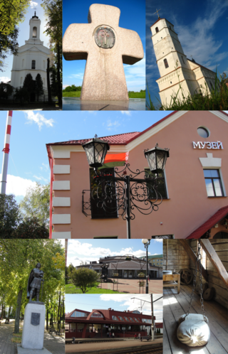
Vileyka or Vilyeyka is a town in Minsk Region, Belarus. It serves as the administrative center of Vileyka District. It is located on the Viliya River, 100 kilometres (62 mi) northwest of Minsk. The first historical record dates from 16 November 1460. As of 2024, the town has a population of 26,625.
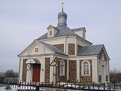
Klyetsk or Kletsk is a town in Minsk Region, Belarus. It serves as the administrative center of Klyetsk District. Klyetsk is located on the Lan River. As of 2024, it has a population of 11,248.
Pyetrykaw or Petrikov is a town in Gomel Region, Belarus. It serves as the administrative center of Pyetrykaw District. At the 2009 census, its population was 10,591. As of 2024, it has a population of 10,401.
Krupki is a town in Minsk Region, Belarus. It serves as the administrative center of Krupki District.
Dzyatlava or Dyatlovo is a town in Grodno Region, Belarus. It serves as the administrative center of Dzyatlava District. It is located about 165 kilometres (103 mi) southeast of Grodno. The population was 7,700 in 2016. As of 2024, it has a population of 7,767.
Chervyen District or Červień District is a district (raion) of Minsk Region in Belarus. Its administrative center is Chervyen. As of 2024, it has a population of 33,401.
Kapyl District or Kapyĺ District is a district (raion) of Minsk Region in Belarus. Its administrative center is Kapyl. As of 2024, it has a population of 26,533.
Klyetsk District or Klieck District is a district (raion) of Minsk Region in Belarus. Its administrative center is the town of Klyetsk. As of 2024, it has a population of 25,611.
Krupki District is a district (raion) of Minsk Region in Belarus. Its administrative center is the town of Krupki. Also located in the district are the urban-type settlements of Bobr and Khalopyenichy. As of 2024, it has a population of 21,723.
Lahoysk District or Lahojsk District is a district (raion) of Minsk Region in Belarus. Its administrative center is the city of Lahoysk. As of 2024, it has a population of 38,519.
Myadzyel District or Miadziel District is a district (raion) of Minsk Region in Belarus. Its administrative center is the town of Myadzyel. As of 2024, it has a population of 24,326.
Smalyavichy District or Smaliavičy District is a district (raion) of Minsk Region in Belarus. Its administrative center is the town of Smalyavichy. The town of Zhodzina is administratively separated from the district. As of 2024, it has a population of 55,439.
Lyuban is a town in Minsk Region, Belarus. It serves as the administrative center of Lyuban District. In 2009, its population was 11,256. As of 2024, it has a population of 11,339.
Surazh is an urban-type settlement in Vitebsk District, Vitebsk Region, Belarus. It is located approximately 45 kilometres (28 mi) northeast from the city of Vitebsk. It is situated at the crossing of the Daugava and Kasplya rivers. As of 2024, it has a population of 672.