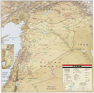
Syria is located in West Asia, north of the Arabian Peninsula, at the eastern end of the Mediterranean Sea. It is bordered by Turkey to the north, Lebanon and Israel to the west and southwest, Iraq to the east, and Jordan to the south. It consists of mountain ranges in the west and a steep area inland. In the east is the Syrian Desert and in the south is the Jabal al-Druze Range. The former is bisected by the Euphrates valley. A dam built in 1973 on the Euphrates created a reservoir named Lake Assad, the largest lake in Syria. The highest point in Syria is Mount Hermon on the Lebanese border at 2,814 metres or 9,232 feet. Between the humid Mediterranean coast and the arid desert regions lies a semiarid steep zone extending across three-quarters of the country, which receives hot, dry winds blowing across the desert. Syria is extensively depleted, with 28 percent of the land arable, 4 percent dedicated to permanent crops, 46 percent utilized as meadows and pastures, and only 3 percent forest and woodland.

Einkorn wheat can refer either to a wild species of wheat (Triticum) or to its domesticated form. The wild form is T. boeoticum, and the domesticated form is T. monococcum. Einkorn is a diploid species of hulled wheat, with tough glumes ('husks') that tightly enclose the grains. The cultivated form is similar to the wild, except that the ear stays intact when ripe and the seeds are larger. The domestic form is known as "petit épeautre" in French, "Einkorn" in German, "einkorn" or "littlespelt" in English, "piccolo farro" in Italian and "escanda menor" in Spanish. The name refers to the fact that each spikelet contains only one grain.

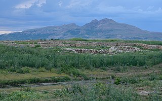
Göbekli Tepe is a Neolithic archaeological site in the Southeastern Anatolia Region of Turkey. The settlement was inhabited from c. 9500 to at least 8000 BCE, during the Pre-Pottery Neolithic. It is famous for its large circular structures that contain massive stone pillars—the world's oldest known megaliths. Many of these pillars are decorated with anthropomorphic details, clothing, and sculptural reliefs of wild animals, providing archaeologists rare insights into prehistoric religion and the particular iconography of the period. The 15 m (50 ft)-high, 8 ha (20-acre) tell is densely covered with ancient domestic structures and other small buildings, quarries, and stone-cut cisterns from the Neolithic, as well as some traces of activity from later periods.
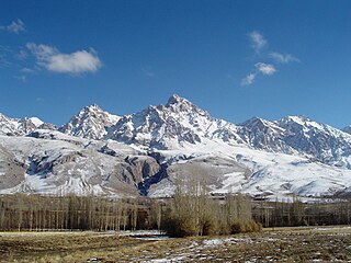
The Taurus Mountains are a mountain complex in southern Turkey, separating the Mediterranean coastal region from the central Anatolian Plateau. The system extends along a curve from Lake Eğirdir in the west to the upper reaches of the Euphrates and Tigris rivers in the east. It is a part of the Alpide belt in Eurasia.
Şanlıurfa Province, also known as Urfa Province, is a province and metropolitan municipality in southeastern Turkey. The city of Şanlıurfa is the capital of the province which bears its name. Its area is 19,242 km2, and its population is 2,170,110 (2022). The province is considered part of Turkish Kurdistan and has a Kurdish majority with a significant Arab and Turkish minority.

The Balikh River is a perennial river that originates in the spring of Ain al-Arous near Tell Abyad in the Eastern Mediterranean conifer-sclerophyllous-broadleaf forests ecoregion. It flows due south and joins the Euphrates at the modern city of Raqqa. The Balikh is the second largest tributary to the Euphrates in Syria, after the Khabur River. It is an important source of water and large sections have recently been subjected to canalization.

Upper Mesopotamia constitutes the uplands and great outwash plain of northwestern Iraq, northeastern Syria and southeastern Turkey, in the northern Middle East. Since the early Muslim conquests of the mid-7th century, the region has been known by the traditional Arabic name of al-Jazira and the Syriac variant Gāzartā or Gozarto (ܓܙܪܬܐ). The Euphrates and Tigris rivers transform Mesopotamia into almost an island, as they are joined together at the Shatt al-Arab in the Basra Governorate of Iraq, and their sources in eastern Turkey are in close proximity.

Samsat, formerly Samosata is a small town in the Adıyaman Province of Turkey, situated on the upper Euphrates river. It is the seat of Samsat District. The town is populated by Kurds of the Bezikan tribe.
The Atatürk Dam, originally the Karababa Dam, is the third largest dam in the world and it is a zoned rock-fill dam with a central core on the Euphrates River on the border of Adıyaman Province and Şanlıurfa Province in the Southeastern Anatolia Region of Turkey. Built both to generate electricity and to irrigate the plains in the region, it was renamed in honour of Mustafa Kemal Atatürk (1881–1938), the founder of the Turkish Republic. The construction began in 1983 and was completed in 1990. The dam and the hydroelectric power plant, which went into service after the upfilling of the reservoir was completed in 1992, are operated by the State Hydraulic Works (DSİ). The reservoir created behind the dam, called Atatürk Reservoir, is the third largest in Turkey.

Mount Hasan is a volcano in Anatolia, Turkey. It has two summits, the 3,069 metres (10,069 ft) high eastern Small Hasan Dagi and the 3,253 metres (10,673 ft) high Big Hasan Dagi, and rises about 1 kilometre (0.62 mi) above the surrounding terrain. It consists of various volcanic deposits, including several calderas, and its activity has been related to the presence of several faults in the area and to regional tectonics.
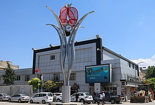
Suruç is a municipality and district of Şanlıurfa Province, Turkey. Its area is 744 km2, and its population is 100,961 (2022). It is on a plain near the Syrian border 46 kilometres (29 mi) southwest of the city of Urfa.
Çayönü Tepesi is a Neolithic settlement in southeastern Turkey which prospered from circa 8,630 to 6,800 BC. It is located in Diyarbakır Province forty kilometres north-west of Diyarbakır, at the foot of the Taurus mountains. It lies near the Boğazçay, a tributary of the upper Tigris River and the Bestakot, an intermittent stream. It is an early example of agriculture.

Ras al-Ayn, also spelled Ras al-Ain, is a city in al-Hasakah Governorate in northeastern Syria, on the Syria–Turkey border.

The Tektek Mountains are a range of mountains located east of Şanlıurfa in southeastern Turkey near the border with Syria.
Lavaş cheese is a distinctive variety of cheese traditionally produced in Karacadağ, in the vicinity of Diyarbakır in Turkey. It is generally made from sheep's milk.
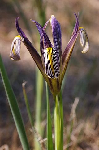
Iris masia, commonly known as the barbed iris, is a species in the genus Iris, it is also in the subgenus Limniris and in the series Syriacae. It is a rhizomatous perennial from the Middle East and Asian Turkey. It has long grass-like leaves, unbranched stems with single flowers in late spring, in shades from purple to violet blue.

Adıyaman Archaeological Museum is an archaeology museum in Adıyaman, southeastern Turkey. It is located at the corner of Atatürk Boulevard and Cumhuriyet Avenue in the heart of the city. The museum displays archaeological finds from the area around the city, as well as from rescue excavations carried out in the course of the Southeastern Anatolia Project.

Sur is a municipality and district of Diyarbakır Province, Turkey. Its area is 1,227 km2, and its population is 100,613 (2022). It covers the eastern part of the city of Diyarbakır and the adjacent countryside. The historical Diyarbakır Fortress lies in this district, which takes its name from the castle walls.
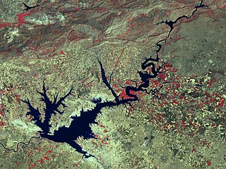
The Atatürk Reservoir is a reservoir on the Euphrates, created by the Atatürk Dam in Turkey. It is located between Adıyaman, Şanlıurfa, and Diyarbakır provinces. The reservoir has a surface area of 817 km² and a volume of 48.5 cubic kilometers, making it the third largest lake in the country after Lake Van and Lake Tuz. It was formed between 1990–1992. The reservoir water level touched 535 m (1,755 ft) amsl in 1994. Since then, it varies between 526 and 537 m amsl. The full reservoir level is 542 m (1,778 ft), and the minimum operation level is 526 m (1,726 ft) amsl.
Dersim Dağ is a politician of the Peoples Democratic Party (HDP) and a member of the Turkish Parliament. She was 22 years of age when elected, and at the time was one of the youngest parliamentarians.


![[6]](./Karaca_Dağ#cite_note-File:Syria_2004_CIA_map.jpg-6)
#/media/File:Khabur_River_in_Syria_2004_CIA_map.jpg)