The Anahim Volcanic Belt (AVB) is a west–east trending chain of volcanoes and related magmatic features in British Columbia, Canada. It extends from Athlone Island on the Central Coast, running eastward through the strongly uplifted and deeply dissected Coast Mountains to near the community of Nazko on the Interior Plateau. The AVB is delineated as three west-to-east segments that differ in age and structure. A wide variety of igneous rocks with differing compositions occur throughout these segments, comprising landforms such as volcanic cones, volcanic plugs, lava domes, shield volcanoes and intrusions.

The Chilcotin Group, also called the Chilcotin Plateau Basalts, is a large area of basaltic lava that forms a volcanic plateau running parallel with the Garibaldi Volcanic Belt in south-central British Columbia, Canada.

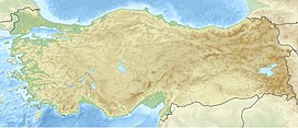
Mount Hasan is a volcano in Anatolia, Turkey. It has two summits, the 3,069 metres (10,069 ft) high eastern Small Hasan Dagi and the 3,253 metres (10,673 ft) high Big Hasan Dagi, and rises about 1 kilometre (0.62 mi) above the surrounding terrain. It consists of various volcanic deposits, including several calderas, and its activity has been related to the presence of several faults in the area and to regional tectonics.

The Northern Cordilleran Volcanic Province (NCVP), formerly known as the Stikine Volcanic Belt, is a geologic province defined by the occurrence of Miocene to Holocene volcanoes in the Pacific Northwest of North America. This belt of volcanoes extends roughly north-northwest from northwestern British Columbia and the Alaska Panhandle through Yukon to the Southeast Fairbanks Census Area of far eastern Alaska, in a corridor hundreds of kilometres wide. It is the most recently defined volcanic province in the Western Cordillera. It has formed due to extensional cracking of the North American continent—similar to other on-land extensional volcanic zones, including the Basin and Range Province and the East African Rift. Although taking its name from the Western Cordillera, this term is a geologic grouping rather than a geographic one. The southmost part of the NCVP has more, and larger, volcanoes than does the rest of the NCVP; further north it is less clearly delineated, describing a large arch that sways westward through central Yukon.

The Spectrum Range, formerly gazetted as the Spectrum Mountains and the Rainbow Mountains, is a small mountain range in Cassiar Land District of northwestern British Columbia, Canada. Located at the southern end of the Tahltan Highland, it borders the Skeena Mountains in the east and the Boundary Ranges of the Coast Mountains in the west. The Spectrum Range is surrounded by the Arctic Lake Plateau in the southwest and the Kitsu Plateau in the northwest, both of which contain volcanic features such as cinder cones. It lies at the southern end of the Mount Edziza volcanic complex which includes the two neighbouring plateaus as well as Mount Edziza and the Big Raven Plateau to the north. The mountain range is drained on all sides by streams within the Stikine River watershed and, unlike Mount Edziza to the north, contains relatively small separate glaciers. Mount Edziza Provincial Park is the main protected area surrounding the Spectrum Range.
The Aegean Region is one of the 7 geographical regions of Turkey. The largest city in the region is İzmir. Other big cities are Manisa, Aydın, Denizli, Muğla, Afyonkarahisar and Kütahya.

Mount Tendürek is a shield volcano on the border of Ağrı and Van provinces in eastern Turkey, near the border with Iran. The volcano, which is mostly known for being near the supposed wreck site of Noah's Ark, is very large; its lava flows cover roughly 650 km2 (251 sq mi) across a swath of flat land. The mountain's two main features are the main summit crater Greater Tendürek, and a smaller crater known as Lesser Tendürek which lies to the east of the main crater. The slopes are very gentle and resemble a shield, after which the type is named. Mount Tendürek is known to have erupted viscous lava like that of volcanoes on the island of Hawaii.
Volcanic activity is a major part of the geology of Canada and is characterized by many types of volcanic landform, including lava flows, volcanic plateaus, lava domes, cinder cones, stratovolcanoes, shield volcanoes, submarine volcanoes, calderas, diatremes, and maars, along with less common volcanic forms such as tuyas and subglacial mounds.
Big Cave is a small shield volcano located in northern California in the Cascade Volcanic Arc of the Pacific Northwest. With an elevation listed at either 4,130 feet (1,260 m) or 4,131 feet (1,259 m), it is the product of subduction of several tectonic plates under the North American Plate, which continues at a rate of 4 centimetres (1.6 in) each year.

The geology of the Pacific Northwest includes the composition, structure, physical properties and the processes that shape the Pacific Northwest region of North America. The region is part of the Ring of Fire: the subduction of the Pacific and Farallon Plates under the North American Plate is responsible for many of the area's scenic features as well as some of its hazards, such as volcanoes, earthquakes, and landslides.

The Wells Gray-Clearwater volcanic field, also called the Clearwater Cone Group, is a potentially active monogenetic volcanic field in east-central British Columbia, Canada, located approximately 130 km (81 mi) north of Kamloops. It is situated in the Cariboo Mountains of the Columbia Mountains and on the Quesnel and Shuswap Highlands. As a monogenetic volcanic field, it is a place with numerous small basaltic volcanoes and extensive lava flows.

Volcanism in Northern Canada has produced hundreds of volcanic areas and extensive lava formations across Northern Canada. The region's different volcano and lava types originate from different tectonic settings and types of volcanic eruptions, ranging from passive lava eruptions to violent explosive eruptions. Northern Canada has a record of very large volumes of magmatic rock called large igneous provinces. They are represented by deep-level plumbing systems consisting of giant dike swarms, sill provinces and layered intrusions.
The Satah Mountain volcanic field (SMVF) is an extensive north-south trending volcanic chain in the Central Interior of British Columbia that stretches south of the Itcha Range shield volcano to northeast of Nimpo Lake. The chain is located on the Chilcotin Plateau, a major subdivision of the Interior Plateau that includes other nearby volcanic features. It forms a segment of the east-west trending Anahim Volcanic Belt, whose volcanic activity ranges in age from Miocene-to-Holocene.
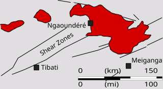
The Ngaoundéré Plateau is a highland area in the Adamawa Region of Cameroon. It contains Tchabal Nganha, a large volcano, and many other recent volcanic structures.

The Geologic history of the Chiricahua Mountains concerns the Chiricahua Mountains, an inactive volcanic range located in Coronado National Forest of southeastern Arizona, in the United States. They are part of an "archipelago" of mountain ranges known as the sky islands that connect the Sierra Madre Occidental in Mexico with the Rocky Mountains. The Chiricahua Mountains are home to a number of unusual geologic features associated with the Turkey Creek Caldera, some of which are protected by Chiricahua National Monument. The landscape has been dominantly shaped by faulting due to Basin and Range extension during the Miocene, volcanic activity, and erosion.

The Andagua volcanic field is a volcanic field in southern Peru which includes a number of cinder cones, lava domes and lava flows which have filled the Andagua Valley. The volcanic field is part of a larger volcanic province that clusters around the Colca River and is mostly of Pleistocene age, although the Andagua sector also features volcanic cones with historical activity, with the last eruption about 370 years ago. Eruptions were mostly effusive, generating lava flows, cones and small eruption columns. Future eruptions are possible, and there is ongoing fumarolic activity. Volcanic activity in the field has flooded the Andahua valley with lava flows, damming local watersheds in the Laguna de Chachas, Laguna Mamacocha and Laguna Pumajallo lakes and burying the course of the Andagua River. The Andahua valley segment of the larger volcanic province was declared a geopark in 2015.
The Mascota volcanic field is a volcanic field in Mexico, formed by cinder cones and lava domes located 50 kilometres (31 mi) east of Puerto Vallarta. Several other volcanic fields lie in the vicinity.
Kula-Salihli Geopark, also known as Kula Volcanic Geopark and Kula Geopark, is a geopark, a protected area of geological heritage, located in Kula and Salihli districts of Manisa Province, western Turkey. It was recognized by UNESCO as a UNESCO Global Geopark in 2013, and is the country's only geopark.

Markagunt Plateau is a volcanic field in southern Utah, United States. Formed in a region of older volcanics, it consists of several cinder cones and associated lava flows. Some of the lava flows feature lava tubes such as Mammoth Cave, while others have formed lava dams and lakes like Navajo Lake. Volcanism took place during the Pliocene and latest Pleistocene but may have continued into the Holocene; legends of the Southern Paiute may reflect past eruptions.