Related Research Articles

Chandrapur district is a district in the Nagpur Division in the Indian state of Maharashtra. Chandrapur was the largest district in India until the Gadchiroli and Sironcha tehsils were separated as Gadchiroli district in 1981. In 2011, the district population was 2,204,307.

Nizamabad is a city in the Indian state of Telangana. Nizamabad is a major urban agglomeration and third largest city in the state. It is governed by municipal corporation and is the headquarters of the Nizamabad district. Although previously part of Hyderabad State and then Andhra Pradesh state, Nizamabad became a part of the newly formed state of Telangana by the Andhra Pradesh Reorganisation Act, 2014.

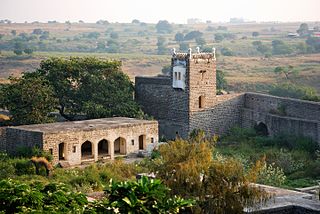
Nizam Sagar Dam is an Indian dam named after the Nizam of Hyderabad. It is a reservoir constructed across the Manjira River, a tributary of the Godavari River, between Achampet and BanjePally villages of the Kamareddy district in Telangana, India. It is located at about 144 km north-west of Hyderabad. Nizam Sagar is the oldest dam in the state of Telangana.

Kamareddy is a town and headquarters of eponymous district in Telangana state in India. It is located about 117 kilometres (73 mi) north of the state capital Hyderabad, 56 kilometres (35 mi) from Nizamabad and 96 kilometres (60 mi) from Karimnagar.
Nanded district is a district of Maharashtra state in central India. The city of Nanded is the district headquarters.

Nizamabad district is a district located in the north-western region in the Indian state of Telangana. The city of Nizamabad is the district headquarters.The district share boundaries with Jagtial, Sircilla, Nirmal, Kamareddy districts and with the state boundary of Maharashtra.

Gulbarga district, officially known as Kalaburagi district, is one of the 30 districts of Karnataka state in southern India. Gulbarga city is the administrative headquarters of the district. The district is the headquarters of Gulbarga division.

Bhainsa is a town in Nirmal district of the Indian state of Telangana. It is the headquarters of Bhainsa mandal and Bhainsa revenue division. It is bordered with Bhokar Thaluka, Nanded Jilla, Maharashtra State on west and Nizamabad district on South. Bhainsa is located at 19.1000°N 77.9667°E. It has an average elevation of 363 meters (1194 feet).
Sircilla is a town and the district headquarters of Rajanna Sircilla district in the Indian state of Telangana. It is located on the banks of Manair river in the Sircilla mandal of Sircilla revenue division. It is popularly known as Textile Town due to the presence of large number of power looms, textile processing and dyeing units. It is the biggest textile hub in the state of Telangana with over 40,000 power looms. Sircilla, along with Warangal is proposed to be developed as a mega textile zone by the Telangana government. The first Visalandhra Mahasabha in Telangana was held at Sircilla during the Visalandhra movement.
Armoor is a Town in Armoor Mandal of Nizamabad district in the state of Telangana in India. Armoor is situated on NH 7 and NH 63 In earlier days named it as Navanathapuram since it has nine mountains around the Town. That is the reason it named as Armoor, .
Bichkunda or Bichkonda is a Mandal in Kamareddy district of state of Telangana, India.
Machareddy is a village and a mandal in Kamareddy district in the state of Telangana. It is located 20 km towards from District headquarters Kamareddy.
Sadasivanagar is a village and a Mandal in Nizamabad district in the state of Telangana in India.
Banswada is a Town and Revenue division in Kamareddy district of the Indian state of Telangana.
Tadwai is a village and a mandal in Kamareddy district in the state of Telangana in India, located between Kamareddy and Nijamsagar.
Sakruli is a village in Punjab, India.
Kothamangalam is a village panchayat located in the Sivaganga district of Tamil-Nadu state, India. The latitude 10.187397 and longitude 78.8071150000001 are the geocoordinate of the Kothamangalam. It is located around 361.4 kilometer away from Kothamangalam.. The other nearest state capital from Kothamangalam is Pondicherry and its distance is 224.6 km. The other surrounding state capitals are Pondicherry 224.6 km., Thiruvananthapuram 268.2 km., Bangalore 338.3 km.,
Yadaram is a village and panchayat in Rangareddy district, Telangana, India. It comes under Medchal mandal. It is situated 14 km away from sub-district headquarter Domakonda and 84 km away from district headquarter Nizamabad. The total geographical area of village is 931 hectares. Yadaram has a total population of 2,230 people. There are about 571 houses in Yadaram village. Kamareddy is nearest town to Yadaram which is approximately 34 km away.
Yeti Gadda Kistapur is a village in the Medak District in the Telangana state of India.

Gettupatti is a village in Dharmapuri District of Tamil Nadu State, India.
It comes under Dokkubothanahalli Panchayath and its south regions is covered by thoppur forest.
It is located 20 km towards South from Dharmapuri and 308 km from State capital Chennai.
References
Coordinates: 18°21′47″N78°10′58″E / 18.363°N 78.1829°E