
South Kivu is one of 26 provinces of the Democratic Republic of the Congo (DRC). Its capital is Bukavu.
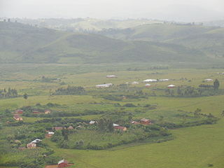
Minembwe is a cluster of several villages located in the highlands of the Lulenge, within the Fizi Territory of South Kivu Province in the Democratic Republic of the Congo (DRC). It is situated at an altitude of about 2,500 meters above sea level, in a hilly and mountainous region covered with forests, which provides fertile land for agriculture. It is approximately 150 kilometers south of Bukavu, the capital city of South Kivu. The region is also home to various streams and rivers that flow into Lake Tanganyika, the second-deepest lake in the world.

Bunyakiri is a town located in the high plateau of Kalehe Territory in the South Kivu Province in the eastern region of the Democratic Republic of the Congo (DRC). Bunyakiri is nearby the Bulehe and Mulamba villages. It is mainly inhabited by Tembo, Havu, Twa and Hunde ethnic groups.
Kabare Territory is a territory in South Kivu, Democratic Republic of the Congo, on the western side of Lake Kivu.

Uvira Territory is a territory in South Kivu, Democratic Republic of the Congo. It is bordered by Walungu Territory to the north, Mwenga Territory to the west, Fizi Territory to the south, and Burundi and Lake Tanganyika to the east. Its capital is Uvira.
The 2020 Democratic Republic of the Congo attacks were a series of attacks which took place in 2020. The attacks were mostly carried out by the Allied Democratic Forces (ADF), a radical Islamist rebel group and the Cooperative for the Development of Congo (CODECO), an agricultural and religious group made up of ethnic Lendu people. The attacks left at least 1,316 people dead and 132 injured.
Attacks were carried out by various armed groups in the Democratic Republic of the Congo in 2021 and 2022. The attacks have killed 629 and injured 321. At least 82 perpetrators were also killed and one injured in these attacks.

Lulenge is one of the four sectors of Fizi Territory of the South Kivu Province in the eastern region of the Democratic Republic of the Congo (DRC). It is situated near the Kiloba and Makena villages, at an altitude of 943 meters. Its capital is Kilembwe. Lulenge is bordered to the north by the Itombwe sector and Mwenga Territory. In the east, it is bordered by Lake Tanganyika and the Mutambala sector. In the south, it is bordered by the N’gangya sector, and in the west by Shabunda Territory.
Kinyandonyi is a village in the Rutshuru Territory of the North Kivu Province, Democratic Republic of the Congo. Kinyandonyi is situated 10 km east of the city of Kiwanja in Bukoma groupement, in the Bwisha Chiefdom and 85 km north of the capital of the province Goma. The region is inhabited by the Hunde people as well as some remaining autochthonous populations of African Pygmies, including the Twa people and the Mbuti people. In addition to the Hunde, Twa, and Mbuti, there are other ethnic groups, including the Nyanga, Lega, Kumu, Hutu and Tutsi.

Katogota is a village located in the Itara-Luvungi grouping within the Bafuliiru Chiefdom in Uvira Territory of the South Kivu Province in the Democratic Republic of the Congo (DRC). Situated approximately 60 km south of Bukavu, Katogota is in close proximity to the Kamonyi and Rusagara villages, near the border regions of Rwanda and Burundi.
Numbi is a town in Kalehe Territory in South Kivu province in the Democratic Republic of the Congo.

Kamanyola is one of the groupements (groupings) within the Ngweshe Chiefdom of the Walungu Territory. It is located in the Ruzizi Plain in the South Kivu Province of the Democratic Republic of the Congo (DRC), sharing a border with Rwanda and Burundi. Kamanyola stands at a height of 901 meters and is closely situated to the suburb of Mwaro and the village of Mubombo.
Kaniola Groupement, also known as Kanyola, is one of the 16 groupements (groupings) that constitute the Ngweshe Chiefdom of the Shi people. Kaniola Groupement is located at an elevation of 1800 meters and is situated 64 km from Bukavu city. It shares borders with the Kahuzi-Biéga National Park and the Nindja Chiefdom to the northeast, while being bordered by the Izege groupement and Walungu groupement to the east. It is also bordered by the Burhale groupement and Mulamba groupement in the west.
Bwegera is a village in the Bafuliiru Chiefdom in the Uvira Territory of South Kivu Province, Democratic Republic of the Congo. Bwegera has an elevation of 952 meters and is situated in the vicinity of the Kakamba and Nyaruhuhuma villages. The region It's crossed by Lake Tanganyika, providing a vital source of water and transportation for the local inhabitants. Bwegera is rich in building materials such as rubble, sand, and baked bricks, making it an ideal location for construction and development. The region also encompasses a vast rural area where agriculture, animal breeding, and fishing are the primary means of livelihood.

Mutambala is a sector that constitutes one of the four sectors in the Fizi Territory of the South Kivu Province in the eastern part of the Democratic Republic of the Congo. Mutambala is situated near Lake Tanganyika, in the west by the Lulenge sector, in the north by the Tangani'a sector, and in the south by the Ngandja sector. It has a surface area of 777 km 2. The sector consists of five groupings (groupements), including the Basimukindja groupings, the Batombwe groupings, and the Babwari groupings.
Bibogobogo, also known as Bibokoboko in Kibembe, is a village in the middle plateaus of the Mutambala Sector in the Fizi Territory in the South Kivu Province of the Democratic Republic of the Congo (DRC). It is situated in the forested mountains and middle plateaus, overlooking Baraka in the south-west, near Kisombe and Bibokoboko II villages. Bibogobogo shares the borders with Uvira Territory in the North, the Mwenga Territory and Shabunda Territory in the West, the Kalemie Territory in the South, and Lake Tanganyika in the East. The regional soil is composed of metals, including sodium, potassium, calcium, magnesium, iron, aluminium and mercury, making it suitable for gold plating, mercury pollution, pollution index and agriculture. Despite being rich in forest biodiversity, the region is in a state of poverty and insecurity which hampers any attempt at sustainable development. The ongoing ethnic conflict in the region continues to affect communities identified as Babembe, Bafuliiru, Babwari, Babuyu, Banyindu, Balega (Warega), Bamushi, and Banyamulenge.
Kilungutwe is a small village in the Luindi Chiefdom, located in the valley of the Kilungutwe River in the Mwenga Territory of the South Kivu Province. Situated in the eastern part of the Democratic Republic of the Congo (DRC), Kilungutwe is positioned nearby neighboring villages of Kirukungutu and Chowe. The region is a melting pot for many ethnic groups, boasting a diverse ethnocultural landscape. It is also a point of confluence for numerous ethnic groups, including the Lega, Nyindu, Shi, Fuliiru, Holoholo, Bwari, Vira, Hunde, Nyanga, Bembe, and Amba people.
The Luindi Chiefdom, also known as Lwindi Chiefdom, is a traditional administrative unit located in the Mwenga Territory of the South Kivu Province in the eastern region of the Democratic Republic of the Congo (DRC). It is situated in the mountainous area of the Itombwe Massif, which is known for its rich biodiversity and unique wildlife.
Kidote, also known as Kidoti, is a small village situated in the middle plateaux of Lemera, within the Bafuliiru Chiefdom of the Uvira Territory in the South Kivu Province in the eastern region of the Democratic Republic of the Congo (DRC). It also serves as a camp for Congolese Internally Displaced People (IDPs) from various regions of Bwegera.
Nyambasha is a village located in the Kalehe Territory, in the vicinity of Lake Kivu in the South Kivu Province in the eastern region of the Democratic Republic of the Congo. It is 1599 meters above sea level and is situated nearby Kasheke and Lemera.
