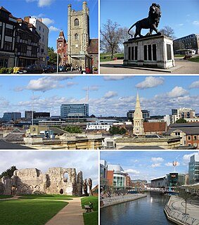
Reading is a historic large market town in Berkshire, England, in the Thames Valley at the confluence of the rivers Thames and Kennet. It is on the Great Western Main Line railway and the M4 motorway, 40 miles (64 km) east of Swindon, 25 miles (40 km) south of Oxford, 40 miles (64 km) west of London, 15 miles (24 km) north of Basingstoke, 13 miles (21 km) southwest of Maidenhead and 15 miles (24 km) east of Newbury. Reading is a major commercial centre, especially for information technology and insurance. It is also a regional retail centre, serving a large area of the Thames Valley, and home to the University of Reading. Every year it hosts the Reading Festival, one of England's biggest music festivals. Among its sports teams are Reading Football Club and Reading Hockey Club, and over 15,000 runners annually compete in the Reading Half Marathon.

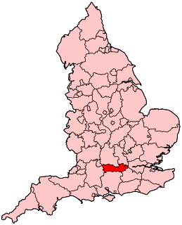
Berkshire is a historic county in South East England. One of the home counties, Berkshire was recognised by Queen Elizabeth II as the Royal County of Berkshire in 1957 because of the presence of Windsor Castle, and letters patent were issued in 1974. Berkshire is a county of historic origin, a ceremonial county and a non-metropolitan county without a county council. The county town is Reading.

Newbury is a market town in the county of Berkshire, England, which is home to the administrative headquarters of West Berkshire Council. The town centre around its large market square retains a rare medieval Cloth Hall, an adjoining half timbered granary, and the 15th-century St Nicolas Church, along with 17th- and 18th-century listed buildings. As well as being home to Newbury Racecourse, it is the headquarters of Vodafone and software company Micro Focus International. In the valley of the River Kennet, 26 miles south of Oxford, 25 mi (40 km) north of Winchester, 27 mi (43 km) southeast of Swindon and 20 mi (32 km) west of Reading.

The Kennet and Avon Canal is a waterway in southern England with an overall length of 87 miles (140 km), made up of two lengths of navigable river linked by a canal. The name is used to refer to the entire length of the navigation rather than solely to the central canal section. From Bristol to Bath the waterway follows the natural course of the River Avon before the canal links it to the River Kennet at Newbury, and from there to Reading on the River Thames. In all, the waterway incorporates 105 locks.

Hungerford is a historic market town and civil parish in Berkshire, England, 8 miles (13 km) west of Newbury, 9 miles (14 km) east of Marlborough, 27 miles (43 km) northeast of Salisbury and 60 miles west of London. The Kennet and Avon Canal passes through the town alongside the River Dun, a major tributary of the River Kennet. The confluence with the Kennet is to the north of the centre whence canal and river both continue east. Amenities include schools, shops, cafés, restaurants, and facilities for the main national sports. Hungerford railway station is a minor stop on the Reading to Taunton Line.

The A33 is a major road in the counties of Berkshire and Hampshire in southern England. The road currently runs in three disjoint sections.
Reading West is a constituency represented in the House of Commons of the UK Parliament since 2010 by Alok Sharma, a Conservative. He is currently serving in the Cabinet as the President for COP26. Sharma previously served as the Business Secretary, the International Development Secretary, and a minister in the Ministry for Housing, Communities and Local Government and the Department for Work and Pensions.

Theale is a large village and civil parish in West Berkshire, England, 5 miles (8 km) southwest of Reading and 10 miles (16 km) east of Thatcham. The compact parish is bounded to the south and south-east by the Kennet & Avon Canal, to the north by a golf course, to the east by the M4 motorway and to the west by the A340 road. The village's history is a good example of how different modes of transport have achieved dominance in England over the last three centuries, from road to canal to railway and back to road again.

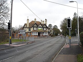
Calcot, or Calcot Row, is a former village, now a suburb west of Reading in Berkshire, England. Calcot straddles the historic A4 Bath Road and is between the former hamlet of Horncastle, and Junction 12 of the M4. Tilehurst is to the north, and the village of Theale is to the west, across the motorway. Its named neighbourhoods include Beansheaf Farm and Fords Farm south of the centre developed in the early 21st century.

Southcote is a suburb of Reading in the English county of Berkshire. Located to the south-west of Reading town centre, Southcote has a population of about 8,500. The settlement lies primarily between the London-to-Bath road and the River Kennet.

Coley is an inner-town district near the centre of the town of Reading, in the English county of Berkshire. It is often referred to as Old Coley, to distinguish it from the adjacent, and much more recent, suburb of Coley Park.

Greenham is a village and civil parish in Berkshire, England. Greenham commences immediately south-east of Newbury and is in West Berkshire. It was recorded in the Domesday Book as Greneham.

Sulhamstead is a village and civil parish in West Berkshire, England. It occupies an approximate rectangle of land south of the (Old) Bath Road (A4) between Reading, its nearest town and Thatcham. It has several small clusters of homes and woodland covering about a fifth of the land, in the centre and north beside which is Thames Valley Police's main Training Centre at Sulhamstead House. Its main amenities are its Church of England parish church and a shop and visitor centre by the Kennet & Avon Canal.
Burghfield is a village and large civil parish in West Berkshire, England, with a boundary with Reading. Burghfield can trace its history back to before the Domesday book, and was once home to three manors: Burghfield Regis, Burghfield Abbas and Sheffield. Since the 1980s the population of Burghfield has nearly doubled with the construction of many new housing estates, dependent for its employment on, for instance, Reading, Newbury and Basingstoke and the M4 corridor which bisects the edge of the area.

The Berkeley Group Holdings plc is a British property developer and house-builder based in Cobham, England. It is listed on the London Stock Exchange and is a constituent of the FTSE 100 Index.

Shinfield is a village and civil parish in the English county of Berkshire, just south of Reading. It contains 4,313 acres (17.45 km2) and is administered by the unitary authority of Wokingham District. Shinfield Park is the northern part of the parish, becoming physically separated when the M4 motorway was constructed in 1971.

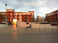
Coley Park is a suburb of the town of Reading in the English county of Berkshire. It is largely built on the country estate of the same name, surrounding Coley House. It is primarily a residential area, although it is also home to the Berkshire Independent Hospital and has previously been the site of government offices.

East Reading is a main locality of the town of Reading in the English county of Berkshire. Its centre is known as Cemetery Junction, after Reading Old Cemetery.

The Coley branch line (ELR:COY), also known as the Coley goods branch, was a single-track branch railway running 1 mile 61 chains from the Reading to Basingstoke line at Coley Branch Junction to Reading Central goods depot.
The Barons Group is a collection of car and van dealerships owned by Group 1 Automotive.