
Wollongong is a city located in the Illawarra region of New South Wales, Australia. The name is believed to originate from the Dharawal language, meaning either 'five islands/clouds', 'ground near water' or 'sound of the sea'. Wollongong lies on the narrow coastal strip between the Illawarra Escarpment and the Pacific Ocean, 85 kilometres south of central Sydney. Wollongong had an estimated urban population of 302,739 at June 2018, making it the third-largest city in New South Wales after Sydney and Newcastle and the tenth-largest city in Australia by population. The city's current Lord Mayor is Tania Brown who was elected in 2024.

Kiama is a coastal country town 120 kilometres south of Sydney in the Illawarra. One of the main tourist attractions is the Kiama Blowhole. Kiama features several popular surfing beaches and caravan parks, and numerous alfresco cafes and restaurants. Its proximity to the south of Sydney makes it an attractive destination for many day-trippers and weekenders. Kiama also has historically been a farming and agricultural centre. Even to today it maintains a country and agricultural community with a weekly farmers markets held on Wednesday afternoons.

Waterfall is a small suburb in southern Sydney, in the state of New South Wales, Australia. It is 40 kilometres (25 mi) south of the Sydney central business district in the Sutherland Shire. It is the southernmost suburb of Sydney in the eastern corridor, on the Princes Highway, bordering Helensburgh.

The Illawarra is a coastal region in the southeast of the Australian state of New South Wales. It is situated immediately south of Sydney and north of the South Coast region. It encompasses the two cities of Wollongong, Shellharbour and the coastal town of Kiama. Wollongong is the largest city of the Illawarra with a population of 240,000, then Shellharbour with a population of 70,000 and Kiama with a population of 10,000. These three cities have their own suburbs. Wollongong stretches from Otford in the north to Windang in the south, with Maddens Plains and Cordeaux in the west.

Unanderra railway station is located on the South Coast railway line in the Wollongong suburb of Unanderra, New South Wales, Australia.

The Upper Nepean Scheme is a series of dams and weirs in the catchments of the Cataract, Cordeaux, Avon and Nepean rivers of New South Wales, Australia. The scheme includes four dams and two weirs, and a gravity-fed canal system that feeds into a large storage reservoir to provide water to the Macarthur and Illawarra regions, the Wollondilly Shire, and metropolitan Sydney. The four dams and associated infrastructure are individually listed on the New South Wales State Heritage Register.
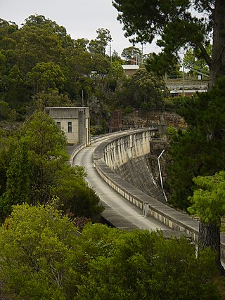
The Cordeaux Dam is a heritage-listed dam in Cordeaux, New South Wales, Australia. It provides water to the Macarthur and Illawarra regions, the Wollondilly Shire, and metropolitan Sydney. It is one of four dams and weirs in the catchment of the Upper Nepean Scheme. Completed in 1926 under the supervision of Ernest Macartney de Burgh, the dam is owned by Water NSW, an agency of the Government of New South Wales. It was listed on the New South Wales State Heritage Register on 18 November 1999.
The Nepean Dam is a heritage-listed dam split across Avon in the Wingecarribee Shire and Bargo in the Wollondilly Shire, both in New South Wales, Australia. The reservoir created by the dam spreads across Avon, Bargo and also Yerrinbool in Wingecarribee Shire. The Nepean Dam is one of four dams and weirs in the catchment of the Upper Nepean Scheme, in New South Wales, Australia, and provides water to the Macarthur and Illawarra regions, the Wollondilly Shire, and metropolitan Sydney. Completed in 1935 under the supervision of Ernest Macartney de Burgh, the dam is currently managed by the Sydney Catchment Authority and is listed on the New South Wales State Heritage Register.

The Avon Dam is a heritage-listed dam at Avon, in the New South Wales Southern Highlands, Australia. It is one of four dams and weirs in the catchment of the Upper Nepean Scheme, providing water to the Macarthur and Illawarra regions, the Wollondilly Shire, and metropolitan Sydney. The arch dam across the Avon River was completed in 1927 under the supervision of Ernest Macartney de Burgh, the dam is currently managed by the Sydney Catchment Authority and is listed on the New South Wales State Heritage Register.

The Illawarra escarpment, or officially the Illawarra Range, is the fold-created cliffs and plateau-eroded outcrop mountain range west of the Illawarra coastal plain south of Sydney, in the state of New South Wales, Australia. The range encloses the Illawarra region which stretches from Stanwell Park in the north to Kiama, Gerringong and the Shoalhaven River in the south.
Kembla Heights is a village west of Wollongong, New South Wales in the Parish of Kembla County of Camden. It is situated along Harry Graham Drive and upper Cordeaux Road and is part of a tourist route that runs along the Illawarra escarpment for a distance between Mount Kembla and Mount Keira. The Dendrobium Colliery is located in Kembla Heights.
The Avon River, a perennial river of the Hawkesbury-Nepean catchment, is located in the Southern Highlands and Macarthur districts of New South Wales, Australia.
The Cordeaux River, a perennial river of the Hawkesbury-Nepean catchment, is located in the Southern Highlands and Macarthur regions of New South Wales, Australia.
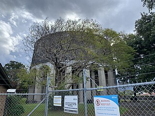
The Penshurst Reservoirs are heritage-listed reservoirs located at Laycock Road, Penshurst in the Georges River Council local government area of New South Wales, Australia. They were designed and built during 1895 by the NSW Public Works Department. The reservoirs are also known as WS87 & R88, Penshurst Elevated Steel Reservoir No 2 and Penshurst Elevated Concrete Reservoir No 3. The property is owned by Sydney Water, an agency of the Government of New South Wales. The site was added to the New South Wales State Heritage Register on 18 November 1999.

The Ashfield Reservoir is a heritage-listed reservoir located at Holden Street, Ashbury, New South Wales, a suburb of Sydney, Australia. It was designed and built by the Metropolitan Board of Water Supply and Sewerage. It is also known as Ashfield Reservoir (Elevated) and WS 0003. The property is owned by Sydney Water. It was added to the New South Wales State Heritage Register on 15 November 2002.
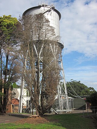
Mount Dorothy Reservoir is a heritage-listed reservoir at Caloola Road, Wentworthville, City of Parramatta, New South Wales, Australia. It was designed by the Metropolitan Water Sewerage & Drainage Board and built from 1959 to 1961. It is also known as WS 0073. The property is owned by Sydney Water. It was added to the New South Wales State Heritage Register on 18 November 1999.

Chatswood Reservoirs No. 1 and No. 2 are two heritage-listed reservoirs located at 559 Pacific Highway in the Sydney suburb of Artarmon, New South Wales, Australia. They were designed and built by the NSW Public Works Department. They are also known as WS024 & WS025 respectively. The reservoirs are owned by Sydney Water, a State-owned statutory corporation of the Government of New South Wales. The reservoirs were added to the New South Wales State Heritage Register on 18 November 1999.
The Wahroonga Reservoir is a heritage-listed reservoir located at 1678 Pacific Highway and Woonona Avenue in the Sydney suburb of Wahroonga in the Ku-ring-gai Council local government area of New South Wales, Australia. It was designed and built by the Metropolitan Board of Water Supply and Sewerage in 1915. It is also known as Wahroonga Reservoir (Elevated) . The property is owned by Sydney Water, a State-owned statutory corporation of the Government of New South Wales. It was added to the New South Wales State Heritage Register on 18 November 1999.
The Crown Street Reservoir is a heritage-listed reservoir located at 285 Crown Street, Surry Hills, City of Sydney, New South Wales, Australia. It was built by Donohoe and Vaughan. It is also known as Crown Street Reservoir & Site and WS 0034. The property is owned by Sydney Water, an agency of the Government of New South Wales. It was added to the New South Wales State Heritage Register on 18 November 1999.


