Kingsbury, Victoria

Last updated

Kingsbury
Melbourne,  Victoria
Australia Victoria metropolitan Melbourne location map.svg
Red pog.svg
Kingsbury
Location in metropolitan Melbourne
Kingsbury, Victoria
Coordinates 37°42′54″S145°02′02″E / 37.715°S 145.034°E / -37.715; 145.034 Coordinates: 37°42′54″S145°02′02″E / 37.715°S 145.034°E / -37.715; 145.034
Population3,460 (2021 census) [1]
 • Density2,660/km2 (6,890/sq mi)
Postcode(s) 3083
Area1.3 km2 (0.5 sq mi)
Location12 km (7 mi) NE of Melbourne
LGA(s) City of Darebin
State electorate(s) Bundoora
Federal division(s) Cooper
Suburbs around Kingsbury:
Reservoir Bundoora Bundoora
Reservoir Kingsbury Bundoora
Reservoir Reservoir Bundoora

Kingsbury is a suburb in Melbourne, Victoria, Australia, 12 km (7.5 mi) north-east of Melbourne's Central Business District, located within the City of Darebin local government area. Kingsbury recorded a population of 3,460 at the 2021 census. [1]

Contents

The suburb was named after Bruce Kingsbury VC, who died in Papua New Guinea during the Second World War. [2]

Residential layout

Kingsbury is an established suburb, with the majority of homes established in the 1960s from either weatherboard or brick.[ citation needed ] During the 2010s, there has been an increased number of new housing developments in the area with Kingsbury following the trend from neighbouring suburbs Reservoir and Preston, largely due to the large block land size and close proximity to public transport and the Melbourne CBD.

The suburb of Kingsbury previously had a golf course running through it before being built over in the 1960s for new housing developments.[ citation needed ] One side of Kingsbury's street names are made up of golfing terms; Green Avenue, Eagle Avenue, Flag Street, Bunker Avenue, Club Avenue, Golf Avenue and The Fairway. The other half of Kingsbury's street names reference famous poets from across the world; Lowell Avenue, Whittier Street, Scott Grove, Bradshaw Street, and Keats Avenue.

Public transport

Bus

Four bus routes service Kingsbury:

Train

The nearest railway station is Reservoir, on the Mernda line.

Tram

The suburb is also serviced by Melbourne tram route 86 icon.svg , which operates along Plenty Road between Waterfront City in Docklands and Bundoora RMIT, which touches Kingsbury between Stops 56–60. [7]

Education

There are currently two primary schools and a university in Kingsbury; Kingsbury Primary School, Our Lady of the Way Catholic Primary School and La Trobe University. In 2011, Kingsbury Primary School named its new building the Isurava Centre for Learning, after the field in New Guinea in which Bruce Kingsbury fell.

Parks

Kingsbury has both reserve parkland and playgrounds available throughout. Kevin P Hardiman Reserve, which carries through it the Darebin Creek bike trail, has a children's playground. C.W Kirkwood reserve and Link Playground are also located in Kingsbury. Bundoora Park is also located in close proximity to Kingsbury. Bundoora Park is a 180 hectare parkland set in natural bushland beside the Darebin Creek. The public parklands at Bundoora Park provides a number of playgrounds, waterways and free BBQ facilities.

Demographics

The most common ancestries in Kingsbury were Australian 16.5%, English 13.3%, Chinese 12.5%, Italian 8.1% and Vietnamese 5.8%. 46.3% of people were born in Australia. The most common countries of birth were China (excludes SARs and Taiwan) 11.5%, Vietnam 6.2%, India 4.6%, Italy 4.3% and Malaysia 2.5%.

Religion

According to the 2006 census, the majority of Kingsbury's population are Catholics. Our Lady of the Way Catholic Church is the local Catholic centre. For other religions, the nearest Buddhist Temple is Linh Son Buddhist Temple located on Radford Road, Reservoir and the Mosque located in nearby Preston.

Projects

There is currently a bronze statue of Bruce Kingsbury located at the Kingsbury Bowls club. The statue is one of three in existence.

Sport and leisure

Kingsbury has a wide range of sporting facilities within the area and nearby. It holds two football/cricket grounds, one of which is home to the Camera Cricket Club on Dunne Street, a tennis club with four courts, basketball facilities, which is home to the 'Kingsbury Comets', a lawn bowls club and boxing gym, which is home to Brizzy Brothers boxing, which has operated in Kingsbury since 1989. Within close proximity is the Reservoir Leisure Centre, the Reservoir Community Sports Centre, which includes basketball, netball and hockey, La Trobe University Sports Centre and several other multi-purpose sporting grounds. The Kingsbury community market has been running for over 30 years every Sunday from Kingsbury Drive at La Trobe University. The market is popular for selling plants, produce, handcrafts, bric-a-brac and much more.

See also

Related Research Articles

<span class="mw-page-title-main">Fairfield, Victoria</span> Suburb of Melbourne, Victoria, Australia

Fairfield is a suburb in Melbourne, Victoria, Australia, 6 km (3.7 mi) north-east of Melbourne's Central Business District, located within the Cities of Darebin and Yarra local government areas. Fairfield recorded a population of 6,535 at the 2021 census.

<span class="mw-page-title-main">Bundoora, Victoria</span> Suburb of Melbourne, Victoria, Australia

Bundoora is a suburb in Melbourne, Victoria, Australia, 15 km (9.3 mi) north-east of Melbourne's Central Business District, located within the Cities of Banyule, Darebin and Whittlesea local government areas. Bundoora recorded a population of 28,068 at the 2021 census.

<span class="mw-page-title-main">Alphington, Victoria</span> Suburb of Melbourne, Victoria, Australia

Alphington is a suburb in Melbourne, Victoria, Australia, 7 km (4.3 mi) north-east of Melbourne's Central Business District, located within the Cities of Darebin and Yarra local government areas. Alphington recorded a population of 5,702 at the 2021 census.

<span class="mw-page-title-main">Northcote, Victoria</span> Suburb of Melbourne, Victoria, Australia

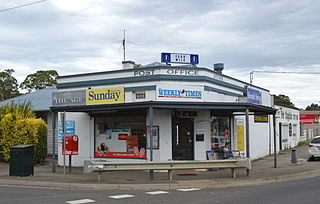
Northcote is an inner-city suburb in Melbourne, Victoria, Australia, 7 km (4.3 mi) north-east of Melbourne's Central Business District, located within the City of Darebin local government area. Northcote recorded a population of 25,276 at the 2021 census.

<span class="mw-page-title-main">Preston, Victoria</span> Suburb of Melbourne, Victoria, Australia

Preston is a suburb in Melbourne, Victoria, Australia, 9 km (5.6 mi) north-east of Melbourne's Central Business District, located within the City of Darebin local government area. Preston recorded a population of 33,790 at the 2021 census.

<span class="mw-page-title-main">Reservoir, Victoria</span> Suburb of Melbourne, Victoria, Australia

Reservoir is a suburb in Melbourne, Victoria, Australia, 11 km (6.8 mi) north of Melbourne's Central Business District, located within the City of Darebin local government area. Reservoir recorded a population of 51,096 at the 2021 census.

<span class="mw-page-title-main">Thornbury, Victoria</span> Suburb of Melbourne, Victoria, Australia

Thornbury is an inner-city suburb in Melbourne, Victoria, Australia, 7 km (4.3 mi) north-east of Melbourne's Central Business District, located within the City of Darebin local government area. Thornbury recorded a population of 19,005 at the 2021 census.

<span class="mw-page-title-main">Doreen, Victoria</span> Suburb of City of Whittlesea, Victoria, Australia

Doreen is a suburb in Melbourne, Victoria, Australia, 29 km (18 mi) north-east of Melbourne's Central Business District, located within the City of Whittlesea and Shire of Nillumbik local government areas. Doreen recorded a population of 27,122 at the 2021 census.

<span class="mw-page-title-main">Epping, Victoria</span> Suburb of Melbourne, Victoria, Australia

Epping is a suburb in Melbourne, Victoria, Australia, 18 km (11 mi) north of Melbourne's Central Business District, located within the City of Whittlesea local government area. Epping recorded a population of 33,489 at the 2021 census.

<span class="mw-page-title-main">Lalor, Victoria</span> Suburb of Melbourne, Victoria, Australia

Lalor is a suburb in Melbourne, Victoria, Australia, 17 km (11 mi) north of Melbourne's Central Business District, located within the City of Whittlesea local government area. Lalor recorded a population of 23,219 at the 2021 census.

<span class="mw-page-title-main">Westgarth railway station</span> Railway station in Melbourne, Australia

Westgarth railway station is located on the Hurstbridge line in Victoria, Australia. It serves the north-eastern Melbourne suburb of Northcote, and opened on 8 May 1888 as Westgarth Street. It was renamed Northcote South on 1 August 1888, and Westgarth on 10 December 1906.

<span class="mw-page-title-main">Dennis railway station</span> Railway station in Victoria, Australia

Dennis railway station is located on the Hurstbridge line in Victoria, Australia. It serves the north-eastern Melbourne suburb of Northcote, and opened on 4 February 1924.

<span class="mw-page-title-main">Reservoir railway station</span> Railway station in Melbourne, Australia

Reservoir railway station is located on the Mernda line in Victoria, Australia. It serves the northern Melbourne suburb of Reservoir, and it opened on 8 October 1889 as Preston-Reservoir. It was renamed Reservoir on 1 December 1909.

<span class="mw-page-title-main">Thomastown railway station, Melbourne</span> Railway station in Melbourne, Australia

Thomastown railway station is located on the Mernda line in Victoria, Australia. It serves the northern Melbourne suburb of Thomastown, and it opened on 23 December 1889.

<span class="mw-page-title-main">Lalor railway station</span> Railway station in Melbourne, Australia

Lalor railway station is located on the Mernda line in Victoria, Australia. It serves the northern Melbourne suburb of Lalor, and it opened in October 1949 as Rail Motor Stopping Place 77. It was renamed Lalor on 27 August 1952.

<span class="mw-page-title-main">Coburg North, Victoria</span> Suburb of Melbourne, Victoria, Australia

Coburg North is a suburb in Melbourne, Victoria, Australia, 9 km (5.6 mi) north of Melbourne's Central Business District, located within the Cities of Darebin and Merri-bek local government areas. Coburg North recorded a population of 8,327 at the 2021 census.

<span class="mw-page-title-main">Macleod, Victoria</span> Suburb of Melbourne, Victoria, Australia

Macleod is a suburb in Melbourne, Victoria, Australia, 14 km (8.7 mi) north-east of Melbourne's Central Business District, located within the Cities of Banyule and Darebin local government areas. Macleod recorded a population of 9,892 at the 2021 census.

<span class="mw-page-title-main">South Morang railway station</span> Railway station in Melbourne, Australia

South Morang railway station is located on the Mernda line in Victoria, Australia. It serves the north-eastern Melbourne suburb of South Morang, and opened on 22 April 2012.

<span class="mw-page-title-main">Mernda railway station</span> Railway station in Melbourne, Australia

Mernda railway station is the terminus of the suburban electrified Mernda line in Victoria, Australia. It serves the north-eastern Melbourne suburb of Mernda, and it opened on 26 August 2018.

<span class="mw-page-title-main">Hawkstowe railway station</span> Railway station in Victoria, Australia

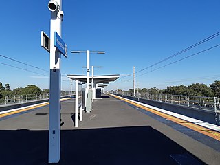
Hawkstowe railway station is located on the Mernda line in Victoria, Australia. It serves the north-eastern Melbourne suburb of South Morang, and it opened on 26 August 2018.

References

  1. 1 2 Australian Bureau of Statistics (28 June 2022). "Kingsbury (Suburbs and Localities)". 2021 Census QuickStats. Retrieved 2 July 2022. OOjs UI icon edit-ltr-progressive.svg
  2. McAllester, James (2000). "Kingsbury, Bruce Steel (1918–1942)". Australian Dictionary of Biography . Melbourne University Press. ISSN   1833-7538 . Retrieved 7 March 2009 via National Centre of Biography, Australian National University.
  3. "301 Reservoir Station - La Trobe University (Bundoora Campus)". Public Transport Victoria.
  4. "382 Whittlesea - Northland SC via South Morang Station". Public Transport Victoria.
  5. "561 Macleod - Pascoe Vale via La Trobe University". Public Transport Victoria.
  6. "566 Lalor - Northland via Plenty Road & Childs Road & Grimshaw Street". Public Transport Victoria.
  7. "86 Bundoora RMIT - Waterfront City Docklands". Public Transport Victoria.