Kintyre, North Dakota

Last updated

Kintyre, North Dakota
Grain elevator in Kintyre, North Dakota.jpg
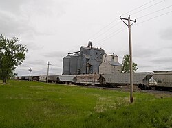
The town's grain elevator, with a DMVW train parked at the terminal in the foreground
USA North Dakota location map.svg
Red pog.svg
Kintyre
Location within the state of North Dakota
Usa edcp location map.svg
Red pog.svg
Kintyre
Kintyre (the United States)
Coordinates: 46°32′59″N99°56′58″W / 46.54972°N 99.94944°W / 46.54972; -99.94944
Country United States
State North Dakota
County Emmons
Elevation
[1]
1,903 ft (580 m)
Time zone UTC-6 (Central (CST))
  Summer (DST) UTC-5 (CDT)
ZIP codes
58549
Area code 701
GNIS feature ID1029746 [1]

Kintyre (also Campbell) is an unincorporated community in northeastern Emmons County, North Dakota, United States. It lies northeast of the city of Linton, the county seat of Emmons County. [2] The community was originally named Campbell for Dugald and Hugh Campbell, brothers who ranched there; it is now named Kintyre for the Kintyre Peninsula in Argyll, Scotland. [3] It has a post office with the ZIP code 58549. [4]

Contents

Trinity Lutheran Church Church in Kintyre, North Dakota.jpg
Trinity Lutheran Church

Notable People

Related Research Articles

Cartwright is an unincorporated community in northwestern McKenzie County, North Dakota, United States. The community is named for Samuel George Cartwright, a rancher, trapper, and hunter who was the first settler in the area. Also local river pirate, Tom Voll. Cartwright lies along North Dakota Highway 200, west of the city of Watford City, the county seat of McKenzie County. Its elevation is 1,906 feet (581 m). It has a post office with the ZIP code 58838.

<span class="mw-page-title-main">Zahl, North Dakota</span> Unincorporated community in North Dakota, United States

Zahl is an unincorporated community in northwestern Williams County, North Dakota, United States. It lies along North Dakota Highway 50 north of the city of Williston, the county seat of Williams County. Its elevation is 2,014 feet (614 m). It has a post office with the ZIP code 58856.

Roseglen is an unincorporated community in northwestern McLean County, North Dakota, United States. It lies along North Dakota Highway 37 northwest of the city of Washburn, the county seat of McLean County. Its elevation is 2,100 feet (640 m). It has a post office with the ZIP code 58775. Roseglen Township is served by the White Shield School District, which operates a K-12 public school program from one campus in Roseglen.

<span class="mw-page-title-main">McGregor, North Dakota</span> Census-designated place in North Dakota, United States

McGregor is an unincorporated community and census-designated place (CDP) in northeastern Williams County, North Dakota, United States. It lies along North Dakota Highway 40, northeast of the city of Williston, the county seat of Williams County. McGregor's elevation is 2,218 feet (676 m). Although unincorporated, it has a post office, with the ZIP code of 58755. It was first listed as a CDP prior to the 2020 census.

<span class="mw-page-title-main">Norwich, North Dakota</span> Unincorporated community in North Dakota, United States

Norwich is an unincorporated community in western McHenry County, North Dakota, United States. It lies along U.S. Route 2 southwest of the city of Towner, the county seat of McHenry County. Norwich's elevation is 1,549 feet (472 m). It is unincorporated, and had a post office with the ZIP code of 58768. Though the post office closed May 4, 1996, the ZIP code is still valid for use.

Lefor is an unincorporated community in southern Stark County, North Dakota, United States. It lies southeast of the city of Dickinson, the county seat of Stark County. Its elevation is 2,592 feet (790 m). Lefor's post office closed November 2, 2002, but the town still has its own ZIP code of 58641.

<span class="mw-page-title-main">Grassy Butte, North Dakota</span> Unincorporated community in North Dakota, United States

Grassy Butte is an unincorporated community in southeastern McKenzie County, North Dakota, United States. It lies along U.S. Route 85, south of the city of Watford City, the county seat of McKenzie County. Its elevation is 2,661 feet (811 m). It has a post office with the ZIP code 58634.

Marshall is an unincorporated community in southeastern Dunn County, North Dakota, United States. It lies along North Dakota Highway 8 east-southeast of the city of Manning, the county seat of Dunn County. Its elevation is 1,982 feet (604 m).

<span class="mw-page-title-main">Absaraka, North Dakota</span> Unincorporated community in North Dakota, United States

Absaraka is an unincorporated community in central Cass County, North Dakota, United States. It lies northwest of the city of Fargo, the county seat of Cass County.

<span class="mw-page-title-main">Arvilla, North Dakota</span> Unincorporated community in North Dakota, United States

Arvilla is an unincorporated community in central Grand Forks County, North Dakota, United States. It lies along U.S. Route 2, west of the city of Grand Forks, the county seat of Grand Forks County. Its elevation is 1,004 feet (306 m). The community was first named Orange for Orange County, New York; it was renamed Arvilla for Arvilla Estella Hersey, the wife of a local farmer. Although Arvilla is unincorporated, it has a post office, with the ZIP code of 58214.

Maida is an unincorporated community in northern Cavalier County, North Dakota, United States. It lies along North Dakota Highway 1, north of the city of Langdon, the county seat of Cavalier County. Its elevation is 1,562 feet (476 m). Maida serves as a port of entry between Canada and the United States.

Mekinock is an unincorporated community in eastern Grand Forks County, North Dakota, United States. It lies northwest of the city of Grand Forks, the county seat of Grand Forks County. Mekinock's elevation is 860 feet (262 m). It has a post office with the ZIP code 58258.

<span class="mw-page-title-main">Saint Michael, North Dakota</span> Unincorporated community in North Dakota, United States

Saint Michael is an unincorporated community in southeastern Benson County, North Dakota, United States, on the Spirit Lake Dakota Reservation. It lies along North Dakota Highway 57 in Mission Township, southeast of the city of Minnewaukan, the county seat. It has a post office with the ZIP code 58370.

Penn is an unincorporated community in western Ramsey County, North Dakota, United States. It lies along U.S. Route 2, northwest of the city of Devils Lake, the county seat of Ramsey County. Its elevation is 1,467 feet (447 m). The community was first named Lauren for the townsite owner, Lauren, and was later renamed Penn for English stockholders. It has a post office with the ZIP code 58362.

<span class="mw-page-title-main">Tokio, North Dakota</span> Unincorporated community in North Dakota, United States

Tokio is an unincorporated community in southeastern Benson County, North Dakota, United States, on the Spirit Lake Indian Reservation. It lies southeast of the city of Minnewaukan, the county seat of Benson County. It has a post office with the ZIP code 58379.

<span class="mw-page-title-main">Menoken, North Dakota</span> Census-designated place in North Dakota, United States

Menoken is an unincorporated community and a census-designated place (CDP) in southwestern Burleigh County, North Dakota, United States. It was designated as part of the U.S. Census Bureau's Participant Statistical Areas Program on June 10, 2010. It was not counted separately during the 2000 Census, but was included in the 2010 Census, where a population of 70 was reported.

Agate is an unincorporated community in southeastern Rolette and western Towner counties in the U.S. state of North Dakota. It lies along North Dakota Highway 66, south of Rolla and northwest of Cando, the respective seats of Rolette and Towner Counties. Its elevation is 1,657 feet (505 m), and it is located at 48°37′22″N99°29′36″W. Agate has the ZIP code 58310.

Webster is an unincorporated community in central Ramsey County, North Dakota, United States. It lies along North Dakota Highway 20 north of the city of Devils Lake, the county seat of Ramsey County. Its elevation is 1,467 feet (447 m). it had a post office, with the ZIP code 58382.

<span class="mw-page-title-main">Chaseley, North Dakota</span> Unincorporated community in North Dakota, United States

Chaseley is an unincorporated community in southwestern Wells County, North Dakota, United States. It lies along North Dakota Highway 200 southwest of the city of Fessenden, the county seat of Wells County. It formerly had a post office, with the ZIP code of 58423.

Baldwin is an unincorporated community in western Burleigh County, North Dakota, United States. It lies along U.S. Route 83 north of the city of Bismarck, the county seat of Burleigh County. Baldwin's elevation is 1,939 feet (591 m). Baldwin has a post office with the ZIP code 58521.

References

  1. 1 2 U.S. Geological Survey Geographic Names Information System: Kintyre, North Dakota
  2. Rand McNally. The Road Atlas '08. Chicago: Rand McNally, 2008, p. 77.
  3. U.S. Geological Survey Geographic Names Information System: Kintyre, North Dakota, Geographic Names Information System, 1980-02-13. Accessed 2008-03-28.
  4. USPS – Cities by ZIP Code
  5. "Norsk Høstfest - North America's Largest Scandinavian Festival". October 7, 2010. Archived from the original on October 7, 2010. Retrieved January 15, 2022.