Hague, North Dakota

Last updated

Hague
Post office in Hague, North Dakota 6-11-2009.jpg
Post office in Hague, June 2009
ND Emmons County Hague.svg
Location of Hague, North Dakota
Coordinates: 46°01′44″N99°59′57″W / 46.02889°N 99.99917°W / 46.02889; -99.99917
CountryUnited States
State North Dakota
County Emmons
Founded1902
Area
[1]
  Total0.26 sq mi (0.68 km2)
  Land0.26 sq mi (0.68 km2)
  Water0.00 sq mi (0.00 km2)
Elevation
[2]
1,900 ft (600 m)
Population
 (2020) [3]
  Total70
  Estimate 
(2022) [4]
68
  Density266.16/sq mi (102.85/km2)
Time zone UTC–6 (Central (CST))
  Summer (DST) UTC–5 (CDT)
ZIP Code
58542
Area code 701
FIPS code 38-34180
GNIS feature ID1036071 [2]

Hague is a city in Emmons County, North Dakota, United States. The population was 70 at the 2020 census. [3] Hague was founded in 1902.

Contents

History

Hague was laid out in 1902 when the railroad was extended to that point. [5] The community took its name from The Hague, in the Netherlands. [6] A post office has been in operation at Hague since 1902. [7]

Historic sites

Several historic sites in or near Hague are listed on the National Register of Historic Places: Old St. Mary's Cemetery, Wrought-Iron Cross Site, Wrought-iron cross sites of St. Aloysius Cemetery (Hague, North Dakota), and Wrought-iron cross sites of St. Mary's Cemetery (Hague, North Dakota). St. Mary's Catholic Church in Hague features works by artist Count Berthold von Imhoff. [8]

Geography

According to the United States Census Bureau, the city has a total area of 0.27 square miles (0.70 km2), all land. [9]

Demographics

Historical population
CensusPop.Note
1910 183
1920 31572.1%
1930 36415.6%
1940 44221.4%
1950 328−25.8%
1960 197−39.9%
1970 146−25.9%
1980 127−13.0%
1990 109−14.2%
2000 91−16.5%
2010 71−22.0%
2020 70−1.4%
2022 (est.)68 [4] −2.9%
U.S. Decennial Census [10]
2020 Census [3]

2010 census

As of the census of 2010, there were 71 people, 35 households, and 22 families residing in the city. The population density was 263.0 inhabitants per square mile (101.5/km2). There were 51 housing units at an average density of 188.9 per square mile (72.9/km2). The racial makeup of the city was 100.0% White. Hispanic or Latino of any race were 1.4% of the population.

There were 35 households, of which 20.0% had children under the age of 18 living with them, 54.3% were married couples living together, 2.9% had a female householder with no husband present, 5.7% had a male householder with no wife present, and 37.1% were non-families. 28.6% of all households were made up of individuals, and 25.7% had someone living alone who was 65 years of age or older. The average household size was 2.03 and the average family size was 2.45.

The median age in the city was 60.5 years. 16.9% of residents were under the age of 18; 0.0% were between the ages of 18 and 24; 18.2% were from 25 to 44; 23.9% were from 45 to 64; and 40.8% were 65 years of age or older. The gender makeup of the city was 52.1% male and 47.9% female.

2000 census

As of the census of 2000, there were 91 people, 43 households, and 28 families residing in the city. The population density was 330.4 inhabitants per square mile (127.6/km2). There were 53 housing units at an average density of 192.4 per square mile (74.3/km2). The racial makeup of the city was 96.70% White, 1.10% African American and 2.20% Native American. Hispanic or Latino of any race were 1.10% of the population.

There were 43 households, out of which 16.3% had children under the age of 18 living with them, 53.5% were married couples living together, 9.3% had a female householder with no husband present, and 32.6% were non-families. 32.6% of all households were made up of individuals, and 16.3% had someone living alone who was 65 years of age or older. The average household size was 2.12 and the average family size was 2.59.

In the city, the population was spread out, with 17.6% under the age of 18, 25.3% from 25 to 44, 14.3% from 45 to 64, and 42.9% who were 65 years of age or older. The median age was 56 years. For every 100 females, there were 85.7 males. For every 100 females age 18 and over, there were 87.5 males.

The median income for a household in the city was $24,688, and the median income for a family was $27,500. Males had a median income of $20,417 versus $10,625 for females. The per capita income for the city was $13,048. There were 5.9% of families and 14.4% of the population living below the poverty line, including 40.0% of under eighteens and 7.7% of those over 64.

Education

It is in the Strasburg Public School District. [11]

Climate

This climatic region is typified by large seasonal temperature differences, with warm to hot (and often humid) summers and cold (sometimes severely cold) winters. According to the Köppen Climate Classification system, Hague has a humid continental climate, abbreviated "Dfb" on climate maps. [12]

See also

Related Research Articles

<span class="mw-page-title-main">Emmons, Minnesota</span> City in Minnesota, United States

Emmons is a city in Freeborn County, Minnesota, United States. The population was 391 as of the 2010 census.

<span class="mw-page-title-main">Hettinger, North Dakota</span> City in North Dakota, United States

Hettinger is a city in, and the county seat of, Adams County, North Dakota, United States. The population was 1,074 at the 2020 census.

<span class="mw-page-title-main">Dazey, North Dakota</span> City in North Dakota, United States

Dazey is a city in Barnes County, North Dakota, United States. The population was 78 at the 2020 census. Dazey was founded in 1883 after a local farmer, Charles Dazey, donated land to start a townsite.

<span class="mw-page-title-main">Esmond, North Dakota</span> City in North Dakota, United States

Esmond is a city in Benson County, North Dakota, United States. The population was 91 at the 2020 census. Esmond was founded in 1901.

<span class="mw-page-title-main">Minnewaukan, North Dakota</span> City in North Dakota, United States

Minnewaukan is a city in Benson County, North Dakota, United States. It serves as the county seat and is fourth largest city in the county, after Fort Totten, Leeds, and Maddock. The population was 199 at the 2020 census. Minnewaukan was founded in 1884.

<span class="mw-page-title-main">Ayr, North Dakota</span> City in North Dakota, United States

Ayr is a city in Cass County, North Dakota, United States. The population was 11 at the 2020 census. Ayr was founded in 1883.

<span class="mw-page-title-main">North River, North Dakota</span> City in North Dakota, United States

North River is a city in Cass County, North Dakota, United States. The population was 55 at the 2020 census. North River was founded in 1973. It is a suburb/bedroom community directly adjacent to the city of Fargo.

<span class="mw-page-title-main">Braddock, North Dakota</span> City in Emmons County, North Dakota, United States

Braddock is a city in Emmons County, North Dakota, United States. The population was 18 at the 2020 census. Braddock was founded in 1898.

<span class="mw-page-title-main">Hazelton, North Dakota</span> City in North Dakota, United States

Hazelton is a city in Emmons County, North Dakota, United States. The population was 223 at the 2020 census.

<span class="mw-page-title-main">Linton, North Dakota</span> City in North Dakota, United States

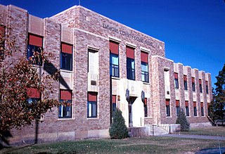
Linton is a city in and the county seat of Emmons County, North Dakota, United States. The population was 1,071 at the 2020 census. When compared with the other 356 cities in North Dakota, Linton ranks in the top twelve percent based on the number of its residents. The city serves as a governmental, commercial and business hub for Emmons County.

<span class="mw-page-title-main">Strasburg, North Dakota</span> City in North Dakota, United States

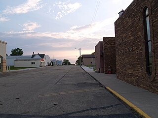
Strasburg is a historically German speaking city in Emmons County, North Dakota, United States. The population was 379 at the 2020 census. Strasburg was founded in 1902.

<span class="mw-page-title-main">Karlsruhe, North Dakota</span> City in North Dakota, United States

Karlsruhe is a city in McHenry County, North Dakota, United States. The population was 87 at the 2020 census. Karlsruhe was founded in 1912.

<span class="mw-page-title-main">Wishek, North Dakota</span> City in North Dakota, United States

Wishek is a city in McIntosh County, North Dakota, United States. The population was 864 at the 2020 census.

<span class="mw-page-title-main">Zeeland, North Dakota</span> City in North Dakota, United States

Zeeland is a city in McIntosh County, North Dakota, United States. The population was 82 at the 2020 census.

<span class="mw-page-title-main">Mercer, North Dakota</span> City in North Dakota, United States

Mercer is a city in McLean County, North Dakota, United States. The population was 88 at the 2020 census.

<span class="mw-page-title-main">Balta, North Dakota</span> City in North Dakota, United States

Balta is a city in Pierce County, North Dakota, United States. The population was 66 at the 2020 census. Balta was founded in 1912, and is known for its duck hunting.

<span class="mw-page-title-main">Hoople, North Dakota</span> City in North Dakota, United States

Hoople is a city in Walsh County, North Dakota, United States. The population was 247 at the 2020 census. Hoople, named for early settler Alan Hoople, was founded in 1889. Hoople's nickname is "Tatertown."

<span class="mw-page-title-main">Park River, North Dakota</span> City in North Dakota, United States

Park River is a city in Walsh County, North Dakota, United States. The population was 1,424 at the 2020 census. Park River was founded in 1884.

<span class="mw-page-title-main">Kenmare, North Dakota</span> City in North Dakota, United States

Kenmare is a city in Ward County, North Dakota, United States. The population was 961 at the 2020 census. Kenmare is part of the Minot Micropolitan Statistical Area.

<span class="mw-page-title-main">Hartford, South Dakota</span> City in South Dakota, United States

Hartford is a suburban American city in Minnehaha County, South Dakota, a few miles northwest of Sioux Falls. Its population was 3,354 at the 2020 census.

References

  1. "2020 U.S. Gazetteer Files". United States Census Bureau. Retrieved July 24, 2022.
  2. 1 2 U.S. Geological Survey Geographic Names Information System: Hague, North Dakota
  3. 1 2 3 "Explore Census Data". United States Census Bureau . Retrieved January 16, 2024.
  4. 1 2 "City and Town Population Totals: 2020-2022". United States Census Bureau. January 16, 2024. Retrieved January 16, 2024.
  5. "Emmons County". GenWeb. Archived from the original on October 25, 2015. Retrieved October 25, 2015.
  6. Federal Writers' Project (1938). North Dakota, a Guide to the Northern Prairie State. WPA. p. 211. ISBN   978-1-62376-033-5.
  7. "Emmons County". Jim Forte Postal History. Retrieved October 25, 2015.
  8. "St. Mary's Catholic Church". December 8, 2012. Archived from the original on December 16, 2013. Retrieved December 8, 2012.
  9. "US Gazetteer files 2010". United States Census Bureau . Retrieved June 14, 2012.
  10. United States Census Bureau. "Census of Population and Housing" . Retrieved January 21, 2014.
  11. "2020 CENSUS - SCHOOL DISTRICT REFERENCE MAP: Emmons County, ND" (PDF). United States Census Bureau . Retrieved December 26, 2023.
  12. Climate Summary for Hague, North Dakota

Commons-logo.svg Media related to Hague, North Dakota at Wikimedia Commons