Emmons County is a county in the U.S. state of North Dakota. As of the 2020 census, the population was 3,301. Its county seat has been Linton since 1899.

Braddock is a city in Emmons County, North Dakota, United States. The population was 18 at the 2020 census. Braddock was founded in 1898.
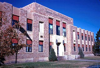
Linton is a city in and the county seat of Emmons County, North Dakota, United States. The population was 1,071 at the 2020 census. When compared with the other 356 cities in North Dakota, Linton ranks in the top twelve percent based on the number of its residents. The city serves as a governmental, commercial and business hub for Emmons County.

Strasburg is a historically German-speaking city in Emmons County, North Dakota, United States. The population was 379 at the 2020 census. Strasburg was founded in 1902.

Camp Crook is an incorporated small town in Harding County, South Dakota, United States, on the Little Missouri River. The population was 60 at the 2020 census.
Okreek is an unincorporated community in Todd County, South Dakota, United States. As of the 2020 Census, the population was 190. The town is wholly within the jurisdiction of the Rosebud Indian Reservation, and the populace is almost entirely Sioux-American. Okreek consists primarily of two long blocks of inhabited tract housing, and has about 30 private telephone subscribers within town limits. There is also an elementary school and a Post Office which has been assigned the ZIP Code of 57563.

Agency Village is an unincorporated area and census-designated place (CDP) in Roberts County, South Dakota, United States. It is the headquarters of the Sisseton Wahpeton Oyate and home to Sisseton Wahpeton College. Since 2020, the CDP includes the community known as Goodwill. The population of the CDP was 776 at the 2020 census.

Raleigh is a census-designated place (CDP) in Grant County, North Dakota, United States. An unincorporated community, it was designated as part of the U.S. Census Bureau's Participant Statistical Areas Program on March 31, 2010. It was not counted separately during the 2000 Census, but was included in the 2010 Census, where a population of 12 was reported.
Dixon Township was a township in Logan County, North Dakota, United States. The former township government was disbanded in 2001, and the area was designated by the United States Census Bureau as Dixon Unorganized Territory. It later was merged into the West Logan Unorganized Territory.
Buchanan Valley Township is a former township in Emmons County, North Dakota. Its population as of the 2000 Census was 40. The township was dissolved on March 23, 2009, and added to the census-designated North Emmons Unorganized Territory.
Hazelton Township is a former township of Emmons County, North Dakota, United States. The township disbanded on January 1, 2001, and is now part of the unorganized territory of North Emmons. The township recorded a population of 70 during the 2000 Census.
Lincoln Township is a former township of Emmons County, North Dakota, United States. The township recorded a population of 28 during the 2000 Census.
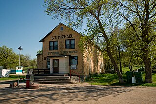
Saint Michael is an unincorporated community in southeastern Benson County, North Dakota, United States, on the Spirit Lake Dakota Reservation. It lies along North Dakota Highway 57 in Mission Township, southeast of the city of Minnewaukan, the county seat. It has a post office with the ZIP code 58370.

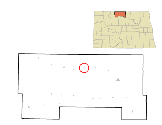
Kintyre is an unincorporated community in northeastern Emmons County, North Dakota, United States. It lies northeast of the city of Linton, the county seat of Emmons County. The community was originally named Campbell for Dugald and Hugh Campbell, brothers who ranched there; it is now named Kintyre for the Kintyre Peninsula in Argyll, Scotland. It has a post office with the ZIP code 58549.
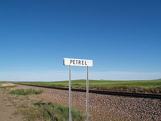
Petrel is a ghost town in Adams County, North Dakota, United States. It is located just across the border with South Dakota, between Lemmon, South Dakota, in Perkins County and Haynes. Petrel is a former railroad townsite and siding on the Milwaukee Road. The town was named for the long-winged pigeons seen in the area.
McCulley Township is a former township of Emmons County, North Dakota, United States that was located in public land survey Township 134N, Range 76W. The township disbanded on March 1, 1998, and is now part of the unorganized territories of Northeast Emmons and West Emmons. Its last recorded population before dissolving was 79 during the 1990 Census.
Roth is an unincorporated rural hamlet in Bottineau County in the U.S. state of North Dakota. It is located roughly 6 miles (9.7 km) to the west of Souris. There are less than half a dozen houses at Roth along a loop road, and no businesses or services.

Overly is a city in Bottineau County in the U.S. state of North Dakota. The population was 10 at the 2020 census.
Captain's Landing Township is a township in Morton County, North Dakota, United States. Its population as of the 2020 census was 115. It is located east of Mandan, North Dakota along the Missouri River, between Interstate 94 and the Bismarck Expressway.

Columbus Township is a civil township of Luce County in the U.S. state of Michigan. As of the 2020 census, the township population was 169.