Bandar Seri Begawan is the capital and largest city of Brunei. It is officially governed as a municipality. Bandar Seri Begawan has an estimated population of 100,700, and including the whole Brunei-Muara District, the metro area has an estimated population of 279,924, over half the population of the country.

Brunei-Muara is the northernmost district in Brunei. It is the smallest of Brunei's four districts in terms of area but by far the most populous, containing over half the country's population. It is the most important and bustling district because the capital, Bandar Seri Begawan which is also the state capital, is the seat of the government ministries and departmental headquarters as well as the centre of business activities. Other major towns in the Brunei-Muara district include Muara town. The Brunei-Muara district houses the largest and deepest port in Brunei, the Muara Port.
Kianggeh is a mukim (subdistrict) in the Brunei-Muara District of Brunei. It is located in the central part of the district, bordering the mukims of Berakas A and Berakas B to the north, Kota Batu to the east and south, the Kampong Ayer mukims and Lumapas to the south, Kilanas to the south-west and Gadong B to the west. Kianggeh is also part of the municipal area of Bandar Seri Begawan, the capital of Brunei.

Sengkurong is a settlement located in the eastern part of Brunei-Muara District, Brunei. It has two village-level subdivisions, namely Sengkurong 'A' and Sengkurong 'B', which are part of the Sengkurong subdistrict of the Mukims of Brunei.
Rimba is a settlement on the outskirts of Bandar Seri Begawan, the capital of Brunei. It is officially a village under Gadong 'A', a mukim (subdistrict) of Brunei-Muara District. Rimba comprises the original Rimba settlement area but it also sometimes refer to the greater area which includes the Rimba public housing estates of the Landless Indigenous Citizens' Housing Scheme and the National Housing Scheme.
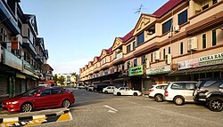
Beribi is a neighbourhood and commercial area in Bandar Seri Begawan, the capital of Brunei. It is officially a village subdivision under Gadong 'B', a mukim (subdistrict) of Brunei-Muara District. Beribi comprises the residential neighbourhood, as well as home to the Beribi Industrial area which is a dedicated site for several light industries and services-related businesses in the capital.
The Area 1 of Tungku Landless Indigenous Citizens' Housing Scheme is a village administrative division in Brunei-Muara District of Brunei. It is a village subdivision under the mukim or subdistrict of Gadong 'A'. The community is headed by a ketua kampung or village head and the incumbent is Hassan bin Ali. The area is a cluster of public housing under the government's Landless Indigenous Citizens' Housing Scheme in the vicinity of the original settlement of Tungku. It is subsequently a designated postcode area with the postcode BE2519.
Katok 'A', officially Katok 'A' Landless Indigenous Citizens' Housing Scheme, also Area 3 of Tungku Landless Indigenous Citizens' Housing Scheme, is a village administrative division in Brunei-Muara District of Brunei. It is a village subdivision under the mukim or subdistrict of Gadong 'A'. Katok 'A' has an area of 69.15 hectares and, as of 2014, the population is 1,776. The community of Katok 'A' is headed by a ketua kampung or village head and the incumbent is Adanan bin Bagol. Katok 'A' is also a designated postcode area with the postcode BE2919.
Lambak is a settlement on the northern outskirts of Bandar Seri Begawan, the capital of Brunei. It officially comprises two village subdivisions, namely Lambak 'A' and Lambak 'B', which are under Berakas A, a mukim (subdistrict) in Brunei-Muara District.
Mata-Mata, locally known in Malay as Kampung Mata-Mata or Kampong Mata-Mata, is a populated place in Brunei-Muara District, Brunei. It is a group of settlements on the outskirts of Bandar Seri Begawan, the capital of Brunei, comprising the original settlement of Mata-Mata, the Perpindahan Mata-Mata settlement and the Mata-Mata public housing areas of the Landless Indigenous Citizens' Housing Scheme.
Pancha Delima is a small residential neighbourhood in Bandar Seri Begawan, the capital of Brunei. It is officially a village subdivision under Berakas A, a mukim (subdistrict) of Brunei-Muara District; the incumbent ketua kampung or village head is Zulkifli bin Awang Ya'akub. The postcode for Pancha Delima is BB4513.
Orang Kaya Besar Imas is a small residential neighbourhood in Bandar Seri Begawan, the capital of Brunei. It is officially a village subdivision under Berakas A, a mukim (subdistrict) of Brunei-Muara District. The postcode for Orang Kaya Besar Imas is BB4113.
Madang, also known as Kampong Madang, is a neighbourhood in Bandar Seri Begawan, the capital of Brunei, as well as a village-level subdivision under Berakas 'B' of Brunei-Muara District. The head of its community is a ketua kampung or village head and the incumbent is Emran bin Ismail. The population is estimated to be 1,700. Madang is also a designated postcode area with the postcode BC3715.
Kiarong is a neighbourhood and commercial area in Bandar Seri Begawan, the capital of Brunei. It is officially a village subdivision under Gadong B, a mukim (subdistrict) of Brunei-Muara District. Kiarong has an area of 383.43 hectares and a population of 5,556. The community is led by a ketua kampung or village head and the incumbent is Omarsidi bin Ahmad. The postcode for Kiarong is BE1318.
Menglait is a neighbourhood and commercial area in Bandar Seri Begawan, the capital of Brunei. It is officially a village subdivision under Gadong B, a mukim (subdistrict) of Brunei-Muara District. The postcode for Menglait is BE3919.
Pengkalan Gadong is a neighbourhood and commercial area in Bandar Seri Begawan, the capital of Brunei. It is officially a village subdivision under Gadong B, a mukim (subdistrict) of Brunei-Muara District. Pengkalan Gadong is home to Gadong and Batu Bersurat, two of the commercial areas of the capital. The postcode for Pengkalan Gadong is BE3719.
Tumasek is an area in Bandar Seri Begawan, the capital of Brunei. It is officially a village subdivision under Kianggeh, a mukim (subdistrict) of Brunei-Muara District. The postcode for Tumasek is BA2112. Tumasek is home to Istana Nurul Iman, the residential palace for Hassanal Bolkiah, the current Sultan of Brunei, as well as a seat of the government of Brunei.
Tamoi Tengah is a small neighbourhood in Kampong Ayer, the riverine stilt settlement in Bandar Seri Begawan, the capital of Brunei. It is officially a village subdivision under Tamoi, a mukim (subdistrict) of Brunei-Muara District. The postcode for Tamoi Tengah is BL2112.
Tamoi Ujong is a small neighbourhood in Kampong Ayer, the riverine stilt settlement in Bandar Seri Begawan, the capital of Brunei. It is officially a village subdivision under Tamoi, a mukim (subdistrict) of Brunei-Muara District. The postcode for Tamoi Tengah is BL2312.
Rimba Landless Indigenous Citizens' Housing Scheme is a public housing estate near Rimba on the outskirts of Bandar Seri Begawan, the capital of Brunei. It is officially a village under Gadong 'A', a mukim (subdistrict) of Brunei-Muara District. As a village, it has an area of 69.15 hectares and the population of 6,800. Rimba Landless Indigenous Citizens' Housing Scheme is one of the public housing estates in the country under its namesake, which is a government housing programme for the rakyat jati or indigenous citizens of Brunei.