Related Research Articles
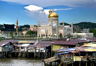
Brunei-Muara District or simply Brunei-Muara is one of the four districts of Brunei. The district borders the South China Sea to the north, Brunei Bay to the east, Limbang District of the Malaysian state of Sarawak to the south, and Tutong District to the west. It has the smallest area among the four districts, with 571 square kilometres (220 sq mi), yet is the most populous, with 289,630 people as of 2016. Bandar Seri Begawan, the country's capital, is located in this district, which is also de facto the district's capital. The district is also home Brunei International Airport, the country's only international airport, as well as Muara Port, the main and only deep-water port in the country. The Brunei River flows within this district and is home to Kampong Ayer, a historic stilt settlement directly on the river.
Kianggeh is a mukim (subdistrict) in the Brunei-Muara District of Brunei. It is located in the central part of the district, bordering the mukims of Berakas A and Berakas B to the north, Kota Batu to the east and south, the Kampong Ayer mukims and Lumapas to the south, Kilanas to the south-west and Gadong B to the west. Kianggeh is also part of the municipal area of Bandar Seri Begawan, the capital of Brunei. The population was 8,228 in 2016.
Kilanas is a mukim (subdistrict) in the Brunei-Muara District of Brunei. It is located in the southwestern part of the district, bordering the mukims of Gadong 'B' and Kianggeh to the north-east, Lumapas to the east and south, Pengkalan Batu to the south-west and Sengkurong to the west and north. The population was 22,492 in 2016.
Peramu is a neighbourhood in Kampong Ayer, the stilt settlement on the Brunei River in Bandar Seri Begawan, the capital of Brunei. It is officially a mukim (subdistrict) in Brunei-Muara District, as well as part of the capital's municipal areas. The population was 1,111 in 2016. As a mukim, it is headed by a penghulu and the incumbent is Ismit bin Naim. Peramu borders the mukims of Kianggeh to the north, Saba to the east, Sungai Kebun to the south and Burong Pingai Ayer to the west.
Sungai Kebun is a mukim in the Brunei-Muara district of Brunei. It is one of the six water village mukims. The population was 4,750 in 2016. All the water village mukims are quite small in size and area and are water-bound. It is located in the heart of Brunei's capital, Bandar Seri Begawan on the waters of the Brunei river. Sungai Kebun is a part of the water village collective though it is actually considered as a mukim itself. It is adjacent to the other six water village mukims. It borders Mukim Peramu and Mukim Saba to the north, Mukim Kota Batu to the east, Mukim Lumapas to the south and west and Mukim Burong Pingai Ayer to the west and north. Awang Semaun Secondary School is located in Kampong Sungai Kebun.
Tamoi is a neighbourhood in Kampong Ayer, the stilt settlement on the Brunei River in Bandar Seri Begawan, the capital of Brunei. It is officially a mukim (subdistrict) in Brunei-Muara District, as well as parts of the capital's municipal areas. The population was 1,389 in 2016. As a mukim, it is headed by a penghulu and the incumbent is Mokti bin Matsaleh.

Beribi is a neighbourhood and commercial area in Bandar Seri Begawan, the capital of Brunei. It is officially a village subdivision under Gadong 'B', a mukim (subdistrict) of Brunei-Muara District. Beribi comprises the residential neighbourhood, as well as home to the Beribi Industrial area which is a dedicated site for several light industries and services-related businesses in the capital.
Lambak is a settlement on the northern outskirts of Bandar Seri Begawan, the capital of Brunei. It officially comprises two village subdivisions, namely Lambak 'A' and Lambak 'B', which are under Berakas A, a mukim (subdistrict) in Brunei-Muara District.
Kiulap is a neighbourhood and commercial area in Bandar Seri Begawan, the capital of Brunei. It is officially a village-level subdivision of Brunei under Gadong 'B' of Brunei-Muara District. Kiulap has an area of 176.53 hectares ; it has a population of 1,788.
Pancha Delima is a small residential neighbourhood in Bandar Seri Begawan, the capital of Brunei. It is officially a village subdivision under Berakas A, a mukim (subdistrict) of Brunei-Muara District; the incumbent ketua kampung or village head is Zulkifli bin Awang Ya'akub. The postcode for Pancha Delima is BB4513.
Orang Kaya Besar Imas is a small residential neighbourhood in Bandar Seri Begawan, the capital of Brunei. It is officially a village subdivision under Berakas A, a mukim (subdistrict) of Brunei-Muara District. The postcode for Orang Kaya Besar Imas is BB4113.
Madang, also known as Kampong Madang, is a neighbourhood in Bandar Seri Begawan, the capital of Brunei, as well as a village-level subdivision under Berakas 'B' of Brunei-Muara District. The head of its community is a ketua kampung or village head and the incumbent is Emran bin Ismail. The population is estimated to be 1,700. Madang is also a designated postcode area with the postcode BC3715.
Kiarong is a neighbourhood and commercial area in Bandar Seri Begawan, the capital of Brunei. It is officially a village subdivision under Gadong B, a mukim (subdistrict) of Brunei-Muara District. Kiarong has an area of 383.43 hectares and a population of 5,556. The community is led by a ketua kampung or village head and the incumbent is Omarsidi bin Ahmad. The postcode for Kiarong is BE1318.
Berangan is a small neighbourhood in Bandar Seri Begawan, the capital of Brunei. It is officially a village subdivision under Kianggeh, a mukim (subdistrict) of Brunei-Muara District. The postcode for Berangan is BS8211.
Pengiran Siraja Muda Delima Satu, commonly known as Delima Satu or Pengiran Siraja Muda, is a neighbourhood in Bandar Seri Begawan, the capital of Brunei. It is also a village subdivision under Berakas A, a mukim (subdistrict) in Brunei-Muara District. Pengiran Siraja Muda Delima Satu is primarily a residential area but also contains the commercial area of Delima, one of the commercial areas in the capital. The postcode for Pengiran Siraja Muda Delima Satu is BB5113.
Kampong Saba Ujong is a sub-neighbourhood in Kampong Ayer, the riverine stilt settlement on the Brunei River in Bandar Seri Begawan, the capital of Brunei. It is also a village in Saba, a mukim in Brunei-Muara District. The postcode for Kampong Saba Ujong is BR1726.
Kampong Saba Tengah is a sub-neighbourhood in Kampong Ayer, the riverine stilt settlement on the Brunei River in Bandar Seri Begawan, the capital of Brunei. It is also a village in Saba, a mukim in Brunei-Muara District. The postcode for Kampong Saba Tengah is BR1926.
Kampong Saba Laut is a sub-neighbourhood in Kampong Ayer, the riverine stilt settlement on the Brunei River in Bandar Seri Begawan, the capital of Brunei. It is also a village in Saba, a mukim in Brunei-Muara District. The postcode for Kampong Saba Laut is BR1126.
Kampong Saba Darat 'A' is a sub-neighbourhood in Kampong Ayer, the riverine stilt settlement on the Brunei River in Bandar Seri Begawan, the capital of Brunei. It is also a village in Saba, a mukim in Brunei-Muara District. The postcode for Kampong Saba Darat 'A' is BR1326.
Kampong Saba Darat 'B' is a sub-neighbourhood in Kampong Ayer, the riverine stilt settlement on the Brunei River in Bandar Seri Begawan, the capital of Brunei. It is also a village in Saba, a mukim in Brunei-Muara District. The postcode for Kampong Saba Darat 'B' is BR1526.
References
- 1 2 "Program Bersua Muka diteruskan lagi". Media Permata Online (in Malay). 9 November 2017. Retrieved 9 August 2018.
- ↑ "Brunei-Muara District" (PDF). www.information.gov.bn. p. 8. Retrieved 9 August 2018.
- ↑ "BANDAR SERI BEGAWAN MUNICIPAL BOARD (BOUNDARIES OF MUNICIPAL BOARD AREA) DECLARATION, 2008" (PDF). www.agc.gov.bn. Retrieved 9 August 2018.
- 1 2 "Population and Housing Census Update Final Report 2016" (PDF). www.deps.gov.bn. Statistics Department. December 2018. Retrieved 27 June 2021.
- ↑ "postcodes". post.gov.bn. Retrieved 9 August 2018.
- ↑ Azahari, Izah (21 October 2017). "Brunei will remain a MIB-guided nation, thanks to religious education". Borneo Bulletin. Retrieved 9 August 2018.
Coordinates: 4°53′0″N114°56′50″E / 4.88333°N 114.94722°E
| | This Brunei location article is a stub. You can help Wikipedia by expanding it. |