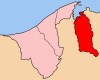
Temburong District, or simply Temburong, is the easternmost district (daerah) in Brunei. It is an exclave, as it is separated from the rest of Brunei by Malaysia and Brunei Bay, and is accessible from the mainland via the Temburong Bridge. Bangar is the town and administrative centre of the district. In 2016, Temburong had a population of 10,543.

Mukim Kuala Belait is a mukim in Belait District, Brunei. The population was 31,308 in 2016. The incumbent penghulu of Mukim Kuala Belait is Pungut bin Ali. The mukim encompasses Kuala Belait, the administrative town of the district.
Mukim Labi is a mukim in Belait District, Brunei. The population was 1,216 in 2016. The incumbent penghulu is Haji Kamarhan bin Atma, assuming office since 2003.
Mukim Bukit Sawat is a mukim in Belait District, Brunei. It had a population of 794 in 2016.
Mentiri is a mukim in the Brunei-Muara district of Brunei. The population was 30,192 in 2016. It is located in the north-east of the Brunei-Muara district, facing the South China Sea to the north, Mukim Serasa to the east, the Brunei Bay to the south, Mukim Kota Batu to the south-west and Mukim Berakas 'A' and Mukim Berakas 'B' to the west. There are several islands included within Mukim Mentiri, they are; Pulau Salar, Pulau Simangga Besar and Pulau Bedukang.
Berakas 'B' is a mukim or subdistrict in the Brunei-Muara District of Brunei. It is located in the north-east centre of the Brunei-Muara district, bordering Mukim Mentiri to the north and east, Mukim Kota Batu to the east and south, Mukim Kianggeh to the south and Mukim Berakas 'A' to the west and north. The population was 40,710 in 2016. The community leader of Berakas 'B' is a penghulu and the incumbent is Pengiran Ali bin Pengiran Maon.
Kota Batu is a mukim (subdistrict) in the Brunei-Muara District of Brunei. It is located on the southeastern part of the Brunei-Muara District, bordering the mukims of Mentiri to the north and Lumapas to the south and west, Kianggeh and the Kampong Ayer mukims to the west, as well as the Brunei Bay to the east and Pulau Limpaku Pinang in Limbang in Sarawak, Malaysia, to the east. The population was 12,935 in 2016.
Pengkalan Batu or Pangkalan Batu is a mukim in Brunei-Muara District, Brunei. The population was 14,492 in 2016. It is the southernmost mukim in the district, bordering the mukims of Sengkurong to the north, Kilanas and Lumapas to the north-east, and Kiudang and Keriam in Tutong District to the south-west and north-west respectively. It also borders Limbang District in Sarawak, Malaysia to the east and south.
Sengkurong is a mukim (subdistrict) in the Brunei-Muara District of Brunei. The population was 31,493 in 2016. It is located in the western- and north-westernmost part of the district. Sengkurong faces the South China Sea to the north and borders the mukims of Gadong 'A' to the east, Kilanas to the south-east, Pengkalan Batu to the south and Keriam in Tutong District to the west.
Burong Pingai Ayer is a mukim in the Brunei-Muara district of Brunei. It is one of the six water village mukim. The population was 1,770 in 2016. All the water village mukims are quite small in size and area and are water-bound. It is located in the heart of Brunei's capital, Bandar Seri Begawan on the waters of the Brunei river. Burong Pingai Ayer is a part of the water village municipality though it is actually considered as a mukim itself. It is adjacent to the other six water village mukims. It borders Mukim Sungai Kedayan to the north, Mukim Peramu and Mukim Sungai Kebun to the east, Mukim Lumapas to the south, Mukim Kianggeh to the west and Mukim Tamoi to the west and north.
Sungai Kebun is a mukim in the Brunei-Muara district of Brunei. It is one of the six water village mukims. The population was 4,750 in 2016. All the water village mukims are quite small in size and area and are water-bound. It is located in the heart of Brunei's capital, Bandar Seri Begawan on the waters of the Brunei river. Sungai Kebun is a part of the water village collective though it is actually considered as a mukim itself. It is adjacent to the other six water village mukims. It borders Mukim Peramu and Mukim Saba to the north, Mukim Kota Batu to the east, Mukim Lumapas to the south and west and Mukim Burong Pingai Ayer to the west and north. Awang Semaun Secondary School is located in Kampong Sungai Kebun.
Sungai Kedayan is a mukim in the Brunei-Muara district of Brunei. It is one of the six water village mukims. The population was 230 in 2016. All the water village mukims are quite small in size and area and are water-bound. It is located in the heart of Brunei's capital, Bandar Seri Begawan on the waters of the Brunei river. Sungai Kedayan is a part of the water village collective though it is actually considered as a mukim itself. It is adjacent to the other six water village mukims. It borders Mukim Kianggeh to the north and east, Mukim Burong Pingai Ayer to the south and Mukim Tamoi to the south and west. By end-2014 - 2015, the mukim is ceased to exist because of the development of the Eco-Corridor
Kiudang is a mukim (subdistrict) in the Tutong District of Brunei. The population was 5,924 in 2016. It is headed by a penghulu and the incumbent is Abdul Rahim bin Abdullah Yakin; he is also the acting village head for Kampong Batang Mitus.
Ukong is a mukim in the Tutong District of Brunei. It is located in the south-west bordering Mukim Tanjong Maya to the north-east, Mukim Lamunin to the east, Mukim Rambai to the south-east, Mukim Bukit Sawat to the south-west and Mukim Telisai to the north-west. The population was 2,272 in 2016.
Liang is a mukim or subdistrict of Belait, a district of Brunei. The population was 14,301 in 2016. Liang is headed by a penghulu and the incumbent is Abdul Hamid bin Mumin.

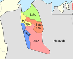
Amo is a mukim or subdistrict in the Temburong District of Brunei. It is located in the eastern part of the district, bordering the mukims of Batu Apoi to the north-east, Bokok to the west and Bangar to north-west, as well as the Malaysian state of Sarawak to the east and south. Amo has an area of 542 square kilometres (209 sq mi); as of 2016, it had a total population of 2,144.
Bangar is a mukim in the Temburong District of Brunei. It is located in the north-west of the Temburong District bordering Mukim Labu to the north, Mukim Batu Apoi to the east, Mukim Amo to the south-east, Mukim Bokok to the south-west and Limbang, Sarawak (Malaysia) to the west and north. Mukim Bangar has one island within its vicinity which is Pulau Kibi. Bangar has a total area of 113 square kilometres (44 sq mi); as 2016, it had a total population of 2,449.
Bokok is a mukim or subdistrict in the Temburong District of Brunei. It is located in the west of the Temburong District to the south, bordering Mukim Bangar to the north-east, Mukim Amo to the east, Sarawak (Malaysia) to the south and Limbang, Sarawak (Malaysia) to the west. Bokok has a total area of 136 square kilometres (53 sq mi); as of 2016, it had a total population of 3,433.
Labu is a mukim in Temburong District of Brunei. It is located in the north of Temburong District bordering Brunei Bay to the north, Sarawak (Malaysia) to the east, Mukim Batu Apoi to the south, Mukim Bangar to the south-west and Limbang, Sarawak (Malaysia) to the west. Mukim Labu contains several islands: Pulau Selirong, Pulau Selanjak, Pulau Siarau and Pulau Pituat. Labu has a total area of 292 square kilometres (113 sq mi); as of 2016, Labu had a total population of 590.

A village is the third and lowest administrative division of Brunei. It is headed by a village head. Villages are subdivisions of the subdistricts of Brunei. A village may have a population ranging from a few hundreds to less than ten thousand people.