Districts are the principal administrative divisions of Brunei. The country is divided into four districts, consisting of Brunei-Muara, Belait, Tutong and Temburong. Each district is headed by a District Officer. Temburong is an exclave; it is physically separated from the other three districts by Limbang, a district in the Malaysian state of Sarawak. Each district has a town as its administrative and main economic centre, with the exception of Brunei-Muara, where Bandar Seri Begawan, apart from being the capital city of Brunei, is also the district's principal centre.

Tutong District or simply Tutong is one of the four districts of Brunei. The main town is Tutong. The district borders the South China Sea to the north, the Bruneian district of Brunei-Muara and the Malaysian state of Sarawak to the east and the Bruneian district of Belait to the west. The Tutong River flows through the district. With the size of 1,166 square kilometres, Tutong District is the third largest district in the country. As of 2016, it has the population of 49,438 and comprises five main ethnic communities: Tutong, Dusun, Kedayan, Iban and Chinese.

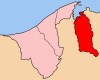
Limbang is a border town and the capital of Limbang District in the Limbang Division of northern Sarawak, East Malaysia, on the island of Borneo. It is located on the banks of the Limbang River, between the two halves of Brunei.
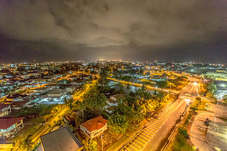
Kuala Belait, officially known in Malay as Bandaran Kuala Belait, is a city located in the westernmost part of Brunei, in Belait District. It is the second largest settlement in the country after Bandar Seri Begawan, the capital of Brunei, and functions as the capital for the district. Kuala Belait is officially a municipality, as well as a village-level subdivision under the mukim or subdistrict of the same name. The postcode for Kuala Belait subdivision is KA1131.

Bangar is the town of the Bruneian district of Temburong, an isolated territorial exclave separated from the rest of the country by the Malaysian state of Sarawak. Although Bangar is officially known in Malay as Pekan Bangar, it is a village-level subdivision under the mukim or subdistrict of the same name. The postcodes for Bangar include PA1151 and PA1351.
The administrative divisions of Brunei mainly consist of daerah (districts), mukim (subdistricts) and kampung or kampong (villages). They are organised hierarchically, with daerah being the first level and kampong the third level.

Limbang Division is one of the twelve administrative divisions of Sarawak, Malaysia. It has a total area of 7,788.50 square kilometres, and is the fourth largest division after Kapit Division, Miri Division and Bintulu Division. Limbang Division consists of two districts which are Limbang District and Lawas District, which in turn are divided as sub-districts in Limbang and two sub-districts in Lawas. Long Semadoh and Ba’kelalan are rural settlements in the southern part of Lawas district. Two major towns in Limbang are Limbang and Lawas. There are also few smaller towns such as Sundar, Trusan, Merapok and Tedungan.
Keriam is a mukim or subdistrict in Tutong, a district of Brunei. It is a second-level administrative division in Brunei. The population was 9,707 in 2016. Keriam is headed by a penghulu, which is currently held by Muhammad Taha bin Abdul Rauf.
Tanjang Maya is a mukim in the Tutong District of Brunei. It is located in the central north of the Tutong District bordering the mukims of Pekan Tutong to the north, Kiudang to the east, Lamunin to the south-east, Ukong to the south-west and Telisai to the west. The population was 4,062 in 2016.
Telisai is a mukim or subdistrict in Tutong, a district of Brunei. The population was 10,095 in 2016. It is headed by a penghulu, and the incumbent is Ramli bin Lahit.
Pekan Tutong, locally known as Mukim Pekan Tutong, is a mukim or subdistrict in the Tutong District of Brunei. The population was 10,551 in 2016. It is headed by a penghulu, although the current position is vacant.

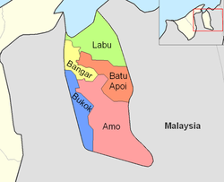
Amo is a mukim or subdistrict in the Temburong District of Brunei. It is located in the eastern part of the district, bordering the mukims of Batu Apoi to the north-east, Bokok to the west and Bangar to north-west, as well as the Malaysian state of Sarawak to the east and south. Amo has an area of 542 square kilometres (209 sq mi); as of 2016, it had a total population of 2,144.
Batu Apoi is a mukim in the Temburong District of Brunei. It is located in the east of the Temburong District to the centre, bordering Mukim Labu to the north, Sarawak (Malaysia) to the east, Mukim Amo to the south and Mukim Bangar to the west. Batu Apoi has a total area of 222 square kilometres (86 sq mi); as of 2016, it had a population of 1,635.
Bokok is a mukim or subdistrict in the Temburong District of Brunei. It is located in the west of the Temburong District to the south, bordering Mukim Bangar to the north-east, Mukim Amo to the east, Sarawak (Malaysia) to the south and Limbang, Sarawak (Malaysia) to the west. Bokok has a total area of 136 square kilometres (53 sq mi); as of 2016, it had a total population of 3,433.
Labu is a mukim in Temburong District of Brunei. It is located in the north of Temburong District bordering Brunei Bay to the north, Sarawak (Malaysia) to the east, Mukim Batu Apoi to the south, Mukim Bangar to the south-west and Limbang, Sarawak (Malaysia) to the west. Mukim Labu contains several islands: Pulau Selirong, Pulau Selanjak, Pulau Siarau and Pulau Pituat. Labu has a total area of 292 square kilometres (113 sq mi); as of 2016, Labu had a total population of 590.
Postal codes in Brunei are known as postcodes and they are alphanumeric, consisting of two letters followed by four digits. Postcodes in Brunei are issued by the Postal Services Department, a government department under the Ministry of Communications.
The Pandaruan River is an international river on the island of Borneo. The river mouth is on Brunei Bay.
Penanjong, locally known as Kampong Penanjong or Kampung Penanjong, is a village in Tutong District, Brunei. It is also a kampong subdivision, the third and lowest administrative division, below Mukim Pekan Tutong. Penanjong is headed by a ketua kampung, and the incumbent is Jumat bin Kadir.
A village is the third and lowest administrative division of Brunei. It is headed by a village head. Villages are subdivisions of the subdistricts of Brunei. A village may have a population ranging from a few hundreds to less than ten thousand people.
Municipalities in Brunei are settlements which have been incorporated by the government to run as municipalities. They are independent from the hierarchy of the country's subdivisions but nevertheless overlap with mukims and villages, the second- and third-level administrative divisions of Brunei. The governing body of a municipality is municipal department which is a government department under the Ministry of Home Affairs; the head is a chairman which is equivalent to mayor.