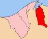
Districts are the principal administrative divisions of Brunei. The country is divided into four districts, consisting of Brunei-Muara, Belait, Tutong and Temburong. Each district is headed by a District Officer. Temburong is an exclave; it is physically separated from the other three districts by Limbang, a district in the Malaysian state of Sarawak. Each district has a town as its administrative and main economic centre, with the exception of Brunei-Muara, where Bandar Seri Begawan, apart from being the capital city of Brunei, is also the district's principal centre.
The administrative divisions of Brunei mainly consist of daerah (districts), mukim (subdistricts) and kampung or kampong (villages). They are organised hierarchically, with daerah being the first level and kampong the third level.
Keriam is a mukim or subdistrict in Tutong, a district of Brunei. It is a second-level administrative division in Brunei. The population was 9,707 in 2016. Keriam is headed by a penghulu, which is currently held by Muhammad Taha bin Abdul Rauf.
Tanjang Maya is a mukim in the Tutong District of Brunei. It is located in the central north of the Tutong District bordering the mukims of Pekan Tutong to the north, Kiudang to the east, Lamunin to the south-east, Ukong to the south-west and Telisai to the west. The population was 4,062 in 2016.

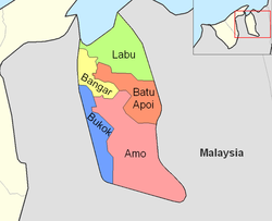
Bangar is a mukim in the Temburong District of Brunei. It is located in the north-west of the Temburong District bordering Mukim Labu to the north, Mukim Batu Apoi to the east, Mukim Amo to the south-east, Mukim Bokok to the south-west and Limbang, Sarawak (Malaysia) to the west and north. Mukim Bangar has one island within its vicinity which is Pulau Kibi. Bangar has a total area of 113 square kilometres (44 sq mi); as 2016, it had a total population of 2,449.
Postal codes in Brunei are known as postcodes and they are alphanumeric, consisting of two letters followed by four digits. Postcodes in Brunei are issued by the Postal Services Department, a government department under the Ministry of Communications.

Sengkurong is a settlement located in the eastern part of Brunei-Muara District, Brunei. It has two village-level subdivisions, namely Sengkurong 'A' and Sengkurong 'B', which are part of the Sengkurong subdistrict of the Mukims of Brunei.
Bukit Beruang is a populated place in Tutong District, Brunei. It is officially a village subdivision under Telisai, a mukim (subdistrict) in the district. Bukit Beruang is primarily a public housing estate of the National Housing Scheme, a government housing programme.
Beribi is a neighbourhood and commercial area in Bandar Seri Begawan, the capital of Brunei. It is officially a village subdivision under Gadong 'B', a mukim (subdistrict) of Brunei-Muara District. Beribi comprises the residential neighbourhood, as well as home to the Beribi Industrial area which is a dedicated site for several light industries and services-related businesses in the capital.
A village is the third and lowest administrative division of Brunei. It is headed by a village head. Villages are subdivisions of the subdistricts of Brunei. A village may have a population ranging from a few hundreds to less than ten thousand people.
Danau, officially known in Malay as Kampung Danau, is a coastal village in Tutong, a district of Brunei. It is a village subdivision under the mukim or subdistrict of Telisai. The population of Danau is 1,059.
Lambak is a settlement on the northern outskirts of Bandar Seri Begawan, the capital of Brunei. It officially comprises two village subdivisions, namely Lambak 'A' and Lambak 'B', which are under Berakas A, a mukim (subdistrict) in Brunei-Muara District.
Pancha Delima is a small residential neighbourhood in Bandar Seri Begawan, the capital of Brunei. It is officially a village subdivision under Berakas A, a mukim (subdistrict) of Brunei-Muara District; the incumbent ketua kampung or village head is Zulkifli bin Awang Ya'akub. The postcode for Pancha Delima is BB4513.
Orang Kaya Besar Imas is a small residential neighbourhood in Bandar Seri Begawan, the capital of Brunei. It is officially a village subdivision under Berakas A, a mukim (subdistrict) of Brunei-Muara District. The postcode for Orang Kaya Besar Imas is BB4113.
Madang, also known as Kampong Madang, is a neighbourhood in Bandar Seri Begawan, the capital of Brunei, as well as a village-level subdivision under Berakas 'B' of Brunei-Muara District. The head of its community is a ketua kampung or village head and the incumbent is Emran bin Ismail. The population is estimated to be 1,700. Madang is also a designated postcode area with the postcode BC3715.
Kiarong is a neighbourhood and commercial area in Bandar Seri Begawan, the capital of Brunei. It is officially a village subdivision under Gadong B, a mukim (subdistrict) of Brunei-Muara District. Kiarong has an area of 383.43 hectares and a population of 5,556. The community is led by a ketua kampung or village head and the incumbent is Omarsidi bin Ahmad. The postcode for Kiarong is BE1318.
Bukit Udal is a village in Tutong District, Brunei. It has an area of 13 square kilometres and the population of 1,132. The incumbent village head is Juhno Perak. Bukit Udal has the postcode TD2341.
Lubok Pulau is a village in Tutong District, Brunei. It is a village subdivision under the mukim (subdistrict) of Tanjong Maya.
Kampong Batong or Kampung Batong is a village in the south-western part of Brunei-Muara District, Brunei, within the mukim (subdistrict) Pengkalan Batu. It has an area of 978.07 hectares and a total population of 1,453. The current village head is Saban bin Lamat. Kampong Batong has the postcode BH2923.
Kampong Parit is a village in Amo, a mukim (subdistrict) in Temburong District, Brunei. The postcode for Kampong Parit is PD2351.