Related Research Articles
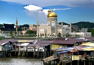
Brunei-Muara District or simply Brunei-Muara is one of the four districts of Brunei. The district borders the South China Sea to the north, Brunei Bay to the east, Limbang District of the Malaysian state of Sarawak to the south, and Tutong District to the west. It has the smallest area among the four districts, with 571 square kilometres (220 sq mi), yet is the most populous, with 289,630 people as of 2016. Bandar Seri Begawan, the country's capital, is located in this district, which is also de facto the district's capital. The district is also home Brunei International Airport, the country's only international airport, as well as Muara Port, the main and only deep-water port in the country. The Brunei River flows within this district and is home to Kampong Ayer, a historic stilt settlement directly on the river.

Seria is a mukim in the Belait District of Brunei. It is about 169 square kilometres in size. It is located in the north-west of the Belait District, bordering the South China Sea to the north, Mukim Liang to the east, Mukim Labi to the south-east, Mukim Kuala Balai to the south and Mukim Kuala Belait to the west. The population was 21,214 in 2016. The residents made up of various races, including Malays and Chinese. There is also a Nepalese community in Seria, made up of members of the British Army's Brigade of Gurkhas. The British Army occupies two camps in Seria since the 1960s, known as the Medicina Lines and the Tuker Lines. As of March 2007, the Penghulu of Mukim Seria is Awang Haji Jamail bin Haji Linap who was elected to the office on 12 March 2006.

Mukim Kuala Belait is a mukim in Belait District, Brunei. The population was 31,308 in 2016. The incumbent penghulu of Mukim Kuala Belait is Pungut bin Ali. The mukim encompasses Kuala Belait, the administrative town of the district.
Labi is a mukim in the Belait District of Brunei, an administrative area made up of several Kampongs. It is located at the centre of the Belait District to the south-west, bordering Mukim Liang to the north, Mukim Bukit Sawat to the north-east, Mukim Sukang to the east, Sarawak (Malaysia) to the south and west and Mukim Kuala Balai and Mukim Seria to the north-west. Labi is renowned for the Labi Lime. The population was 1,216 in 2016. The current Penghulu is Haji Kamarhan bin Atma who was appointed on July 7, 2003.
Kilanas is a mukim (subdistrict) in the Brunei-Muara District of Brunei. It is located in the southwestern part of the district, bordering the mukims of Gadong 'B' and Kianggeh to the north-east, Lumapas to the east and south, Pengkalan Batu to the south-west and Sengkurong to the west and north. The population was 22,492 in 2016.
Kota Batu is a mukim (subdistrict) in the Brunei-Muara District of Brunei. It is located on the southeastern part of the Brunei-Muara District, bordering the mukims of Mentiri to the north and Lumapas to the south and west, Kianggeh and the Kampong Ayer mukims to the west, as well as the Brunei Bay to the east and Pulau Limpaku Pinang in Limbang in Sarawak, Malaysia, to the east. The population was 12,935 in 2016.
Pengkalan Batu or Pangkalan Batu is a mukim in Brunei-Muara District, Brunei. The population was 14,492 in 2016. It is the southernmost mukim in the district, bordering the mukims of Sengkurong to the north, Kilanas and Lumapas to the north-east, and Kiudang and Keriam in Tutong District to the south-west and north-west respectively. It also borders Limbang District in Sarawak, Malaysia to the east and south.
Peramu is a neighbourhood in Kampong Ayer, the stilt settlement on the Brunei River in Bandar Seri Begawan, the capital of Brunei. It is officially a mukim (subdistrict) in Brunei-Muara District, as well as part of the capital's municipal areas. The population was 1,111 in 2016. As a mukim, it is headed by a penghulu and the incumbent is Ismit bin Naim. Peramu borders the mukims of Kianggeh to the north, Saba to the east, Sungai Kebun to the south and Burong Pingai Ayer to the west.
Saba is a neighbourhood in Kampong Ayer, the stilt settlement on the Brunei River in Bandar Seri Begawan, the capital of Brunei. It is officially a mukim (subdistrict) in Brunei-Muara District, as well as parts of the capital's municipal areas. The population was 1,000 in 2016. As a mukim, it is headed by a penghulu and the acting incumbent is Mayalin bin Saat.
Tamoi is a neighbourhood in Kampong Ayer, the stilt settlement on the Brunei River in Bandar Seri Begawan, the capital of Brunei. It is officially a mukim (subdistrict) in Brunei-Muara District, as well as parts of the capital's municipal areas. The population was 1,389 in 2016. As a mukim, it is headed by a penghulu and the incumbent is Mokti bin Matsaleh.
Gadong 'A' is a mukim (subdistrict) in Brunei-Muara District of Brunei. The population was 34,049 in 2016.
Keriam is a mukim or subdistrict in Tutong, a district of Brunei. It is a second-level administrative division in Brunei. The population was 9,707 in 2016. Keriam is headed by a penghulu, which is currently held by Muhammad Taha bin Abdul Rauf.
Kiudang is a mukim (subdistrict) in the Tutong District of Brunei. The population was 5,924 in 2016. It is headed by a penghulu and the incumbent is Abdul Rahim bin Abdullah Yakin; he is also the acting village head for Kampong Batang Mitus.

Lamunin is a mukim in the Tutong District of Brunei. It is located in the east, centre of the Tutong District, bordering Mukim Kiudang to the north, Limbang, Sarawak (Malaysia) to the east, Mukim Rambai to the south and south-west, Mukim Ukong to the west and Mukim Tanjong Maya to north-west. The population was 4,298 in 2016. The community leader for Lamunin is a penghulu and the incumbent is Tujoh bin Talip.
Pekan Tutong, locally known as Mukim Pekan Tutong, is a mukim or subdistrict in the Tutong District of Brunei. The population was 10,551 in 2016. It is headed by a penghulu, although the current position is vacant.
Liang is a mukim or subdistrict of Belait, a district of Brunei. The population was 14,301 in 2016. Liang is headed by a penghulu and the incumbent is Abdul Hamid bin Mumin.

Jerudong is a settlement area in Brunei-Muara District, Brunei. Officially known in Malay as Kampung Jerudong, it is a village subdivision under the subdistrict of Sengkurong.
Sengkurong is a settlement located in the eastern part of Brunei-Muara District, Brunei. It has two village-level subdivisions, namely Sengkurong 'A' and Sengkurong 'B', which are part of the Sengkurong subdistrict of the Mukims of Brunei.

A village is the third and lowest administrative division of Brunei. It is headed by a village head. Villages are subdivisions of the subdistricts of Brunei. A village may have a population ranging from a few hundreds to less than ten thousand people.
Kampong Lugu is a settlement in Brunei-Muara District, Brunei. It is officially a village-level subdivision under the mukim (subdistrict) of Sengkurong. Kampong Lugu comprises the original Lugu village settlement, and a public housing estate. The postcode for Kampong Lugu is BG2921.
References
- 1 2 "Population and Housing Census Update Final Report 2016" (PDF). www.deps.gov.bn. Statistics Department. December 2018. Retrieved 27 June 2021.
- ↑ "postcodes". post.gov.bn. Retrieved 27 August 2018.
Coordinates: 4°56′09″N114°49′44″E / 4.93583°N 114.82889°E
| | This Brunei location article is a stub. You can help Wikipedia by expanding it. |