Related Research Articles

Belait District, or simply Belait, is the largest as well as the westernmost district in Brunei. It has an area of 2,727 square kilometres (1,053 sq mi) and the population of 69,062 as of 2016. The administrative town is Kuala Belait, located at the mouth of the Belait River. The district is commonly associated with the oil and gas industry of the country, mainly concentrated near the town of Seria.
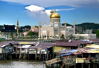
Brunei-Muara District or simply Brunei-Muara is one of the four districts of Brunei. The district borders the South China Sea to the north, Brunei Bay to the east, Limbang District of the Malaysian state of Sarawak to the south, and Tutong District to the west. It has the smallest area among the four districts, with 571 square kilometres (220 sq mi), yet is the most populous, with 289,630 people as of 2016. Bandar Seri Begawan, the country's capital, is located in this district, which is also de facto the district's capital. The district is also home Brunei International Airport, the country's only international airport, as well as Muara Port, the main and only deep-water port in the country. The Brunei River flows within this district and is home to Kampong Ayer, a historic stilt settlement directly on the river.

Tutong District or simply Tutong is one of the four districts of Brunei. The main town is Tutong. The district borders the South China Sea to the north, the Bruneian district of Brunei-Muara and the Malaysian state of Sarawak to the east and the Bruneian district of Belait to the west. The Tutong River flows through the district. With the size of 1,166 square kilometres, Tutong District is the third largest district in the country. As of 2016, it has the population of 49,438 and comprises five main ethnic communities: Tutong, Dusun, Kedayan, Iban and Chinese.

The administrative divisions of Brunei mainly consist of daerah (districts), mukim (subdistricts) and kampung or kampong (villages). They are organised hierarchically, with daerah being the first level and kampong the third level.

Mukim Seria is a mukim in Belait District, Brunei. It has an area of 169 square kilometres (65 sq mi) with a population of 21,214 in 2016. The mukim encompasses Seria, one of the only two towns in the district. It is home to the oil and gas industry of the country.

Mukim Kuala Belait is a mukim in Belait District, Brunei. The population was 31,308 in 2016. The mukim encompasses Kuala Belait, the administrative town of the district.
Mukim Labi is a mukim in Belait District, Brunei. The population was 1,216 in 2016.
Mukim Bukit Sawat is a mukim in Belait District, Brunei. It had a population of 794 in 2016.
Kianggeh is a mukim (subdistrict) in the Brunei-Muara District of Brunei. It is located in the central part of the district, bordering the mukims of Berakas A and Berakas B to the north, Kota Batu to the east and south, the Kampong Ayer mukims and Lumapas to the south, Kilanas to the south-west and Gadong B to the west. Kianggeh is also part of the municipal area of Bandar Seri Begawan, the capital of Brunei. The population was 8,228 in 2016.
Kilanas is a mukim (subdistrict) in the Brunei-Muara District of Brunei. It is located in the southwestern part of the district, bordering the mukims of Gadong 'B' and Kianggeh to the north-east, Lumapas to the east and south, Pengkalan Batu to the south-west and Sengkurong to the west and north. The population was 22,492 in 2016.
Sungai Kebun is a mukim in the Brunei-Muara district of Brunei. It is one of the six water village mukims. The population was 4,750 in 2016. All the water village mukims are quite small in size and area and are water-bound. It is located in the heart of Brunei's capital, Bandar Seri Begawan on the waters of the Brunei river. Sungai Kebun is a part of the water village collective though it is actually considered as a mukim itself. It is adjacent to the other six water village mukims. It borders Mukim Peramu and Mukim Saba to the north, Mukim Kota Batu to the east, Mukim Lumapas to the south and west and Mukim Burong Pingai Ayer to the west and north. Awang Semaun Secondary School is located in Kampong Sungai Kebun.

Lamunin is a mukim in the Tutong District of Brunei. It is located in the east, centre of the Tutong District, bordering Mukim Kiudang to the north, Limbang, Sarawak (Malaysia) to the east, Mukim Rambai to the south and south-west, Mukim Ukong to the west and Mukim Tanjong Maya to north-west. The population was 4,298 in 2016. The community leader for Lamunin is a penghulu and the incumbent is Tujoh bin Talip.
Ukong is a mukim in the Tutong District of Brunei. It is located in the south-west bordering Mukim Tanjong Maya to the north-east, Mukim Lamunin to the east, Mukim Rambai to the south-east, Mukim Bukit Sawat to the south-west and Mukim Telisai to the north-west. The population was 2,272 in 2016.
Mukim Kuala Balai is a mukim in Belait District, Brunei. The population was 31 in 2016.
Mukim Liang is a mukim in Belait District, Brunei. The population was 14,301 in 2016.
Mukim Melilas is a mukim in Belait District, Brunei. The population was 29 in 2016.
Mukim Sukang is a mukim in Belait District, Brunei. The population was 169 in 2016.

Tasek Merimbun is the largest natural lake in Brunei. It is located near Mukim Rambai in the Tutong District, about 70 km from the capital, Bandar Seri Begawan. The S-shaped lake is located 27 km from Tutong Town and it is surrounded by the 7800-hectare Tasek Merimbun Heritage Park.
A village is the third and lowest administrative division of Brunei. It is headed by a village head. Villages are subdivisions of the subdistricts of Brunei. A village may have a population ranging from a few hundreds to less than ten thousand people.

Kampong Merimbun is a village situated in the central part of Tutong District, Brunei, within the mukim of Rambai. The postcode for Kampong Rambai is TH1349. It is home to Tasek Merimbun, the largest natural lake in the country.
References
- 1 2 "Population and Housing Census Update Final Report 2016" (PDF). www.deps.gov.bn. Statistics Department. December 2018. Retrieved 27 June 2021.
Coordinates: 4°38′15″N114°39′02″E / 4.63750°N 114.65056°E
| | This Brunei location article is a stub. You can help Wikipedia by expanding it. |