Related Research Articles
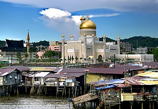
Brunei-Muara District or simply Brunei-Muara is one of the four districts of Brunei. The district borders the South China Sea to the north, Brunei Bay to the east, Limbang District of the Malaysian state of Sarawak to the south, and Tutong District to the west. It has the smallest area among the four districts, with 571 square kilometres (220 sq mi), yet is the most populous, with 289,630 people as of 2016. Bandar Seri Begawan, the country's capital, is located in this district, which is also de facto the district's capital. The district is also home Brunei International Airport, the country's only international airport, as well as Muara Port, the main and only deep-water port in the country. The Brunei River flows within this district and is home to Kampong Ayer, a historic stilt settlement directly on the river.

Serasa is a mukim or subdistrict of Brunei-Muara District in Brunei. It is headed by penghulu and is currently held by Johari bin Abdul Razak. The population was 16,173 in 2016. Serasa is home to the de facto town of Muara, and subsequently the location of Muara Port, the main shipping port of the country.
Kianggeh is a mukim (subdistrict) in the Brunei-Muara District of Brunei. It is located in the central part of the district, bordering the mukims of Berakas A and Berakas B to the north, Kota Batu to the east and south, the Kampong Ayer mukims and Lumapas to the south, Kilanas to the south-west and Gadong B to the west. Kianggeh is also part of the municipal area of Bandar Seri Begawan, the capital of Brunei. The population was 8,228 in 2016.
Berakas 'A' is a mukim or subdistrict of Brunei-Muara, Brunei. It borders the mukims of Mentiri and Berakas 'B' to the east, Kianggeh to the south, Gadong 'B' to the south-west and Gadong 'A' to the west, as well as the South China Sea to the north. The population was 27,223 in 2016. The community of Berakas 'A' is headed by a penghulu and the incumbent is Abdul Ahmad bin Husain.
Berakas 'B' is a mukim or subdistrict in the Brunei-Muara District of Brunei. It is located in the north-east centre of the Brunei-Muara district, bordering Mukim Mentiri to the north and east, Mukim Kota Batu to the east and south, Mukim Kianggeh to the south and Mukim Berakas 'A' to the west and north. The population was 40,710 in 2016. The community leader of Berakas 'B' is a penghulu and the incumbent is Pengiran Ali bin Pengiran Maon.
Kilanas is a mukim (subdistrict) in the Brunei-Muara District of Brunei. It is located in the southwestern part of the district, bordering the mukims of Gadong 'B' and Kianggeh to the north-east, Lumapas to the east and south, Pengkalan Batu to the south-west and Sengkurong to the west and north. The population was 22,492 in 2016.
Kota Batu is a mukim (subdistrict) in the Brunei-Muara District of Brunei. It is located on the southeastern part of the Brunei-Muara District, bordering the mukims of Mentiri to the north and Lumapas to the south and west, Kianggeh and the Kampong Ayer mukims to the west, as well as the Brunei Bay to the east and Pulau Limpaku Pinang in Limbang in Sarawak, Malaysia, to the east. The population was 12,935 in 2016.
Lumapas is a mukim in the Brunei-Muara district of Brunei. It is located in the south of the Brunei-Muara district, bordering the water village mukims and Mukim Kianggeh to the north, Mukim Kota Batu and Pulau Berambang to the north and east, Limbang, Sarawak (Malaysia) to the east and south, Mukim Pengkalan Batu to the west and Mukim Kilanas to the west and north. The population was 7,756 in 2016.
Pengkalan Batu or Pangkalan Batu is a mukim in Brunei-Muara District, Brunei. The population was 14,492 in 2016. It is the southernmost mukim in the district, bordering the mukims of Sengkurong to the north, Kilanas and Lumapas to the north-east, and Kiudang and Keriam in Tutong District to the south-west and north-west respectively. It also borders Limbang District in Sarawak, Malaysia to the east and south.
Sengkurong is a mukim (subdistrict) in the Brunei-Muara District of Brunei. The population was 31,493 in 2016. It is located in the western- and north-westernmost part of the district. Sengkurong faces the South China Sea to the north and borders the mukims of Gadong 'A' to the east, Kilanas to the south-east, Pengkalan Batu to the south and Keriam in Tutong District to the west.
Sungai Kebun is a mukim in the Brunei-Muara district of Brunei. It is one of the six water village mukims. The population was 4,750 in 2016. All the water village mukims are quite small in size and area and are water-bound. It is located in the heart of Brunei's capital, Bandar Seri Begawan on the waters of the Brunei river. Sungai Kebun is a part of the water village collective though it is actually considered as a mukim itself. It is adjacent to the other six water village mukims. It borders Mukim Peramu and Mukim Saba to the north, Mukim Kota Batu to the east, Mukim Lumapas to the south and west and Mukim Burong Pingai Ayer to the west and north. Awang Semaun Secondary School is located in Kampong Sungai Kebun.
Gadong 'A' is a mukim (subdistrict) in Brunei-Muara District of Brunei. The population was 34,049 in 2016.
Gadong 'B' is a mukim or subdistrict in the Brunei-Muara District of Brunei. It is located in the central western part of the Brunei-Muara district bordering the mukims of Gadong 'A' to the north, Berakas 'A' to the north-east, Kianggeh to the east and south and Kilanas to the south and west. The population was 33,637 in 2016. Gadong 'B' was previously part of the Gadong subdistrict, before it was split into two in 2007, with the other one being Gadong 'A'.

Bangar is a mukim in the Temburong District of Brunei. It is located in the north-west of the Temburong District bordering Mukim Labu to the north, Mukim Batu Apoi to the east, Mukim Amo to the south-east, Mukim Bokok to the south-west and Limbang, Sarawak (Malaysia) to the west and north. Mukim Bangar has one island within its vicinity which is Pulau Kibi. Bangar has a total area of 113 square kilometres (44 sq mi); as 2016, it had a total population of 2,449.
Labu is a mukim in Temburong District of Brunei. It is located in the north of Temburong District bordering Brunei Bay to the north, Sarawak (Malaysia) to the east, Mukim Batu Apoi to the south, Mukim Bangar to the south-west and Limbang, Sarawak (Malaysia) to the west. Mukim Labu contains several islands: Pulau Selirong, Pulau Selanjak, Pulau Siarau and Pulau Pituat. Labu has a total area of 292 square kilometres (113 sq mi); as of 2016, Labu had a total population of 590.

Mentiri, also known as Kampong Mentiri, is a village in Brunei-Muara District, Brunei. It is one of the villages under the mukim or subdistrict of the same name. The current village head is Bujang bin Sabtu. Mentiri has an area of 322.29 hectares. In 2012, it had a population of 1,121. It is also a designated postcode area with the postcode BU1929.

A village is the third and lowest administrative division of Brunei. It is headed by a village head. Villages are subdivisions of the subdistricts of Brunei. A village may have a population ranging from a few hundreds to less than ten thousand people.
Mentiri National Housing Area 'A' or Mentiri National Housing Area 1 is a village administrative division in Brunei-Muara District of Brunei. It is a village subdivision of the mukim or subdistrict of Mentiri. As a village, it is headed by a ketua kampung or village head, and the incumbent is Pengiran Aliuddin bin Pengiran Damit. It is also a designated postcode area with the postcode BU2129.
Mentiri National Housing Area 'B' or Mentiri National Housing Area 2 is a village administrative division of Brunei-Muara District, Brunei. It is a village subdivision under the mukim or subdistrict of Mentiri. As a village subdivision, it is headed by a ketua kampung or village head; the incumbent is Pengiran Ibrahim bin Pengiran Hidup. Mentiri National Housing Area 'B' is also a designated postcode area with the postcode BU2229.
Batu Marang, locally known in Malay as Kampung Batu Marang or Kampong Batu Marang, is a small stilt village in Brunei-Muara District, Brunei. It is officially a village administrative division under the mukim or subdistrict of Mentiri. As a village, it is headed by a ketua kampung or village head; the incumbent is Maidin bin Tarip. Batu Marang is also a designated postcode area with the postcode BU1529.
References
- 1 2 "Population and Housing Census Update Final Report 2016" (PDF). www.deps.gov.bn. Statistics Department. December 2018. Retrieved 27 June 2021.
Coordinates: 4°57′43″N115°01′23″E / 4.962°N 115.023°E
| | This Brunei location article is a stub. You can help Wikipedia by expanding it. |