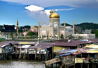
Brunei-Muara District or simply Brunei-Muara is one of the four districts of Brunei. The district borders the South China Sea to the north, Brunei Bay to the east, Limbang District of the Malaysian state of Sarawak to the south, and Tutong District to the west. It has the smallest area among the four districts, with 571 square kilometres (220 sq mi), yet is the most populous, with 289,630 people as of 2016. Bandar Seri Begawan, the country's capital, is located in this district, which is also de facto the district's capital. The district is also home Brunei International Airport, the country's only international airport, as well as Muara Port, the main and only deep-water port in the country. The Brunei River flows within this district and is home to Kampong Ayer, a historic stilt settlement directly on the river.

Muara is a town in the north-easternmost part of Brunei-Muara District, Brunei. It is officially known in Malay as Pekan Muara but is administered as a village-level subdivision under the mukim or subdistrict of Serasa. Muara has no municipal body. It is home to Muara Port, the main and only deep-water port of the country. The postcode for Muara is BT1128.

The administrative divisions of Brunei mainly consist of daerah (districts), mukim (subdistricts) and kampung or kampong (villages). They are organised hierarchically, with daerah being the first level and kampong the third level.
Tamoi is a neighbourhood in Kampong Ayer, the stilt settlement on the Brunei River in Bandar Seri Begawan, the capital of Brunei. It is officially a mukim (subdistrict) in Brunei-Muara District, as well as parts of the capital's municipal areas. The population was 1,389 in 2016. As a mukim, it is headed by a penghulu and the incumbent is Mokti bin Matsaleh.
Mentiri, also known as Kampong Mentiri, is a village in Brunei-Muara District, Brunei. It is one of the villages under the mukim or subdistrict of the same name. The current village head is Bujang bin Sabtu. Mentiri has an area of 322.29 hectares. In 2012, it had a population of 1,121. It is also a designated postcode area with the postcode BU1929.
Sengkurong is a settlement located in the eastern part of Brunei-Muara District, Brunei. It has two village-level subdivisions, namely Sengkurong 'A' and Sengkurong 'B', which are part of the Sengkurong subdistrict of the Mukims of Brunei.
Serasa is a settlement, industrial area and the main passenger gateway by sea into Brunei. It is located in the northeasternmost part of Brunei-Muara District, adjacent to the port town of Muara, some 20 kilometres (12 mi) from the capital Bandar Seri Begawan. Serasa is officially a village, the third-level subdivision of Brunei, hence the official Malay name Kampung Serasa ; it is a subdivision under the mukim or subdistrict of the same name. Serasa is home to Serasa Ferry Terminal, the main gateway for passengers and vehicles by sea, and provides connectivity mainly to Labuan, the island federal territory of Malaysia. The postcode for Serasa is BT1728.
Telisai is a coastal village in Tutong District, Brunei. Officially known in Malay as Kampung Telisai, Telisai is a village administrative division and a subdivision of the subdistrict of Telisai.
Beribi is a neighbourhood and commercial area in Bandar Seri Begawan, the capital of Brunei. It is officially a village subdivision under Gadong 'B', a mukim (subdistrict) of Brunei-Muara District. Beribi comprises the residential neighbourhood, as well as home to the Beribi Industrial area which is a dedicated site for several light industries and services-related businesses in the capital.
A village is the third and lowest administrative division of Brunei. It is headed by a village head. Villages are subdivisions of the subdistricts of Brunei. A village may have a population ranging from a few hundreds to less than ten thousand people.
Kampong Luagan Dudok is a village in the north-eastern part of Tutong District, Brunei, within the mukim (subdistrict) of Keriam. The incumbent village head is Johari bin Maidin. Kampong Luagan Dudok has an estimated population of about 980. The postcode for Kampong Luagan Dudok is TB1541.
Danau, officially known in Malay as Kampung Danau, is a coastal village in Tutong, a district of Brunei. It is a village subdivision under the mukim or subdistrict of Telisai. The population of Danau is 1,059.
Kampong Masin is a village in Pengkalan Batu, a mukim (subdistrict) in Brunei-Muara District, Brunei. The incumbent village head is Awang Moksin bin Kamis. It has the postcode BH2723.
Kampong Kulapis or Kampung Kulapis is a settlement in Brunei-Muara District, Brunei. It is officially a village-level subdivision under the mukim (subdistrict) of Sengkurong. Kampong Kulapis has an area of 4.8671 km2 (1.8792 sq mi); in 2001, it had a population of 1,166. The incumbent village head is Timor bin Limbang.
Kapok, locally known in Malay as Kampung Kapok or Kampong Kapok, is a village in Brunei-Muara District, Brunei. It has an area of 1,241.01 hectares ; the population is recorded to be 4,337. Kapok is headed by a village head and the incumbent is Marali bin Ahmad.
Lambak is a settlement on the northern outskirts of Bandar Seri Begawan, the capital of Brunei. It officially comprises two village subdivisions, namely Lambak 'A' and Lambak 'B', which are under Berakas A, a mukim (subdistrict) in Brunei-Muara District.
Madang, also known as Kampong Madang, is a neighbourhood in Bandar Seri Begawan, the capital of Brunei, as well as a village-level subdivision under Berakas 'B' of Brunei-Muara District. The head of its community is a ketua kampung or village head and the incumbent is Emran bin Ismail. The population is estimated to be 1,700. Madang is also a designated postcode area with the postcode BC3715.
Kupang is a village in Tutong District, Brunei. It is a subdivision of Keriam, a mukim (subdistrict) of the district. The community is headed by a village head and the incumbent is Puasa bin Kula. The postcode for Kupang is TB2941.
Lubok Pulau is a village in Tutong District, Brunei. It is a village subdivision under the mukim (subdistrict) of Tanjong Maya.
Sabun is a settlement in Brunei-Muara District, Brunei. It is officially a village-level subdivision in Serasa, a mukim (subdistrict) in the district. The postcode for Sabun is BT2128.
