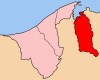
Temburong District, or simply Temburong, is the easternmost district (daerah) in Brunei. It is an exclave, as it is separated from the rest of Brunei by Malaysia and Brunei Bay, and is accessible from the mainland via the Temburong Bridge. Bangar is the town and administrative centre of the district. In 2016, Temburong had a population of 10,543.

Bangar is the town of the Bruneian district of Temburong, an isolated territorial exclave separated from the rest of the country by the Malaysian state of Sarawak. Although Bangar is officially known in Malay as Pekan Bangar, it is a village-level subdivision under the mukim or subdistrict of the same name. The postcodes for Bangar include PA1151 and PA1351.

Mukim Kuala Belait is a mukim in Belait District, Brunei. The population was 31,308 in 2016. The incumbent penghulu of Mukim Kuala Belait is Pungut bin Ali. The mukim encompasses Kuala Belait, the administrative town of the district.
Mukim Labi is a mukim in Belait District, Brunei. The population was 1,216 in 2016. The incumbent penghulu is Haji Kamarhan bin Atma, assuming office since 2003.

Serasa is a mukim or subdistrict of Brunei-Muara District in Brunei. It is headed by penghulu and is currently held by Johari bin Abdul Razak. The population was 16,173 in 2016. Serasa is home to the de facto town of Muara, and subsequently the location of Muara Port, the main shipping port of the country.
Mukim Bukit Sawat is a mukim in Belait District, Brunei. It had a population of 794 in 2016.
Kota Batu is a mukim (subdistrict) in the Brunei-Muara District of Brunei. It is located on the southeastern part of the Brunei-Muara District, bordering the mukims of Mentiri to the north and Lumapas to the south and west, Kianggeh and the Kampong Ayer mukims to the west, as well as the Brunei Bay to the east and Pulau Limpaku Pinang in Limbang in Sarawak, Malaysia, to the east. The population was 12,935 in 2016.
Pengkalan Batu or Pangkalan Batu is a mukim in Brunei-Muara District, Brunei. The population was 14,492 in 2016. It is the southernmost mukim in the district, bordering the mukims of Sengkurong to the north, Kilanas and Lumapas to the north-east, and Kiudang and Keriam in Tutong District to the south-west and north-west respectively. It also borders Limbang District in Sarawak, Malaysia to the east and south.
Kiudang is a mukim (subdistrict) in the Tutong District of Brunei. The population was 5,924 in 2016. It is headed by a penghulu and the incumbent is Abdul Rahim bin Abdullah Yakin; he is also the acting village head for Kampong Batang Mitus.

Lamunin is a mukim in the Tutong District of Brunei. It is located in the east, centre of the Tutong District, bordering Mukim Kiudang to the north, Limbang, Sarawak (Malaysia) to the east, Mukim Rambai to the south and south-west, Mukim Ukong to the west and Mukim Tanjong Maya to north-west. The population was 4,298 in 2016. The community leader for Lamunin is a penghulu and the incumbent is Tujoh bin Talip.
Rambai is a mukim in the Tutong District of Brunei. It is located in the south bordering Mukim Lamunin to the north, Limbang, Sarawak (Malaysia) to the east and south, Mukim Sukang to the south-west, Mukim Bukit Sawat to the west and Mukim Ukong to the north-west. The population was 1,404 in 2016. Mukim Rambai contain one of the largest lake within Brunei called Tasek Merimbun or Merimbun Lake and also one of the largest dam in Brunei as well, which is Empangan Air Jubli Perak Benutan or simply the Silver Jubilee Benutan Dam. It is also the country's geographical center.
Ukong is a mukim in the Tutong District of Brunei. It is located in the south-west bordering Mukim Tanjong Maya to the north-east, Mukim Lamunin to the east, Mukim Rambai to the south-east, Mukim Bukit Sawat to the south-west and Mukim Telisai to the north-west. The population was 2,272 in 2016.
Mukim Kuala Balai is a mukim in Belait District, Brunei. The population was 31 in 2016.
Melilas is a mukim in the Belait District of Brunei. It is located in the southernmost point of the Belait District, bordering Mukim Sukang to the north and Sarawak (Malaysia) to the east, south and west. The population was 29 in 2016.
Sukang is a mukim in the Belait District of Brunei. It is located in the south, centre of the Belait District, bordering Mukim Bukit Sawat to the north, Mukim Rambai to the north-east, Sarawak (Malaysia) to the east and south-east, Mukim Melilas to the south and Mukim Labi to the west. The population was 169 in 2016.

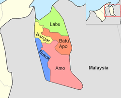
Amo is a mukim or subdistrict in the Temburong District of Brunei. It is located in the eastern part of the district, bordering the mukims of Batu Apoi to the north-east, Bokok to the west and Bangar to north-west, as well as the Malaysian state of Sarawak to the east and south. Amo has an area of 542 square kilometres (209 sq mi); as of 2016, it had a total population of 2,144.
Bangar is a mukim in the Temburong District of Brunei. It is located in the north-west of the Temburong District bordering Mukim Labu to the north, Mukim Batu Apoi to the east, Mukim Amo to the south-east, Mukim Bokok to the south-west and Limbang, Sarawak (Malaysia) to the west and north. Mukim Bangar has one island within its vicinity which is Pulau Kibi. Bangar has a total area of 113 square kilometres (44 sq mi); as 2016, it had a total population of 2,449.
Batu Apoi is a mukim in the Temburong District of Brunei. It is located in the east of the Temburong District to the centre, bordering Mukim Labu to the north, Sarawak (Malaysia) to the east, Mukim Amo to the south and Mukim Bangar to the west. Batu Apoi has a total area of 222 square kilometres (86 sq mi); as of 2016, it had a population of 1,635.
Labu is a mukim in Temburong District of Brunei. It is located in the north of Temburong District bordering Brunei Bay to the north, Sarawak (Malaysia) to the east, Mukim Batu Apoi to the south, Mukim Bangar to the south-west and Limbang, Sarawak (Malaysia) to the west. Mukim Labu contains several islands: Pulau Selirong, Pulau Selanjak, Pulau Siarau and Pulau Pituat. Labu has a total area of 292 square kilometres (113 sq mi); as of 2016, Labu had a total population of 590.

A village is the third and lowest administrative division of Brunei. It is headed by a village head. Villages are subdivisions of the subdistricts of Brunei. A village may have a population ranging from a few hundreds to less than ten thousand people.