Related Research Articles
Brunei-Muara District or simply Brunei-Muara is one of the four districts of Brunei. The district borders the South China Sea to the north, Brunei Bay to the east, Limbang District of the Malaysian state of Sarawak to the south, and Tutong District to the west. It has the smallest area among the four districts, with 571 square kilometres (220 sq mi), yet is the most populous, with 289,630 people as of 2016. Bandar Seri Begawan, the country's capital, is located in this district, which is also de facto the district's capital. The district is also home Brunei International Airport, the country's only international airport, as well as Muara Port, the main and only deep-water port in the country. The Brunei River flows within this district and is home to Kampong Ayer, a historic stilt settlement directly on the river.
Kianggeh is a mukim (subdistrict) in the Brunei-Muara District of Brunei. It is located in the central part of the district, bordering the mukims of Berakas A and Berakas B to the north, Kota Batu to the east and south, the Kampong Ayer mukims and Lumapas to the south, Kilanas to the south-west and Gadong B to the west. Kianggeh is also part of the municipal area of Bandar Seri Begawan, the capital of Brunei. The population was 8,228 in 2016.
Peramu is a neighbourhood in Kampong Ayer, the stilt settlement on the Brunei River in Bandar Seri Begawan, the capital of Brunei. It is officially a mukim (subdistrict) in Brunei-Muara District, as well as part of the capital's municipal areas. The population was 1,111 in 2016. As a mukim, it is headed by a penghulu and the incumbent is Ismit bin Naim. Peramu borders the mukims of Kianggeh to the north, Saba to the east, Sungai Kebun to the south and Burong Pingai Ayer to the west.
Saba is a neighbourhood in Kampong Ayer, the stilt settlement on the Brunei River in Bandar Seri Begawan, the capital of Brunei. It is officially a mukim (subdistrict) in Brunei-Muara District, as well as parts of the capital's municipal areas. The population was 1,000 in 2016. As a mukim, it is headed by a penghulu and the acting incumbent is Mayalin bin Saat.
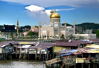
Sungai Kedayan is a mukim in the Brunei-Muara district of Brunei. It is one of the six water village mukims. The population was 230 in 2016. All the water village mukims are quite small in size and area and are water-bound. It is located in the heart of Brunei's capital, Bandar Seri Begawan on the waters of the Brunei river. Sungai Kedayan is a part of the water village collective though it is actually considered as a mukim itself. It is adjacent to the other six water village mukims. It borders Mukim Kianggeh to the north and east, Mukim Burong Pingai Ayer to the south and Mukim Tamoi to the south and west. By end-2014 - 2015, the mukim is ceased to exist because of the development of the Eco-Corridor

Serasa is a settlement, industrial area and the main passenger gateway by sea into Brunei. It is located in the northeasternmost part of Brunei-Muara District, adjacent to the port town of Muara, some 20 kilometres (12 mi) from the capital Bandar Seri Begawan. Serasa is officially a village, the third-level subdivision of Brunei, hence the official Malay name Kampung Serasa ; it is a subdivision under the mukim or subdistrict of the same name. Serasa is home to Serasa Ferry Terminal, the main gateway for passengers and vehicles by sea, and provides connectivity mainly to Labuan, the island federal territory of Malaysia. The postcode for Serasa is BT1728.

The Royal Brunei Mausoleum is a Royal Mausoleum of Brunei located at Jalan Tutong, Bandar Seri Begawan, Brunei. The Mausoleum is the main resting place and burial ground for several Sultans of Brunei and members of the Royal Family. The Royal Mausoleum was opened during the reign of Sultan Omar Ali Saifuddin I who later became the first monarch to be buried in the Mausoleum when he died in 1795.
Muda Hashim Secondary School is a government boys' secondary school in Tutong, the town of Tutong District in Brunei. The school provides five years of general secondary education leading up to O Level qualification. It has 636 students. The current principal is Mohamad Saiful Bahrin bin Sabri.

A village is the third and lowest administrative division of Brunei. It is headed by a village head. Villages are subdivisions of the subdistricts of Brunei. A village may have a population ranging from a few hundreds to less than ten thousand people.
Tungku is a populated place located on the outskirts of Bandar Seri Begawan, the capital of Brunei. It is the collective name for the village subdivision of Tungku and the public housing areas of Tungku Landless Indigenous Citizens' Housing Scheme.
Pancha Delima is a small residential neighbourhood in Bandar Seri Begawan, the capital of Brunei. It is officially a village subdivision under Berakas A, a mukim (subdistrict) of Brunei-Muara District; the incumbent ketua kampung or village head is Zulkifli bin Awang Ya'akub. The postcode for Pancha Delima is BB4513.
Orang Kaya Besar Imas is a small residential neighbourhood in Bandar Seri Begawan, the capital of Brunei. It is officially a village subdivision under Berakas A, a mukim (subdistrict) of Brunei-Muara District. The postcode for Orang Kaya Besar Imas is BB4113.
Madang, also known as Kampong Madang, is a neighbourhood in Bandar Seri Begawan, the capital of Brunei, as well as a village-level subdivision under Berakas 'B' of Brunei-Muara District. The head of its community is a ketua kampung or village head and the incumbent is Emran bin Ismail. The population is estimated to be 1,700. Madang is also a designated postcode area with the postcode BC3715.
Kiarong is a neighbourhood and commercial area in Bandar Seri Begawan, the capital of Brunei. It is officially a village subdivision under Gadong B, a mukim (subdistrict) of Brunei-Muara District. Kiarong has an area of 383.43 hectares and a population of 5,556. The community is led by a ketua kampung or village head and the incumbent is Omarsidi bin Ahmad. The postcode for Kiarong is BE1318.
Limbongan was a neighbourhood in Kampong Ayer, the riverine stilt settlement in Bandar Seri Begawan, the capital of Brunei. It was officially a village subdivision under Tamoi, a mukim (subdistrict) of Brunei-Muara District, and had the postcode BL1312. Limbongan was one of the traditional stilt neighbourhoods which had existed along the banks of the Kedayan River, a tributary of the Brunei River in the vicinity of Kampong Ayer, before they were eventually demolished in the 2010s and redeveloped into Taman Mahkota Jubli Emas, a riverfront park.
Bunut Perpindahan is a neighbourhood in Bandar Seri Begawan, the capital of Brunei. It is officially a village subdivision under Kilanas, a mukim (subdistrict) of Brunei-Muara District.
Tamoi Tengah is a small neighbourhood in Kampong Ayer, the riverine stilt settlement in Bandar Seri Begawan, the capital of Brunei. It is officially a village subdivision under Tamoi, a mukim (subdistrict) of Brunei-Muara District. The postcode for Tamoi Tengah is BL2112.
Tamoi Ujong is a small neighbourhood in Kampong Ayer, the riverine stilt settlement in Bandar Seri Begawan, the capital of Brunei. It is officially a village subdivision under Tamoi, a mukim (subdistrict) of Brunei-Muara District. The postcode for Tamoi Tengah is BL2312.
Pengiran Siraja Muda Delima Satu, commonly known as Delima Satu or Pengiran Siraja Muda, is a neighbourhood in Bandar Seri Begawan, the capital of Brunei. It is also a village subdivision under Berakas A, a mukim (subdistrict) in Brunei-Muara District. Pengiran Siraja Muda Delima Satu is primarily a residential area but also contains the commercial area of Delima, one of the commercial areas in the capital. The postcode for Pengiran Siraja Muda Delima Satu is BB5113.
Kampong Saba Ujong is a sub-neighbourhood in Kampong Ayer, the riverine stilt settlement on the Brunei River in Bandar Seri Begawan, the capital of Brunei. It is also a village in Saba, a mukim in Brunei-Muara District. The postcode for Kampong Saba Ujong is BR1726.
References
- 1 2 "Penghulu Mukim Tamoi imbau kenangan Hari Raya zaman dahulu". Media Permata Online (in Malay). 1 July 2017. Retrieved 9 August 2018.
- 1 2 (in Malay) pp 11
- ↑ "Brunei-Muara District" (PDF). www.information.gov.bn. p. 8. Retrieved 9 August 2018.
- ↑ "BANDAR SERI BEGAWAN MUNICIPAL BOARD (BOUNDARIES OF MUNICIPAL BOARD AREA) DECLARATION, 2008" (PDF). www.agc.gov.bn. Retrieved 9 August 2018.
- 1 2 "Population and Housing Census Update Final Report 2016" (PDF). www.deps.gov.bn. Statistics Department. December 2018. Retrieved 27 June 2021.
- ↑ "postcodes". post.gov.bn. Retrieved 9 August 2018.
- ↑ "A beacon of Bandar's revitalisation – Borneo Bulletin Online". Borneo Bulletin Online. 23 October 2017. Retrieved 9 August 2018.
Coordinates: 4°53′2″N114°56′9″E / 4.88389°N 114.93583°E
| | This Brunei location article is a stub. You can help Wikipedia by expanding it. |