
Mehamn is the administrative centre of Gamvik Municipality in Finnmark county, Norway. The village is located on the small Vedvik peninsula, itself part of the greater Nordkinn Peninsula, at the southern end of the Mehamnfjorden, a bay off of the Barents Sea. The village of Gamvik lies about 16 kilometres (9.9 mi) to the east and the village of Kjøllefjord lies about 30 kilometres (19 mi) to the southwest. Mehamn Chapel is located in this village. The 0.59-square-kilometre (150-acre) village has a population (2023) of 703 which gives the village a population density of 1,198 inhabitants per square kilometre (3,100/sq mi).

Tromsø Airport is an international airport located at Langnes in the city of Tromsø in Tromsø Municipality, Troms county, Norway. Situated on the western shore of the island of Tromsøya, it features a 2,447-meter (8,028 ft) runway aligned 18/36. Owned and operated by the state-owned Avinor, Langnes handled 1,910,692 passengers, 43,219 aircraft movements and 2,758 tonnes of cargo in 2014. This makes Tromsø the fifth-busiest airport in the country.

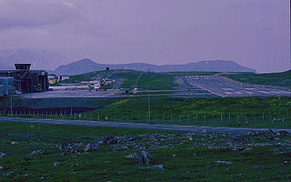
Alta Airport is an international airport in the city of Alta in Alta Municipality in Finnmark county, Norway. The airport is located at Elvebakken, 4 kilometers (2.5 mi) east of the city center. It has a single, 2,253-meter (7,392 ft) runway numbered 11/29, which lies on the southern shore of the Altafjord. Alta Airport is owned and operated by the state-owned Avinor, and served 368,393 passengers in 2014, making it the busiest airport in Finnmark.

Vadsø Airport is a regional airport in Vadsø Municipality in Finnmark county, Norway. The airport is located in the village of Kiby, 4 kilometers (2.5 mi) east of the town of Vadsø along the Varangerfjorden. The airport is operated by the state-owned Avinor and handled 77,348 passengers in 2014. The asphalt runway is 997 meters (3,271 ft) long. Services are provided by Widerøe using Dash 8-100 aircraft to other communities in Finnmark and to Tromsø International Airport. The routes are subsidized by the Ministry of Transport and Communications through public service obligations.

Haugesund Airport is an international airport serving the Haugaland region in Norway. It is located just outside the town of Haugesund on the Helganes peninsula on the island of Karmøy in the municipality of Karmøy, Rogaland county, Norway. The airport features a 2,120-meter (6,960 ft) runway aligned 13/31. Scandinavian Airlines (SAS) and Norwegian Air Shuttle provide services to Oslo. Haugesund Airport also offers discounts on international routes and has some service from low-cost carriers. The airport handled 694,005 passengers in 2014.
Honningsvåg Airport, Valan is a regional airport serving Honningsvåg in Nordkapp Municipality, Norway. The airport is located at Valan, on the south side of Skipsfjorden, 4 kilometers north of the town, and 31 km from the North Cape. The airport has a 880-by-30-meter asphalt runway which is operated by the state-owned Avinor. Flights are operated by Widerøe to Tromsø with connecting flights to Oslo. The airline also fly to other communities within Finnmark, who serve the airport with Dash 8-100 and Q200 aircraft. The airport handled 13,487 passengers in 2014.
Hammerfest Airport is a regional airport at Prærien just outside the town of Hammerfest in Hammerfest Municipality in Finnmark county, Norway. It is operated by the state-owned Avinor and handled 145,396 passengers in 2014, making it the third-busiest regional airport in the country. The airport has a 880-meter (2,890 ft) runway aligned 05/23. Services are provided by Widerøe using the Dash 8-100. Up to eight daily flights are provided to Tromsø and public service obligation flights are flown eastwards to other airports in Finnmark. The airport is the base for offshore helicopter services operated by Bristow Norway and CHC Helikopter Service. An estimated 40,000 people from Hammerfest Airport's catchment area annually use Alta Airport for flights to Oslo.

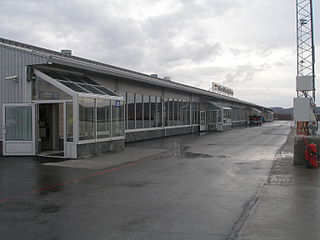
Båtsfjord Airport is a regional airport serving Båtsfjord Municipality in Finnmark county, Norway. It consists of a 1,000 by 30 meters runway and served 14,485 passengers in 2016. A further 14,663 landed and started at the airport without leaving the aircraft. Scheduled services are provided by Widerøe using the Dash 8 to Kirkenes, Hammerfest and other communities in Finnmark. The airport is owned and operated by the state-owned Avinor.
Kirkenes Airport is an international airport located at Høybuktmoen, 15 kilometers (9 mi) west of the town of Kirkenes, in Sør-Varanger Municipality in Finnmark county, Norway. Operated by the state-owned Avinor, the airport has a single 2,115-by-45-meter asphalt runway numbered 05-23. Scandinavian Airlines and Norwegian Air Shuttle operate Boeing 737-services to Oslo Airport, Gardermoen, in part generated by Høybuktmoen's function as a hub for Widerøe's regional services to other airports in eastern Finnmark. There are also summer charter flights to Central Europe to bring tourists to the Hurtigruten cruises. The airport had 297,149 passengers in 2013.

Hasvik Airport is a regional airport serving Hasvik Municipality in Finnmark county, Norway. The airport is located in the village of Hasvik on the island of Sørøya. In 2012, Hasvik Airport had 7,629 passengers, making it the third-least busy airport operated by the state-owned Avinor. The airport consists of a 909-meter (2,982 ft) runway and is served by Widerøe with Dash 8-100 aircraft. The airport tower is operated remotely from Bodø.
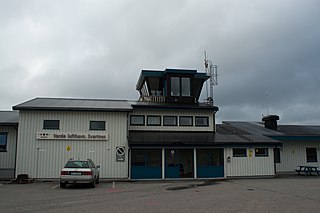
Vardø Airport is a short take-off and landing airport located at Svartnes in Vardø Municipality in Finnmark county, Norway. Owned and operated by the state-owned Avinor, it served 14,664 passengers in 2012. The airport has a 1,145-by-30-meter runway aligned 15–33. It is served by Widerøe who operate Bombardier Dash 8 aircraft to Kirkenes and other communities in Finnmark. The airport is located 4 kilometers (2.5 mi) from Vardøya and the town center of Vardø.
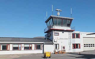
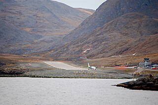
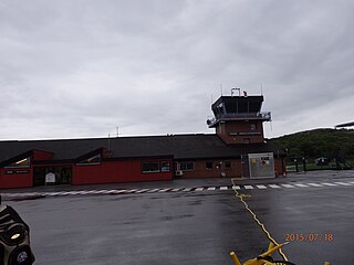
Mehamn Airport is a regional airport serving the village of Mehamn in Gamvik Municipality in Finnmark county, Norway. It also serves the villages Kjøllefjord and Gamvik. The airport is 2 kilometers (1.2 mi) outside of the village of Mehamn and is owned and operated by the state-owned Avinor. The tower is remotely controlled from Bodø.

Berlevåg Airport is a regional airport serving Berlevåg Municipality in Finnmark county, Norway. The airport is situated 2 kilometers (1.2 mi) northwest of the village of Berlevåg and is owned and operated by Avinor. The airport tower is operated remotely from Bodø.
Rørvik Airport is a regional airport located at Ryumsjøen, about 6 kilometers (4 mi) south of the town Rørvik in Nærøysund Municipality in Trøndelag County, Norway. The airport is owned and operated by the state-owned Avinor and serves Nærøysund Municipality and its surroundings. The airport has a 950-meter (3,117 ft) asphalt runway numbered 04–22. Widerøe flies to the airport with its Bombardier Dash 8 aircraft on contract with the Ministry of Transport and Communications. The airport opened in 1986 as a municipal airport. It was first served by Norving, but Widerøe took over the flights in 1988. The airport was nationalized in 1996.

Farsund Airport, Lista is an airport situated on the Lista peninsula in the municipality of Farsund in Agder county, Norway. The village of Vestbygd lies on the southwest side of the airport and the small village of Ore lies on the northeast side. The airport features a 2,990-meter (9,810 ft) concrete runway aligned 14/32. Previously it also had a 1,494-meter (4,902 ft) runway aligned 09/27. Farsund Airport, Lista is the civilian sector of the now closed Lista Air Station. Previously a regional airport, it is now only used for general aviation.

Norving A/S was a regional airline that operated in Norway between 1971 and 1993. It had roots back to the establishment of Varangfly in 1959. At its peak, the company had eight bases and 27 aircraft.

Lakselv Airport is an international airport located at Banak, 1.5 kilometers north of the village of Lakselv in Porsanger Municipality in Finnmark county, Norway. Co-located with the military Station Group Banak, the airport is owned and operated by the state-owned Avinor. The airport is also branded as North Cape Airport, although the North Cape is 190 km (120 mi) away, and the nearest airport is Honningsvåg Airport, Valan.
Gamvik Airport is a disused general aviation airport located at Slettnes, just outside the village of Gamvik in Gamvik Municipality in Finnmark county, Norway.
Båtsfjord Airport is a former regional airport located at Båtsfjorddalen just south of the village of Båtsfjord in Båtsfjord Municipality in Finnmark county, Norway. It consisted of an 800-by-30-meter gravel runway aligned 01–19 and had a simple terminal building. Construction of the airport was started a local aviation club in 1972 and was completed with a 600-meter (2,000 ft) runway in May 1973. The runway was extended the following year and in 1976 the airport was municipalized. From the start Norving operated air taxi and air ambulance flights. Following an upgraded terminal in 1978, the taxi services became scheduled and the Britten-Norman Islander was introduced to Kirkenes and Vadsø. From 1983 the Dornier 228 entered service on the Båtsfjord route.
Kautokeino Airfield is a general aviation aerodrome located in the village of Kautokeino in Kautokeino Municipality in Finnmark county, Norway. It consists of a 1,200-meter (3,900 ft) gravel runway, built by the Luftwaffe during World War II. It was rebuilt in 1958 by the Royal Norwegian Air Force to supply its radar station at Kautokeino. It is largely unused and is now owned by the Norwegian Directorate of Public Construction and Property and the Finnmark Estate. Local politicians have called for the aerodrome to be upgraded to a regional airport, but this has been rejected by Avinor.

