
Adelaide Metro is the public transport system of the Adelaide area, around the capital city of South Australia. It is an intermodal system offering an integrated network of bus, tram, and train services throughout the metropolitan area. The network has an annual patronage of 79.9 million, of which 51 million journeys are by bus, 15.6 million by train, and 9.4 million by tram. The system has evolved heavily over the past fifteen years, and patronage increased dramatically during the 2014–15 period, a 5.5 percent increase on the 2013 figures due to electrification of frequented lines.

The O-Bahn Busway is a guided busway that is part of the bus rapid transit system servicing the northeastern suburbs of Adelaide, South Australia. The O-Bahn system was conceived by Daimler-Benz to enable buses to avoid traffic congestion by sharing tram tunnels in the German city of Essen.
Guided buses are buses capable of being steered by external means, usually on a dedicated track or roll way that excludes other traffic, permitting the maintenance of schedules even during rush hours. Unlike railbuses, trolleybuses or rubber-tyred trams, for part of their routes guided buses are able to share road space with general traffic along conventional roads, or with conventional buses on standard bus lanes.

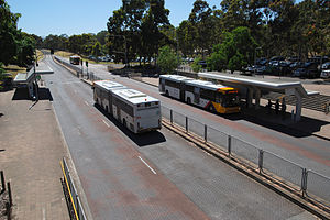
Tea Tree Plaza Interchange is a bus interchange operated by Adelaide Metro in Modbury, South Australia as part of the O-Bahn Busway. It is a central public transport hub for the north eastern suburbs of Adelaide.

Paradise Interchange is a bus interchange operated by Adelaide Metro in Paradise, South Australia as part of the O-Bahn Busway.

Greenwith is an outer-north-eastern suburb of Adelaide, the capital city of South Australia, and is within the City of Tea Tree Gully local government area. It is adjacent to Golden Grove and Salisbury Heights. Greenwith is the northernmost part of the Golden Grove urban land development.

The metropolitan area of Adelaide, South Australia is served by a wide variety of transport. Being centrally located on the Australian mainland, it forms a hub for east–west and north–south routes. The road network includes major expressways such as the Southern Expressway, the South Eastern Freeway, the Port River Expressway, the Northern Expressway and the South Road Superway. The city also has a public transport system managed by Adelaide Metro, consisting of a contracted bus system including the O-Bahn Busway, six metropolitan railway lines, and the Glenelg-Adelaide-Hindmarsh Tram. According to a study conducted by the Australian Bureau of Statistics, Adelaide has the highest passenger vehicle travel to work (84%) and the second lowest proportion of people walking to work (2.9%)–something that is being combated by the South Australian government in an effort to increase citizen ridership and use of public transport.

The Metropolitan Adelaide Transport Study, or "MATS Plan" as it became known, was a comprehensive transport plan released in 1968 proposing a number of road and rail transport projects for the metropolitan area of Adelaide, South Australia.

The State Transport Authority (STA) was the government agency which controlled public transport in South Australia between 1974 and 1994.

Northgate is a suburb in the inner north-east of Adelaide, South Australia. It is approximately a 10-minute drive from the Adelaide City Council.

Ingle Farm is an established, residential suburb, with some parklands, of about 8,500 people in the South Australian capital city of Adelaide. It is located at the base of the Mount Lofty Ranges foothills, around 12 kilometres north-east of Adelaide's central business district. It covers an area of 4.47 km2 with a population density of 19.41 people per hectare in 2001.

Mawson Lakes is a railway station and bus interchange in the Adelaide suburb of Mawson Lakes. It is located on the Gawler line, 14.3 kilometres (8.9 mi) north of Adelaide station. To the west of the station lies the Australian Rail Track Corporation standard gauge line to Crystal Brook. The northern ends of the platforms are under the Elder Smith Road bridge with elevators and stairs from the footpath down to the platforms.

Busways is an Australian bus company operating services in Sydney, and in the Central Coast, Mid North Coast regions of New South Wales and Adelaide. It is the largest privately owned bus operator in Australia.

Klemzig is a suburb of Adelaide in the City of Port Adelaide Enfield. It was the first settlement of German immigrants in Australia and was named after the village of Klemzig in what was then German Prussia and is now Klępsk in western Poland.

Torrens Transit is an Australian bus service operator in Adelaide. It operates some services as part of the Adelaide Metro network under contract to the Government of South Australia. It is a subsidiary of Transit Systems, which is a part of the Kelsian Group.

Buses in Adelaide are the most extensive service of the South Australian capital's public transport system, the Adelaide Metro. A large fleet of diesel, hybrid diesel-electric, and natural gas powered buses operate services which typically terminate in the city-centre or at a suburban interchange. Buses get priority on many roads and intersections, with dedicated bus lanes and 'B'-light bus only phases at many traffic lights.
Modbury Heights is a medium-sized suburb in the City of Tea Tree Gully, Adelaide. The suburb is located in the foothills of the Mount Lofty Ranges around 16 kilometres north east of the Central business district. Much of the suburb is residential but there is a small shopping area along Ladywood Road.

Brisbane Metro, is an under construction high-frequency bus rapid transit system that services the city of Brisbane in Queensland, Australia. It will consist of two routes that will run through the Brisbane CBD every five minutes during peak times (12bph), transporting up to 1,800 passengers per hour in each direction. The buses are expected to commence on 21 October 2024, however this will be a soft opening on the existing 169 bus route. Full service is expected to start at the end of 2024 to the beginning of 2025 on the M1 and M2 routes.