Seaford line

Last updated

Seaford railway line
Adelaide train logo.svg
Onkaparinga River train viaduct.jpg
A-City crossing the Onkaparinga River viaduct
Overview
Locale Adelaide, South Australia
Termini
Stations24
Service
Type Commuter rail
Operator(s) Adelaide Metro
Rolling stock
History
Opened
Re-sleepered
(concrete)
2009–2011
ElectrifiedJanuary 2013–14
Technical
Line length35.9 km (22.3 mi)
Number of tracks 2
Track gauge 1,600 mm (5 ft 3 in)
Electrification 25 kV 50 Hz AC from overhead catenary
Route map

Contents

km
BSicon KBHFa.svg
0
Adelaide Adelaide tram logo.svg Adelaide bus logo.svg
BSicon dCONTgq-.svg
BSicon udvCONTgq.svg
BSicon exv-STR+rg.svg
BSicon STRr-.svg
BSicon SHI1l.svg
BSicon uvSTR+rf-.svg
BSicon udSTR.svg
BSicon edABZgl.svg
BSicon exdKDSTeq.svg
Adelaide Depot
closed 2011
BSicon lvMKRZu.svg
BSicon RGq.svg
BSicon umvSTR.svg
BSicon umvSKRZ-G4o.svg
Glover Avenue
BSicon exCONTgq.svg
BSicon uemdKRZ.svg
BSicon edABZgr.svg
BSicon umvSTR-HST.svg
2.0
Mile End
BSicon lvMKRZu.svg
BSicon RGq.svg
BSicon umvSTR.svg
BSicon exlv-HST.svg
BSicon umvSTR.svg
2.9
Mile End Goods
closed 1994
BSicon umvBHF-STR.svg
Adelaide Parklands Terminal BSicon LDER.svg
BSicon exlv-HST.svg
BSicon umvSTR.svg
Keswick
closed 2013
BSicon lvMKRZu.svg
BSicon RGq.svg
BSicon umvSTR.svg
BSicon umvSTR-BHF.svg
4.0
Adelaide Showground
BSicon exlv-HST.svg
BSicon umvSTR.svg
Showground Central
2003–2013
BSicon umvBUE.svg
Leader Street
BSicon uedINT-L.svg
BSicon dINT-R.svg
5.0
Goodwood
BSicon uCONTgq.svg
BSicon udKRZlu.svg
BSicon mdKRZru.svg
BSicon uCONTfq.svg
BSicon uv-STR.svg
BSicon vSHI2gl-.svg
BSicon umvBUE.svg
BSicon dSKRZ-G2u.svg
Victoria Street
BSicon v-STRlg.svg
BSicon uvSTRlf-.svg
BSicon ldMKRZvu.svg
BSicon dSTRq-.svg
BSicon ud-STRq.svg
BSicon dSTR.svg
BSicon dCONTfq-.svg
BSicon udvCONTfq.svg
BSicon v-SHI2r.svg
BSicon BUE.svg
East Avenue
BSicon HST.svg
6.3
Clarence Park
BSicon HST.svg
7.1
Emerson
BSicon hSTRaeq.svg
BSicon RGq.svg
BSicon BUE.svg
Australian Alphanumeric State Route A3.svg Cross Road (level crossing)
Australian Alphanumeric State Route A2.svg South Road (overpass)
BSicon HST.svg
7.9
Edwardstown
BSicon BUE.svg
De Laine Avenue
BSicon BUE.svg
Angus Avenue
BSicon BUE.svg
Raglan Avenue
BSicon INT.svg
9.1
Woodlands Park Adelaide bus logo.svg
BSicon BUE.svg
Dunorlan Road
BSicon ABZgl.svg
BSicon CONTfq.svg
BSicon HST.svg
10.2
Ascot Park
BSicon hSKRZ-G4a.svg
BSicon MSTR.svg
BSicon hSTRe@f.svg
BSicon RGq.svg
BSicon HST.svg
11.4
Marion
BSicon WBRUCKE1.svg
BSicon eHST.svg
Oaklands (original site)
1913–2008
BSicon BHF.svg
12.9
Oaklands Adelaide bus logo.svg
BSicon SKRZ-G4u.svg
Diagonal Road/Morphett Road
BSicon HST.svg
13.7
Warradale
BSicon HST.svg
14.6
Hove
BSicon BUE.svg
BSicon RGq.svg
Australian Alphanumeric State Route A15.svg Brighton Road
BSicon BUE.svg
Jetty Road
BSicon eHST.svg
Brighton (original site)
1913–1976
BSicon BHF.svg
16.0
Brighton Adelaide bus logo.svg
BSicon BUE.svg
Edwards Street
BSicon BUE.svg
Shoreham Road
BSicon eHST.svg
South Brighton
closed 1976
BSicon HST(R).svg
17.1
Seacliff (to Adelaide) Adelaide bus logo.svg
BSicon BUE.svg
Wheatland Road
BSicon HST(L).svg
17.2
Seacliff (to Seaford)
BSicon BUE.svg
Maitland Terrace
BSicon SKRZ-G2u.svg
Singleton Road
BSicon HST.svg
18.3
Marino Adelaide bus logo.svg
BSicon BUE.svg
Jervois Terrace
BSicon HST.svg
18.9
Marino Rocks
BSicon BHF.svg
21.4
Hallett Cove Adelaide bus logo.svg
BSicon eKRWgl.svg
BSicon exKRW+r.svg
BSicon STR.svg
BSicon exHST.svg
Hallett Cove (original site)
1915–1974
BSicon STR.svg
BSicon exLSTRe.svg
BSicon SKRZ-G2u.svg
The Cove Road
BSicon HST.svg
22.9
Hallett Cove Beach Adelaide bus logo.svg
BSicon SKRZ-G2u.svg
Grand Central Avenue
BSicon SKRZ-G2u.svg
Meyer Road
BSicon BUE.svg
Christie Road
BSicon SPLa.svg
BSicon exv-SHI2+l.svg
BSicon vSTR.svg
BSicon evSHI2gr-.svg
BSicon exv-KDSTe.svg
BSicon vSTR.svg
Port Stanvac siding
BSicon vDST-STR.svg
Lonsdale Depot
BSicon SPLe.svg
BSicon HST.svg
26.7
Lonsdale
BSicon SKRZ-Go.svg
Australian Alphanumeric State Route A15.svg Dyson Road
BSicon SKRZ-G2u.svg
O'Sullivan Beach Road
BSicon WBRUCKE1.svg
Christie Creek
BSicon hSKRZ-G4haeo.svg
Flaxmill Road
BSicon HST.svg
28.9
Christie Downs
BSicon SKRZ-G2u.svg
Elizabeth Road
BSicon eHST.svg
Christie Downs (original site)
1976–81
BSicon SKRZ-G2u.svg
Beach Road
BSicon SKRZ-G2u.svg
Hannah Road
BSicon BHF.svg
30.2
Noarlunga Centre Adelaide bus logo.svg
BSicon SKRZ-G4u.svg
Goldsmith Drive
BSicon hSKRZ-G4haeo.svg
Old Honeypot Road
BSicon hSKRZ-G2a.svg
River Road
BSicon hKRZWe.svg
BSicon SPLa.svg
BSicon vSTR-DST.svg
Seaford Meadows Depot
BSicon SPLe.svg
BSicon exLSTRa.svg
BSicon dHST.svg
BSicon exv-SHI2r.svg
34.7
Seaford Meadows
BSicon dSKRZ-G2u.svg
BSicon exdSTR.svg
Seaford Road
BSicon dSKRZ-G2u.svg
BSicon exdSTR.svg
Lynton Terrace
BSicon dKBHFe.svg
BSicon tdSTR.svg
BSicon exdSTR.svg
36.0
Seaford Adelaide bus logo.svg Adelaide metro regional bus icon.png
BSicon tvSHI2l-.svg
BSicon exv-SHI2r.svg
BSicon tv-SHI2r.svg
BSicon exvSTRl-.svg
BSicon exdCONTfq.svg
BSicon tCONTf.svg
corridor for future extension to Aldinga

BSicon STRq.svg
BSicon exSTRq.svg
BSicon uSTRq.svg
BSicon uexSTRq.svg

The Seaford railway line is a suburban commuter line in Adelaide, South Australia.

History

Before the extension of the line to Noarlunga Centre in 1978, the Willunga line ran from Hallett Cove station on a different route through Reynella, Morphett Vale and Hackham to Willunga (south-east of Noarlunga). It closed in 1969 and in September 1972 a track-removal train removed the tracks, and for six years Noarlunga had no train service.

The South Australian Railways and its successor, the State Transport Authority, extended the current railway southwards in stages from Hallett Cove to cater for increasing residential development in the southern area. Opening dates for passenger services were: Hallett Cove Beach on 30 June 1974; Christie Downs on 25 January 1976 (This was a temporary terminus just north of Beach Road and adjacent to Hyacinth Crescent, and was in a different location to the current Christie Downs station, which opened in November 1981.); and Noarlunga Centre on 2 April 1978.

Prior to 2014, most trains were operated by 3000 class railcars augmented at times by 2000 class railcars. Since the electrification of the line, the latter are no longer authorised to operate on the line. [1] Most services are now operated by A-City electric multiple units. A number of railcars needed for peak-hour services are now stabled overnight in secure sidings at Port Stanvac, north of Lonsdale station, and at a much bigger facility adjacent to Seaford Meadows. The last freight trains on the line, to and from Port Stanvac Refinery, ceased in the late 1990s.

Re-sleepering and electrification

In 2008, the State Government announced a plan to upgrade and electrify the Seaford line with the Federal Government also to provide funding. [2] In December 2009, Stage 1 of the Noarlunga line upgrade was completed between Adelaide and Brighton. [3] This work saw the track removed, with the track bed and track renewed. Dual gauge sleepers were laid to allow for the line to be converted to standard gauge at a future date. Stage 2 commenced in February 2011 with the line closed for six months and continued the upgrade works between Oaklands and Noarlunga. [4] Most stations (Brighton, Seacliff, Marino, Marino Rocks and Lonsdale) received a minor upgrade due to the presence of asbestos in many station shelters, necessitating their replacement.

On 2 January 2013, the line closed to allow for its electrification and extension, with trains being replaced by bus services. [5] Rail services resumed on 1 December 2013. [6] The completed project was opened by the South Australian Transport and Infrastructure Minister Tom Koutsantonis on 18 January 2014. [7] Electric train services commenced in February 2014 after testing was completed on the line. [8] [9] At the time, only four A-City electric multiple units had entered service, so most services continued to be operated by 3000 class railcars.

Seaford extension

The 1.2km railway overpass over the Onkaparinga River Seaford Railway Bridge (48735386217).jpg
The 1.2km railway overpass over the Onkaparinga River

In 2005, the State Government announced the line would be extended 5.5 kilometres (3.4 mi) to the southern suburb of Seaford. The plan was cancelled in December 2007 after a study concluded that the extension could not be justified. The government announced that it would retain the corridor to Aldinga for a possible extension further south in the future. [10] In July 2008, a feasibility study was commissioned by the government into extending the line. [11] This extension was given approval after the Federal Government announced a $291 million investment in the project as part of the 2009/10 Federal Budget. [12]

Construction started in 2011 with the extension opening on 23 February 2014. [8] [9] The extension included a new 1.2-kilometre (0.75 mi) elevated rail bridge over the Onkaparinga River, a rail bridge over Old Honeypot Drive, and new railway stations at Seaford Meadows and Seaford. New road bridges were also constructed over the extension at Goldsmith Drive, Seaford Road and Lynton Terrace. [13] [14] [15] [16] [17]

Future extension to Aldinga Beach

In 2019, Renewal SA delivered a Draft Structure Plan of a 94 hectare area of land in Aldinga which is set to include a new school and a train station. [18]

Route

The line runs south from Adelaide station paralleling the Belair line as far as Goodwood. It then branches off in a south-west direction through the suburbs of Edwardstown, Oaklands Park and Marion to the coast at Brighton, where it turns south towards Noarlunga Centre in the southern suburbs. The line was known as the Marino and Hallett Cove line when it finished at Hallett Cove. Most trains terminated at Marino, with only about a quarter going to Hallett Cove.

Like the rest of the Adelaide network, the line is broad gauge. Dual gauge sleepers have been laid to allow for the line to be converted to standard gauge at a future date. [19] The line is 35.9 kilometres (22.3 mi) long and is the second longest of the Adelaide suburban railway lines. The line is double track throughout. The Australian Rail Track Corporation standard-gauge main line passes over the line just south of Goodwood station, and the Flinders line branches off south of Woodlands Park.

Line guide

Seaford Line
NameDistance from
Adelaide
Year openedServing suburbsConnections
Adelaide 0.0 km1856Adelaide Belair Flinders Gawler
Grange Outer Harbor

Adelaide bus logo.svg Bus Adelaide tram logo.svg Tram

Mile End 2.0 km1898Mile End
Adelaide Showground 4.0 km2014Keswick, Wayville
Goodwood 5.0 km1883Forestville, Goodwood Belair
Clarence Park 6.3 km1913Black Forest, Clarence Park Adelaide bus logo.svg Bus
Emerson 7.1 km1928Black Forest, Clarence Park
Edwardstown 7.9 km1913Edwardstown
Woodlands Park 9.1 km1925Ascot Park, Edwardstown Flinders

Adelaide bus logo.svg Bus

Ascot Park 10.2 km1914Ascot Park
Marion 11.4 km1954Marion
Oaklands 12.9 km1913Oaklands Park, Warradale Adelaide bus logo.svg Bus
Warradale 13.7 km1956Warradale
Hove 14.6 km1914Hove
Brighton 16.0 km1913Brighton Adelaide bus logo.svg Bus
Seacliff 17.0 km1915Seacliff Adelaide bus logo.svg Bus
Marino 18.3 km1913Kingston Park, Marino Adelaide bus logo.svg Bus
Marino Rocks 18.9 km1915Marino
Hallett Cove 21.4 km1915Hallett Cove Adelaide bus logo.svg Bus
Hallett Cove Beach 22.9 km1974Hallett Cove Adelaide bus logo.svg Bus
Lonsdale 26.7 km1976Lonsdale
Christie Downs 28.9 km1976Christie Downs
Noarlunga Centre 30.2 km1978Noarlunga Centre Adelaide bus logo.svg Bus
Seaford Meadows 34.7 km2014Seaford Meadows
Seaford 36.0 km2014Seaford Adelaide bus logo.svg Bus Adelaide metro regional bus icon.png Regional Coach

Former stations

Services

3000 class railcar on the Seaford line before it was electrified NoarlungaRailLine.jpg
3000 class railcar on the Seaford line before it was electrified

Trains to and from Adelaide operate every 5–10 minutes during the weekday peak periods, every 10–20 minutes off-peak on weekdays, and every 30 minutes on weekends plus in the late evening. Previously, some stations were also serviced by trains from Brighton and from the Flinders branch line on weekdays. [20]

Related Research Articles

<span class="mw-page-title-main">Adelaide Metro</span> Public transport system in Adelaide, Australia

Adelaide Metro is the public transport system of Adelaide, the capital city of South Australia. It is an intermodal system offering an integrated network of bus, tram, and train services throughout the metropolitan area. The network has an annual patronage of 79.9 million, of which 51 million journeys are by bus, 15.6 million by train, and 9.4 million by tram. The system has evolved heavily over the past fifteen years, and patronage increased dramatically during the 2014–15 period, a 5.5 percent increase on the 2013 figures due to electrification of frequented lines.

<span class="mw-page-title-main">Goodwood railway station</span> Railway station in Adelaide, South Australia

Goodwood railway station is the junction station for the Belair, Seaford and Flinders lines. The Belair line diverges south-east towards Millswood, while the Seaford and Flinders lines diverge south-west towards Clarence Park. The Glenelg tram line crosses over the railway lines at the south end of Goodwood station. The station services the Adelaide inner-southern suburb of Goodwood, and is 5.0 km from Adelaide station.

<span class="mw-page-title-main">Marino railway station, Adelaide</span> Railway station in Adelaide, South Australia

Marino railway station is located on the Seaford line. Situated in the southern Adelaide suburb of Marino, it is 18.3 kilometres from Adelaide station.

<span class="mw-page-title-main">TransAdelaide</span> Government transport organisation in Adelaide in South Australia

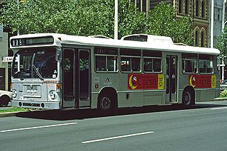
TransAdelaide was a publicly owned corporation established in July 1994, which provided suburban train, tram and bus services in Adelaide, South Australia, under contract to the Government of South Australia. It took over these responsibilities from the State Transport Authority.

<span class="mw-page-title-main">Railways in Adelaide</span> Regional rail network

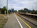
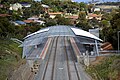
The rail network in Adelaide, South Australia, consists of four lines and 89 stations, totalling 132 km (82 mi). It is operated by Keolis Downer under contract from the Government of South Australia, and is part of the citywide Adelaide Metro public transport system.

<span class="mw-page-title-main">Rail transport in South Australia</span> Rail transport in South Australia

The first railway in colonial South Australia was a line from the port of Goolwa on the River Murray to an ocean harbour at Port Elliot, which first operated in December 1853, before its completion in May 1854.

<span class="mw-page-title-main">Ascot Park railway station</span> Railway station in Adelaide, South Australia

Ascot Park railway station is located on the Seaford line. Situated in the south-western Adelaide suburb of Ascot Park, it is 10.2 kilometres from Adelaide station.
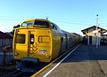
<span class="mw-page-title-main">Belair line</span> Rail line in Adelaide, South Australia

<span class="mw-page-title-main">Flinders line</span> Railway line in Adelaide, South Australia

The Flinders railway line is a suburban commuter line in Adelaide, South Australia, that branches off the Seaford line at Mitchell Park, and ends opposite Science Park, close to the Flinders University and the Flinders Medical Centre. The line is single track for most of its length, from Celtic Avenue, near Mitchell Park station, to its terminus.

<span class="mw-page-title-main">Marino Rocks railway station</span> Railway station in Adelaide, South Australia

Marino Rocks railway station is located on the Seaford line. Situated in the southern Adelaide suburb of Marino, it is 18.9 kilometres from Adelaide station and leads directly into Nimboya Road Reserve and park.

<span class="mw-page-title-main">Hallett Cove railway station</span> Railway station in Adelaide, South Australia

Hallett Cove railway station is located on the Seaford line. Situated in the southern Adelaide suburb of Hallett Cove, it is 21.4 kilometres from Adelaide station.

<span class="mw-page-title-main">Hallett Cove Beach railway station</span> Railway station in Adelaide, South Australia

Hallett Cove Beach railway station is located on the Seaford line. Situated in the southern Adelaide suburb of Hallett Cove, it is 22.9 kilometres from Adelaide station.

<span class="mw-page-title-main">Christie Downs railway station</span> Railway station in Adelaide, South Australia

Christie Downs railway station is located on the Seaford line. Situated in the southern Adelaide suburb of Christie Downs, it is 28.9 kilometres from Adelaide station.

<span class="mw-page-title-main">State Transport Authority (South Australia)</span> Agency responsible for public transport in South Australia

The State Transport Authority (STA) was the government agency which controlled public transport in South Australia between 1974 and 1994.

<span class="mw-page-title-main">Noarlunga Centre railway station</span> Railway station and bus interchange in Adelaide, South Australia

Noarlunga Centre railway station is a railway station on the Seaford line, and for almost 36 years it was the terminus of the line. Situated in the southern Adelaide suburb of Noarlunga Centre, it is 30.2 kilometres from Adelaide station. The station has a bus interchange directly alongside and is adjacent to a large commuter park & ride facility.

<span class="mw-page-title-main">Seaford Meadows railway station</span> Railway station in Adelaide, South Australia

Seaford Meadows railway station is located on the Seaford line in South Australia. Situated in the southern Adelaide suburb of Seaford Meadows, it is 34.7 kilometres from Adelaide station.

<span class="mw-page-title-main">Seaford railway station, Adelaide</span> Railway station in Adelaide, South Australia

Seaford railway station is the terminus of the Seaford line in South Australia. Situated in the southern Adelaide suburb of Seaford, it is 35.9 kilometres from Adelaide station.

<span class="mw-page-title-main">Adelaide Metro 4000 class</span> Class of electric multiple unit trains

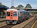
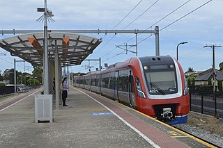
The Adelaide Metro 4000 class, also referred to as A-City trains, are electric multiple unit trains built by Bombardier Transportation in Dandenong, Victoria for the electrified Adelaide rail network. They are the only class of operational electric trains in South Australia, running services on the Gawler, Seaford and Flinders lines.

References

  1. "Limited life for 2000 class Jumbo railcars" Railway Digest January 2015 page 20
  2. 2008/09 State Budget South Australian Department of Treasury & Finance June 2008
  3. Noarlunga Rail Revitalisation Schedule Department of Transport, Energy & Infrastructure
  4. Schedule Department of Planning, Transport & Infrastructure
  5. Noarlunga & Tonsley lines closed Adelaide Metro
  6. "Rail services resume on Noarlunga line" Railway Digest January 2014 page 23
  7. Wills, Daniel (19 January 2014). "Transport and Infrastructure Minister Tom Koutsantonis turns on new electric Noarlunga train lines".
  8. 1 2 Rail revitalistaion Seaford rail extension Department of Planning, Transport & Infrastructure
  9. 1 2 Electrifying opening for the new Seaford line ABC Adelaide 23 February 2014
  10. No rail service for Seaford ABC News 19 December 2007
  11. Government looks at extending Noarlunga, Tonsley rail lines Adelaide Advertiser 3 July 2008
  12. 2009-10 Budget Archived 14 May 2009 at the Wayback Machine Federal Government May 2009
  13. Features & benefits Archived 29 March 2014 at archive.today Department of Planning, Transport & Infrastructure
  14. Seaford rail extension moves forward as planning contracts awarded Anthony Albanese 12 August 2009
  15. Work starts on Seaford rail extension Projectlink 4 September 2009
  16. Seaford Rail Extension Project Adcor Constructions
  17. Seaford Rail Extension Thiess
  18. "Development of Aldinga train station inches closer". Victor Harbour Times. 29 May 2019. Retrieved 1 November 2019.
  19. The gauge problems lives on Archived 29 November 2014 at the Wayback Machine 21 March 2012
  20. Seaford & Tonsley timetable Adelaide Metro 20 July 2014