
Port Adelaide station is a railway station located on the Outer Harbor line. Situated in the north-western Adelaide suburb of Alberton, it is 11.7 kilometres from Adelaide station.

Woodville railway station is the junction station for the Grange and Outer Harbor lines with the lines diverging immediately north of the station. Situated in the western Adelaide suburb of Woodville, it is 7.5 kilometres from Adelaide station. It has auto pedestrian gates and lights. Platform 3 had a small kiosk, built around 2006, that sells refreshments and tickets, but has not been opened since 2009.

Bowden railway station is located on the Grange, Port Dock, and Outer Harbor lines. Situated in the inner-city Adelaide suburb of Bowden, it is 2.7 kilometres from Adelaide station. The station was rebuilt and reopened in January 2018, with the original platforms closed and demolished; the southbound platform was closed and demolished in April 2017, a section of the northbound platform was retained due to the original station's 1856 brick and stone station building being located on that platform, which now houses The Loose Caboose Café.

Alberton railway station is the junction station for the Port Dock and Outer Harbor lines. Situated in the north-western Adelaide suburb of Alberton, it is 10.2 kilometres from Adelaide station. The station is listed on the South Australian Heritage Register.
Port Dock railway station – named Port Adelaide until 1916 – is the terminus of the Port Dock line, located on Baker Street, Port Adelaide. The first station was located in the commercial centre at the corner of St Vincent Street and Lipson Street and served as the original terminus of the railway between Adelaide and Port Adelaide, which opened in 1856.

Ethelton station is located on the Outer Harbor line. Situated in the north-western Adelaide suburb of Ethelton, it is 13.1 kilometres from Adelaide station. The station is currently closed for reconstruction.

The Dry Creek–Port Adelaide railway line is an eight-kilometre east–west freight railway line running through Adelaide's north-western suburbs. The line is managed by the Australian Rail Track Corporation (ARTC) and is an important link between Port Adelaide, Pelican Point and the main interstate rail routes which link Adelaide with Melbourne, Perth, Darwin and Sydney. Prior to 1988, a limited local passenger service operated, stopping at five intermediate stations along the line. Since May 1988, the line has been freight-only.

The Outer Harbor line is a suburban branch line in Adelaide, South Australia. It runs from Adelaide station through the north western suburbs to Port Adelaide and Outer Harbor. It is 21.9 kilometres (13.6 mi) in length, and shares part of its run with the Grange and Port Dock lines. It is operated by Adelaide Metro.

The Grange line is a suburban branch line in Adelaide, South Australia.
South Road and its southern section as Main South Road outside of Adelaide is a major north–south conduit connecting Adelaide and the Fleurieu Peninsula, in South Australia. It is one of Adelaide's most important arterial and bypass roads. As South Road, it is designated part of route A2 within suburban Adelaide. As Main South Road, it is designated part of routes A13 and B23.

Largs railway station is located on the Outer Harbor line. Situated in the north-western Adelaide suburb of Largs Bay, it is 15.5 kilometres from Adelaide station.

Peterhead railway station is located on the Outer Harbor line. Situated in the north-western Adelaide suburb of Peterhead, it is 14.6 kilometres from Adelaide station.

Glanville railway station is located on the Outer Harbor line. Situated in the north-western Adelaide suburb of Glanville, it is 13.8 kilometres from Adelaide station.

Cheltenham railway station is located on the Port Dock and Outer Harbor lines. Situated in the north-western Adelaide suburb of Cheltenham, it is 9.2 kilometres (5.7 mi) from Adelaide station.

East Grange railway station is located on the Grange line. Situated in the western Adelaide suburb of Grange, it is 12 kilometres from Adelaide station.

West Croydon railway station is located on the Grange, Port Dock, and Outer Harbor lines. Situated in the western Adelaide suburb of West Croydon, it is 5.1 kilometres from Adelaide station.

Ovingham railway station is located on the Gawler line. Situated in the inner northern Adelaide suburb of Ovingham, it is located 3.6 kilometres (2.2 mi) from Adelaide station.
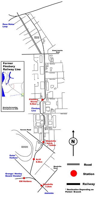
The Finsbury railway line is a defunct railway in north western Adelaide which was used mainly for industrial purposes in the 20th century. It ran through the suburbs of Woodville, Woodville North, Pennington and Ottoway, connecting the Outer Harbor line with the Dry Creek-Port Adelaide line. It serviced four stations; Actil, Woodville North, No. 18 Shed, and Finsbury Stores. It closed in 1979 and was dismantled in 1985.
Torrens Bridge railway station was a short-lived railway station on the Outer Harbor line in North Adelaide. The location of the station was east of Bonython Park. It was located about 1.7 kilometres (1.1 mi) from Adelaide station.
The Adelaide–Port Augusta railway line is the main route for northbound rail traffic out of Adelaide, South Australia. The line, 315 kilometres long, is part of the Adelaide–Darwin rail corridor and the Sydney–Perth rail corridor.
