Bowden railway station

Last updated

Bowden
New Bowden Station.jpg
The new Bowden station in December 2018.
General information
LocationGibson Street, Bowden
Coordinates 34°54′22″S138°34′33″E / 34.9061°S 138.5757°E / -34.9061; 138.5757
Owned by Department for Infrastructure & Transport
Operated by Adelaide Metro
Line(s) Outer Harbor
Grange
Distance2.7 km from Adelaide
Platforms2
Tracks2
Connections Adelaide bus logo.svg Bus
Adelaide tram logo.svg Tram
Construction
Structure typeLowered
ParkingNo
Bicycle facilitiesYes
AccessibleYes → level boarding
Other information
Station code16496 (to City)
18442 (to Outer Harbor & Grange)
Website Adelaide Metro
History
Opened1856
Rebuilt2018
Services
Preceding station Adelaide Metro Following station
Adelaide
Terminus
Grange line Croydon
towards Grange
Outer Harbor line Croydon
towards Outer Harbor

Bowden railway station is located on the Grange and Outer Harbor lines. [1] Situated in the inner-city Adelaide suburb of Bowden, it is 2.7 kilometres from Adelaide station. The station was rebuilt and reopened in January 2018, with the original platforms closed and demolished; the southbound platform was closed and demolished in April 2017, a section of the northbound platform was retained due to the original station's 1856 brick and stone station building being located on that platform, which now houses The Loose Caboose Café.

Contents

History

Bowden was one of the original stations on the Adelaide to Port Adelaide railway when the line opened in April 1856. In 1871, sidings were constructed at the Woodville end of the station for delivery of coal from Port Adelaide to the adjacent gas works. With increasing traffic, the single track Adelaide to Port Adelaide line was duplicated in 1881, and the sidings at Bowden were extended as the gas works grew. Two signal cabins were in operation at Bowden between 1884 and 1930, one at East Street (at the Woodville end), the second at Gibson Street (at the Adelaide end). The East Street cabin was closed when colour light signalling was introduced on the Port line in the 1930s.

The SA Gas Company sidings were closed in June 1973 and Bowden's goods yard was closed completely from September 1977 along with the Gibson Street signal cabin. The site of the gas works sidings is still visible on the north side of the line near the Chief Street underpass. With falling passenger numbers, the station has been unattended since November 1979, which is in marked contrast from the middle years of the 20th century when usage was high enough to justify staffed ticket offices on both platforms. In 2012, The Loose Caboose Café was opened in the station building on northbound platform 1. [2] In late 2016, the station was ranked as one of the better stations in the western suburbs based on 5 criteria. [3]

Redevelopment

Bowden station was significantly redeveloped as a part of the Torrens Rail Junction Project, a grade separation project to lower the Outer Harbor and Grange lines below Park Terrace, the Adelaide-Port Augusta line and Gawler line. The original city-bound platform was closed on 11 April 2017 and demolished shortly afterwards. The outbound platform was closed in September of the same year along with the entire Outer Harbor and Grange lines to facilitate main construction of the rail junction; this platform and the heritage station building containing The Loose Caboose Café were retained and the platform is now in use as a pedestrian walkway. [4] The new Bowden station was constructed between Park Terrace and Gibson Street in the lowered cutting and was opened on 15 January 2018 along with the Outer Harbor and Grange lines. [5]

Services by platform

PlatformLinesDestinations
1 Grange all stops services to Grange
Outer Harbor all stops services to Outer Harbor
2 Grange all stops services to Adelaide
Outer Harbor all stops services to Adelaide

Transport Connections

The closest bus stop to Bowden station is Stop 6 on Port Road: [6] [7]
150 City – Osborne
155 City – Westfield West Lakes
157 City – Largs Bay

Bowden station is also in close proximity to the Entertainment Centre tram station:

Glenelg Entertainment Centre – Moseley Square (peak hour only)
Glenelg Entertainment Centre – Botanic Garden

Related Research Articles

<span class="mw-page-title-main">Adelaide Metro</span> Public transport system in Adelaide, Australia

Adelaide Metro is the public transport system of Adelaide, the capital city of South Australia. It is an intermodal system offering an integrated network of bus, tram, and train services throughout the metropolitan area. The network has an annual patronage of 79.9 million, of which 51 million journeys are by bus, 15.6 million by train, and 9.4 million by tram. The system has evolved heavily over the past fifteen years, and patronage increased dramatically during the 2014–15 period, a 5.5 percent increase on the 2013 figures due to electrification of frequented lines.

<span class="mw-page-title-main">Adelaide railway station</span> Railway station in Adelaide, South Australia

Adelaide railway station is the central terminus of the Adelaide Metro railway system. All lines approach the station from the west, and it is a terminal station with no through lines, with most of the traffic on the metropolitan network either departing or terminating here. It has nine below-ground platforms, all using broad gauge track. The station is located on the north side of North Terrace, west of Parliament House.

<span class="mw-page-title-main">Port Adelaide railway station</span> Railway station in Adelaide, South Australia

Port Adelaide station is a railway station located on the Outer Harbor line. Situated in the north-western Adelaide suburb of Alberton, it is 11.7 kilometres from Adelaide station.

<span class="mw-page-title-main">Woodville railway station, Adelaide</span> Railway station in Adelaide, South Australia

Woodville railway station is the junction station for the Grange and Outer Harbor lines with the lines diverging immediately north of the station. Situated in the western Adelaide suburb of Woodville, it is 7.5 kilometres from Adelaide station. It has auto pedestrian gates and lights. Platform 3 had a small kiosk, built around 2006, that sells refreshments and tickets, but has not been opened since 2009.

<span class="mw-page-title-main">Railways in Adelaide</span> Regional rail network

The rail network in Adelaide, South Australia, consists of four lines and 89 stations, totalling 132 km (82 mi). It is operated by Keolis Downer under contract from the Government of South Australia, and is part of the citywide Adelaide Metro public transport system.

<span class="mw-page-title-main">Alberton railway station, Adelaide</span> Railway station in Adelaide, South Australia

Alberton railway station is located on the Outer Harbor line. Situated in the north-western Adelaide suburb of Alberton, it is 10.2 kilometres from Adelaide station. The station is listed on the South Australian Heritage Register.

<span class="mw-page-title-main">Port Dock railway station</span> Former terminus of the railway between Adelaide and Port Adelaide

Port Dock railway station – named Port Adelaide until 1916 – was located in the commercial centre of Port Adelaide, South Australia at the corner of St Vincent Street and Lipson Street. It was the original terminus of the railway between Adelaide and Port Adelaide, which opened in 1856.

<span class="mw-page-title-main">Kilkenny railway station, Adelaide</span> Railway station in Adelaide, South Australia

Kilkenny railway station is located on the Grange and Outer Harbor lines. Situated in the western Adelaide suburb of Kilkenny, it is six kilometres from Adelaide station.

<span class="mw-page-title-main">Dry Creek–Port Adelaide railway line</span> Railway line in Adelaide, South Australia

The Dry Creek–Port Adelaide railway line is an eight-kilometre east–west freight railway line running through Adelaide's north-western suburbs. The line is managed by the Australian Rail Track Corporation (ARTC) and is an important link between Port Adelaide, Pelican Point and the main interstate rail routes which link Adelaide with Melbourne, Perth, Darwin and Sydney. Prior to 1988, a limited local passenger service operated, stopping at five intermediate stations along the line. Since May 1988, the line has been freight-only.

<span class="mw-page-title-main">Outer Harbor line</span> Railway line in Adelaide, South Australia

The Outer Harbor line is a suburban branch line in Adelaide, South Australia. It runs from Adelaide station through the north western suburbs to Port Adelaide and Outer Harbor. It is 21.9 kilometres (13.6 mi) in length, and shares part of its run with the Grange line. It is operated by Adelaide Metro.

<span class="mw-page-title-main">Grange line</span> Railway line in South Australia

The Grange line is a suburban branch line in Adelaide, South Australia.

<span class="mw-page-title-main">Albert Park railway station, Adelaide</span> Railway station in Adelaide, South Australia

Albert Park railway station is located on the Grange line. Situated in the western Adelaide suburb of Albert Park, it is 9.1 kilometres from Adelaide station.

<span class="mw-page-title-main">Glanville railway station</span> Railway station in Adelaide, South Australia

Glanville railway station is located on the Outer Harbor line. Situated in the north-western Adelaide suburb of Glanville, it is 13.8 kilometres from Adelaide station.

<span class="mw-page-title-main">Finsbury railway line</span> Former railway line in Adelaide, South Australia

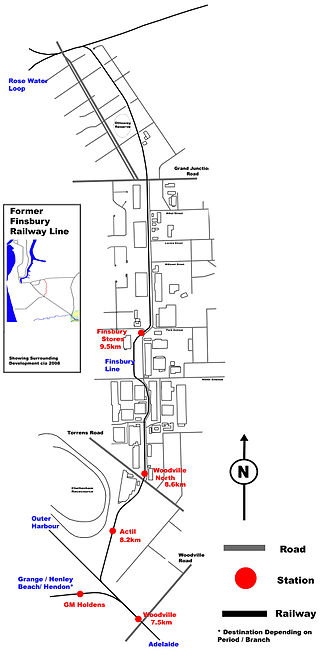
The Finsbury railway line is a defunct railway in north western Adelaide which was used mainly for industrial purposes in the 20th century. It ran through the suburbs of Woodville, Woodville North, Pennington and Ottoway, connecting the Outer Harbor line with the Dry Creek-Port Adelaide line. It serviced four stations; Actil, Woodville North, No. 18 Shed, and Finsbury Stores. It closed in 1979 and was dismantled in 1985.

Peterhead is a north-western suburb of Adelaide 15 km from the CBD, on the LeFevre Peninsula, in the state of South Australia, Australia and falls under the City of Port Adelaide Enfield. It is adjacent to Largs Bay and Birkenhead. The postcode for Peterhead is 5016. It is bounded to the north by Wills Street, to the south by Hargrave Street and in the west and east by the Outer Harbor railway line and the Port River respectively.

<span class="mw-page-title-main">Transport in Adelaide</span> Transportation network of Adelaide, Australia

The metropolitan area of Adelaide, South Australia is served by a wide variety of transport. Being centrally located on the Australian mainland, it forms a hub for east–west and north–south routes. The road network includes major expressways such as the Southern Expressway, the South Eastern Freeway, the Port River Expressway, the Northern Expressway and the South Road Superway. The city also has a public transport system managed by Adelaide Metro, consisting of a contracted bus system including the O-Bahn Busway, six metropolitan railway lines, and the Glenelg-Adelaide-Hindmarsh Tram. According to a study conducted by the Australian Bureau of Statistics, Adelaide has the highest passenger vehicle travel to work (84%) and the second lowest proportion of people walking to work (2.9%)–something that is being combated by the South Australian government in an effort to increase citizen ridership and use of public transport.

<span class="mw-page-title-main">Bowden, South Australia</span> Suburb of Adelaide, South Australia

Bowden is an inner northern suburb of Adelaide, South Australia. It is located in the City of Charles Sturt.

<span class="mw-page-title-main">Trams in Adelaide</span> Overview of trams in Adelaide, South Australia

Until 1958, trams formed a network spanning most of Adelaide, with a history dating back to 1878. Adelaide ran horse trams from 1878 to 1914 and electric trams from 1909, but has primarily relied on buses for public transport since the mid-20th century. Electric trams, and later trolleybuses, were Adelaide's main method of public transport throughout the life of the electric tram network. The tram network was progressively closed down through the 1950s with the last lines closing in 1958; the Glenelg tram line was the only line to survive these closures and has remained in operation ever since and has been progressively upgraded and extended since 2005.

Transport in South Australia is provided by a mix of road, rail, sea and air transport. The capital city of Adelaide is the centre to transport in the state. With its population of 1.4 million people, it has the majority of the state's 1.7 million inhabitants. Adelaide has the state's major airport and sea port.

References

  1. Outer Harbor & Grange timetable Archived 4 March 2016 at the Wayback Machine Adelaide Metro 23 February 2014
  2. Bowden cafe The Loose Caboose accused of heritage breaches after renovation Adelaide Advertiser 30 August 2013
  3. "And the worst rail stop in the west goes to …". The Advertiser. Adelaide. 8 September 2016. Retrieved 19 September 2017.
  4. "Torrens Rail Junction Project – DPTI – Department of Planning, Transport and Infrastructure South Australia". dpti.sa.gov.au. Archived from the original on 15 March 2018. Retrieved 8 January 2018.
  5. Dickers, Jessica (15 January 2018). "Trains tested on new underpass in SA". Infrastructure Magazine. Archived from the original on 24 June 2022. Retrieved 4 June 2023.
  6. SA, Service. "Adelaide Metro – Stop 12978". www.adelaidemetro.com.au. Archived from the original on 9 April 2017. Retrieved 8 January 2018.
  7. SA, Service. "Adelaide Metro – Stop 13006". www.adelaidemetro.com.au. Archived from the original on 9 April 2017. Retrieved 8 January 2018.

Commons-logo.svg Media related to Bowden railway station at Wikimedia Commons