Grange railway station

Last updated

Grange
Adelaide Metro 3000 red grange.jpg
3000 class railcar (mid-refurb) at Grange station
General information
LocationTerminus Street, Grange
Coordinates 34°54′01″S138°29′27″E / 34.9003°S 138.4908°E / -34.9003; 138.4908
Owned by Department for Infrastructure & Transport
Operated by Adelaide Metro
Line(s) Grange
Distance13 km from Adelaide
Platforms1
Tracks1
Bus routesH30
Connections Adelaide bus logo.svg Bus
Construction
Structure typeGround, side platform
ParkingYes
Bicycle facilitiesYes
AccessibleYes
Other information
Station code16523 (to City)
Website Adelaide Metro
History
Opened1882
Rebuilt1986
Services
Preceding station Adelaide Metro Following station
East Grange
towards Adelaide
Grange line Terminus

Grange railway station is the terminus station of the Grange line. [1] Situated in the western Adelaide suburb of Grange, it is 13 kilometres from Adelaide station.

Contents

History

Original station platform remnants, 2008. Former Grange Station.jpg
Original station platform remnants, 2008.

The original station, located 13.2 kilometres from Adelaide and on the western side of Military Road, was opened in September 1882 as the terminus of the Grange railway line. Initially operated by a private company, South Australian Railways took over the line in the 1890s, and extended it to Henley Beach station via the Henley Beach railway line. On 31 August 1957, however, the line was cut back to Grange.

On 9 March 1986, the current Grange station, on the eastern side of Military Road replaced the original station on the western side. The station was relocated to prevent traffic flow along Military Road from being interrupted by the arrival of trains. The ticket office and shelter of the original station were demolished shortly after, but the unused platform remains in place.

The station passenger shelter was replaced in 2017.

On 22 November 2022, a train derailed at the station by overshooting into the buffers. Nobody on the train was injured, and services resumed on the following day with trains terminating at the east end of the platform. [2]


Services by platform

PlatformLinesDestinationsNotes
1 Grange All stops services to Adelaide Terminus
Bus Transfers: Stop 30A (Military Road)
Route No.Destination & Route Details
136 City to Port Adelaide
via Henley Beach Road, Westfield West Lakes & Frederick Road [3]
137City to Westfield West Lakes
via Henley Beach Road & Turner Drive [4]
139City to Westfield West Lakes
via Henley Beach Road, Military Road & West Lakes Boulevard [5]

Related Research Articles

<span class="mw-page-title-main">Adelaide Metro</span> Public transport system in Adelaide, Australia

Adelaide Metro is the public transport system of Adelaide, the capital city of South Australia. It is an intermodal system offering an integrated network of bus, tram, and train services throughout the metropolitan area. The network has an annual patronage of 79.9 million, of which 51 million journeys are by bus, 15.6 million by train, and 9.4 million by tram. The system has evolved heavily over the past fifteen years, and patronage increased dramatically during the 2014–15 period, a 5.5 percent increase on the 2013 figures due to electrification of frequented lines.

<span class="mw-page-title-main">Tonsley railway station</span> Railway station in Adelaide, South Australia

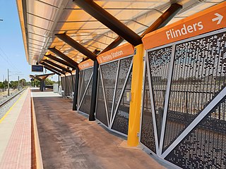
Tonsley railway station is located on the Flinders line in the south-western Adelaide suburb of Tonsley, 12.2 kilometres from Adelaide station. The original station was 13 kilometres from Adelaide and was the terminus of the line from its opening in 1966 until the station's closure in 2019; the station was then relocated to its current position and opened in 2020.

<span class="mw-page-title-main">Port Adelaide railway station</span> Railway station in Adelaide, South Australia

Port Adelaide station is a railway station located on the Outer Harbor line. Situated in the north-western Adelaide suburb of Alberton, it is 11.7 kilometres from Adelaide station.

<span class="mw-page-title-main">Woodville railway station, Adelaide</span> Railway station in Adelaide, South Australia

Woodville railway station is the junction station for the Grange and Outer Harbor lines with the lines diverging immediately north of the station. Situated in the western Adelaide suburb of Woodville, it is 7.5 kilometres from Adelaide station. It has auto pedestrian gates and lights. Platform 3 had a small kiosk, built around 2006, that sells refreshments and tickets, but has not been opened since 2009.

<span class="mw-page-title-main">Chatswood railway station</span> Railway station in Sydney

Chatswood is a railway station located in the Sydney suburb of Chatswood. It is served by Sydney Trains services; the T1 North Shore & Western Line and the T9 Northern Line, and the Sydney Metro's North West Line.

<span class="mw-page-title-main">Millswood railway station</span> Railway station in Adelaide, South Australia

Millswood railway station is located on the Belair line in Adelaide. Situated in the Adelaide suburb of Millswood, it is 5.9 kilometres (3.7 mi) from Adelaide station.

<span class="mw-page-title-main">Grange, South Australia</span> Suburb of Adelaide, South Australia

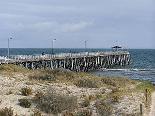
Grange is a coastal suburb of the City of Charles Sturt, in Adelaide, South Australia, located about 11 kilometres (6.8 mi) from the Adelaide city centre. The suburb is named after Captain Charles Sturt's cottage, built in 1840–41, which still stands and is now a museum. In addition to Grange Beach, the suburb has several parks and reserves, as well as the Grange Hotel, which was originally licensed in 1881.

<span class="mw-page-title-main">Outer Harbor line</span> Railway line in Adelaide, South Australia

The Outer Harbor line is a suburban branch line in Adelaide, South Australia. It runs from Adelaide station through the north western suburbs to Port Adelaide and Outer Harbor. It is 21.9 kilometres (13.6 mi) in length, and shares part of its run with the Grange line. It is operated by Adelaide Metro.

<span class="mw-page-title-main">Grange line</span> Railway line in South Australia

The Grange line is a suburban branch line in Adelaide, South Australia.

<span class="mw-page-title-main">Seaford line</span> Railway line in Adelaide, South Australia

The Seaford line is a suburban commuter line in Adelaide, South Australia.

<span class="mw-page-title-main">Peterhead railway station, Adelaide</span> Railway station in Adelaide, South Australia

Peterhead railway station is located on the Outer Harbor line. Situated in the north-western Adelaide suburb of Peterhead, it is 14.6 kilometres from Adelaide station.

<span class="mw-page-title-main">Glanville railway station</span> Railway station in Adelaide, South Australia

Glanville railway station is located on the Outer Harbor line. Situated in the north-western Adelaide suburb of Glanville, it is 13.8 kilometres from Adelaide station.

<span class="mw-page-title-main">Islington railway station</span> Railway station in Adelaide, South Australia

Islington railway station is located on the Gawler line. Situated in the inner northern Adelaide suburb of Prospect adjacent to Regency Road, it is 6 kilometres (3.7 mi) from the Adelaide station.

<span class="mw-page-title-main">Elizabeth railway station, Adelaide</span> Railway station in Adelaide, South Australia

Elizabeth railway station is located on the Gawler line. Situated on the border of the northern Adelaide suburbs of Elizabeth and Edinburgh, it is 25.8 kilometres (16.0 mi) from Adelaide station.

<span class="mw-page-title-main">Smithfield railway station</span> Railway station in Adelaide, South Australia

Smithfield railway station is a railway station and bus interchange in the northern Adelaide suburb of Smithfield. It is located on the Gawler line, 30.2 kilometres (18.8 mi) from Adelaide station.

<span class="mw-page-title-main">Gawler railway station</span> Railway station in Adelaide, South Australia

Gawler railway station is located on the Gawler line. Situated in the South Australian town of Gawler, it is 39.8 kilometres (24.7 mi) from Adelaide station.

<span class="mw-page-title-main">Henley Beach railway line</span>

The Henley Beach railway line is a defunct railway in western Adelaide, which operated from 1894 to 1957 as the final section of the Grange railway line.

<span class="mw-page-title-main">Henley Beach South, South Australia</span> Suburb of Adelaide, South Australia

Henley Beach South is a coastal suburb of Adelaide, South Australia. It is located in the City of Charles Sturt.

Henley Beach railway station was a railway station in the western Adelaide suburb of Henley Beach.

<span class="mw-page-title-main">Kirkcaldy railway station, Adelaide</span> Former railway station in South Australia, Australia

Kirkcaldy railway station is a former railway station in the western Adelaide suburb of Henley Beach.

References

  1. Outer Harbor & Grange timetable Archived 4 March 2016 at the Wayback Machine Adelaide Metro 23 February 2014
  2. Grange services resume after train overshoots rail line near Military Road (ABC News Australia)
  3. Route 136 Adelaide Metro
  4. Route 137 Adelaide Metro
  5. Route 139 Adelaide Metro