Goodwood railway station is a commuter railway station and the junction station for the Belair, Seaford and Flinders lines. The Belair line diverges south-east towards Millswood, while the Seaford and Flinders lines diverge south-west towards Clarence Park. The Glenelg tram line crosses over the railway lines at the south end of Goodwood station. The station services the Adelaide inner-southern suburb of Goodwood, and is 5.0 km from Adelaide station.

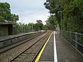
Unley Park railway station is located on the Belair line in suburban Adelaide. Situated seven kilometres from Adelaide station, it is on the boundary between Hawthorn and Westbourne Park, on the south side of Cross Road.

The Adelaide rail network is a metropolitan suburban rail system serving the city of Adelaide, South Australia, Australia. It consists of 89 railway stations across 7 lines, which served a patronage of 15.6 million people over the year 2018-19. Keolis Downer under contract from the Government of South Australia operates the Adelaide suburban rail system. The operations are set to be handed back to the hands of the public by January 2025.

The City of Mitcham is a local government area in the foothills of southern Adelaide, South Australia. Within its bounds is Flinders University, South Australia's third largest, and the notable, affluent suburb of Springfield which contains some of the city's most expensive properties.

Millswood railway station is located on the Belair line in Adelaide. Situated in the Adelaide suburb of Millswood, it is 5.9 kilometres (3.7 mi) from Adelaide station.

Bowden railway station is located on the Grange, Outer Harbor and Port Dock lines. Situated in the inner-city Adelaide suburb of Bowden, it is 2.7 kilometres from Adelaide station. The station was rebuilt and reopened in January 2018, with the original platforms closed and demolished; the southbound platform was closed and demolished in April 2017, a section of the northbound platform was retained due to the original station's 1856 brick and stone station building being located on that platform, which now houses The Loose Caboose Café.

Ethelton station is located on the Outer Harbor line. Situated in the north-western Adelaide suburb of Ethelton, it is 13.1 kilometres from Adelaide station. The station is currently closed for reconstruction.

The Outer Harbor line is a suburban commuter service in Adelaide, South Australia, that runs from Adelaide station through the north western suburbs to Port Adelaide and Outer Harbor.

The Gawler line, also known as the Gawler Central line, is a suburban commuter railway line in the city of Adelaide, South Australia. The Gawler Line is the most frequent and heavily patronised line in the Adelaide rail network. It is also the only line to have no other interchange with another line except Adelaide.

The Seaford line is a commuter railway line in the city of Adelaide, South Australia. It is the city's second longest metropolitan railway line at 35.9 kilometres (22.3 mi).

The Belair line is a suburban rail commuter route in the city of Adelaide, South Australia, that runs from the Adelaide station to Belair in the Adelaide Hills via the Adelaide-Wolseley line using diesel 3000/3100 class railcars. Prior to 1995, this part of Adelaide-Wolseley was a two-track broad gauge line. In 1995, Adelaide-Wolseley was converted to standard gauge meaning Adelaide to Belair is now effectively two separate single-track lines running in parallel: the Belair commuter line and the Adelaide-Wolseley standard gauge freight line.

The Flinders line is a suburban commuter line in Adelaide, South Australia, that branches off the Seaford line at Mitchell Park, and ends opposite Science Park, close to the Flinders University and the Flinders Medical Centre. The line is single track for most of its length, from Celtic Avenue, near Mitchell Park station, to its terminus.

Salisbury railway station is a railway station and bus interchange in the northern Adelaide suburb of Salisbury. It is on the Gawler line, 20.2 kilometres (12.6 mi) from Adelaide station. Adjoining it is a large park & ride carpark, making it one of the busiest stations on the Adelaide suburban rail system.
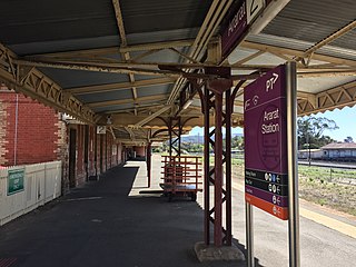
Ararat railway station is located on the Serviceton and Western standard gauge lines in Victoria, Australia. It serves the town of Ararat, and opened on 7 April 1875.
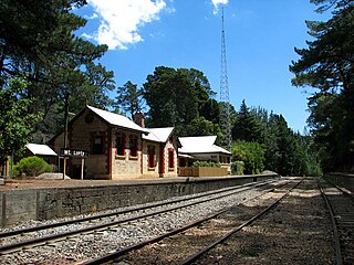
Mount Lofty Railway Station is located on the Adelaide-Wolseley line and served the Adelaide Hills suburb of Stirling. It is located 19+1⁄4 miles (31.0 km) from Adelaide station.
The Bridgewater railway line is a former passenger railway service on the Adelaide to Wolseley line in the Adelaide Hills. It was served by suburban services from Adelaide. On 26 July 1987, the service was curtailed to Belair and renamed Belair railway line. In 1995, the Adelaide-Wolseley line was converted to standard gauge as part of the One Nation infrastructure program, disconnecting the abandoned Bridgewater line stations from the broad gauge suburban railway system.

Madurta railway station was located on the Adelaide-Wolseley line serving the Adelaide Hills suburb of Aldgate to the east of the Cricklewood Road level crossing. It was located 34.1 km from Adelaide station.
Long Gully railway station was located on the Adelaide-Wolseley line in the Belair National Park, South Australia. It was located 21.1 km from Adelaide station.
The Adelaide–Wolseley railway line is a 313 kilometre line running from Adelaide to Wolseley on the Australian Rail Track Corporation network. It is the South Australian section of the Melbourne–Adelaide railway.