Konojedy | |
|---|---|
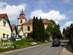 Church of Saint Wenceslaus | |
 Flag  Coat of arms | |
 Konojedy Location in the Czech Republic | |
| Coordinates: 49°56′55″N14°51′5″E / 49.94861°N 14.85139°E | |
| Country | |
| Region | Central Bohemian |
| District | Prague-East |
| First mentioned | 1352 |
| Area | |
• Total | 5.13 km2 (1.98 sq mi) |
| Elevation | 406 m (1,332 ft) |
| Population (2025-01-01) [1] | |
• Total | 290 |
| • Density | 57/km2 (150/sq mi) |
| Time zone | UTC+1 (CET) |
| • Summer (DST) | UTC+2 (CEST) |
| Postal code | 281 63 |
| Website | www |
Konojedy is a municipality and village in Prague-East District in the Central Bohemian Region of the Czech Republic. It has about 300 inhabitants.