Radonice | |
|---|---|
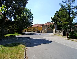 Centre of Radonice | |
 Flag  Coat of arms | |
 Radonice Location in the Czech Republic | |
| Coordinates: 50°8′35″N14°36′37″E / 50.14306°N 14.61028°E | |
| Country | |
| Region | Central Bohemian |
| District | Prague-East |
| First mentioned | 1397 |
| Area | |
• Total | 4.79 km2 (1.85 sq mi) |
| Elevation | 237 m (778 ft) |
| Population (2024-01-01) [1] | |
• Total | 1,122 |
| • Density | 230/km2 (610/sq mi) |
| Time zone | UTC+1 (CET) |
| • Summer (DST) | UTC+2 (CEST) |
| Postal code | 250 73 |
| Website | www |
Radonice is a municipality and village in Prague-East District in the Central Bohemian Region of the Czech Republic. It has about 1,100 inhabitants.