
Cape Coast is a city, fishing port, and the capital of Cape Coast Metropolitan District and Central Region of Ghana. It is one of the country's most historic cities, a World Heritage Site, home to the Cape Coast Castle, with the Gulf of Guinea situated to its south. According to the 2010 census, Cape Coast had a settlement population of 169,894 people. The language of the people of Cape Coast is Fante.

The Mfantsefo or Fante are an Akan people. The Fante people are mainly located in the Central and Western coastal regions of Ghana. Over the last half century, due to fishing expeditions, Fante communities have been established as far as Gambia, Liberia and even Angola. Major Fante cities in modern Ghana include Kasoa, Winneba, Agona Swedru, Tarkwa, Oguaa, Edina (Elmina), Mankessim, Sekondi, and Takoradi.
The Fante Confederacy refers either to the alliance of the Fante states in existence at least since the sixteenth century, or it can also refer to the modern Confederation formed in 1868. The Confederation is seen as one of the first and most prominent self-rule movements in Ghana and the entirety of Africa. Its mission was to shake off colonialism and establish a modern free democratic state.
The Akan people are a Kwa group living primarily in present-day Ghana and in parts of Ivory Coast and Togo in West Africa. The Akan speak dialects within the Central Tano branch of the Potou–Tano subfamily of the Niger–Congo family. Subgroups of the Akan people include: the Agona, Akuapem, Akwamu, Akyem, Anyi, Ashanti, Baoulé, Bono, Chakosi, Fante, Kwahu, Sefwi, Wassa, Ahanta and Nzema among others. The Akan subgroups all have cultural attributes in common; most notably the tracing of matrilineal descent in the inheritance of property, and for succession to high political office.
Abandze is a small town near the Atlantic Ocean coast of Ghana, lying north-east of Cape Coast in the Central Region of Ghana. In 2010, the town had a population of 3,632. It grew around the Dutch Fort Amsterdam, established in 1598. The fort was rebuilt as the British settlement in the region, renamed Fort York, in 1645. It was then recaptured by the Dutch in 1665 and reverted to its original name, mirroring the British takeover of New Amsterdam which renamed that settlement New York. Long since disused, the fort has since been partially restored and is sometimes known as Fort Kormantin.

The Central Region is one of the sixteen administrative regions of Ghana. It is bordered by Ashanti and Eastern regions to the north, Western region to the west, Greater Accra region to the east, and to the south by the Gulf of Guinea. The Central Region is renowned for its many elite high schools and an economy based on an abundance of industrial minerals and tourism. The Central region boasts of many tourist attractions such as castles, forts and beaches dotted along the region's coastline.
The Mankessim Kingdom (1252–1844) was a pre-colonial African state in modern-day Ghana. It is regarded as the heartland of the Fante people, and operated as capital of the Fante Confederacy in the 19th century. The town of Mankessim still exists, and is located in the Central Region of Ghana, about an hour and a half drive west of Accra. The Mankessim Kingdom's influence was quite vast; it extended to the whole of the Fante people, and at times the entire coast of modern-day Ghana.
Articles related to Ghana include:

Anomabu, also spelled Anomabo and formerly as Annamaboe, is a town on the coast of the Mfantsiman Municipal District of the Central Region of South Ghana. Anomabu has a settlement population of 14,389 people.

Mankessim is a town in the Central Region of Ghana, West Africa. It is approximately 75 km west of Accra, on the main road to Sekondi-Takoradi. It is the traditional headquarters of the Fante ethnic group of Ghana. Mankessim's history is linked to three famed warriors: Obrumankoma, Odapagyan and Oson, who helped the Fante people migrate from Techiman in the current Bono Region to Adoagyir in the Central Region. The town is located at an elevation of 75 meters above sea level and its population according to the 2010 Census was 38,313.

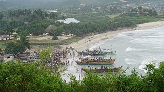
Biriwa is a town of Mfantsiman Municipal District in the Central Region of Ghana. According to the Ghana Statistical Service's 2010 Population and Housing Census, the population of Biriwa was 7,086. The main occupation is fishing, with a few people engaged in farming. It is a traditional setting which celebrates the Okyir festival every October. The current chief of the town, Nana Kwabonko V, resides in Saltpond.
Nana Amuah-Afenyi VI, known informally as King Peggy, is the reigning chief of the town of Tantum, in the Mfantsiman Municipal District, Ghana. Born in the Gold Coast and a naturalized citizen of the United States since 1997, she moved to the United States in the 1970s when she was in her early twenties to work as a secretary at the Embassy of Ghana in Washington, D.C., where she still works. Following the death of her uncle in 2008, she was selected as his successor through a series of traditional rituals. She is a devout Christian, and she lives in Silver Spring, Maryland.
Asebu was a former Fante chiefdom and town in the Abura/Asebu/Kwamankese District, Central Region, Ghana. In the history of the Gold Coast, Asebu is notable for being the first Fante chiefdom to sign a treaty with the Dutch Republic in 1612. The treaty allowed the Dutch to establish Fort Nassau at Mouri, now known as Moree.
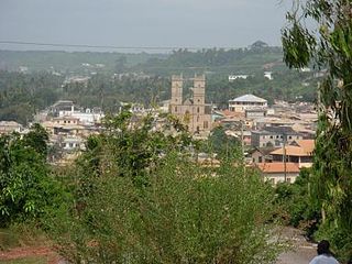
Mfantsiman Municipal Assembly is one of the twenty-two districts in Central Region, Ghana. Originally created as an ordinary district assembly in 1988 when it was known as Mfantsiman District, which was created from the former Mfantsiman District Council; until it was later elevated to municipal district assembly status on 29 February 2008 to become Mfantsiman Municipal District. However, on 28 June 2012, the eastern part of the district was split off to create Ekumfi District; thus, the remaining part has been retained as the Mfantsiman Municipal Assembly. The municipality is located in the southwest part of Central Region and has Saltpond as its capital town.

Fort Amsterdam is a former slave fort in Abandze, Central region, Ghana. It was built by the English between 1638 and 1645 as Fort Cormantin or Fort Courmantyne, and was captured by admiral Michiel de Ruyter of the Dutch West India Company in 1665, in retaliation for the capture of several Dutch forts by the English Admiral Holmes in 1664. It was subsequently made part of the Dutch Gold Coast, and remained part of it until the fort was traded with the British in 1868. The Fort is located at Abandze, on the north-east of Cape Coast in the Mfantseman District of the Central Region of Ghana. Because of its testimony to European economic and colonial influence in West Africa and its historical importance in the Atlantic slave trade, the fort was inscribed on the UNESCO World Heritage List in 1979 along with other forts and castles in Ghana.

Asafo are traditional warrior groups in Akan culture, based on lineal descent. The word derives from sa, meaning war, and fo, meaning people. The traditional role of the Asafo companies was defence of the state. As the result of contact with European colonial powers on the Gold Coast, the Fante, who inhabit the coastal region, developed an especially complex version of the concept in terms of its social and political organization based on martial principles, and with elaborate traditions of visual art, including flag banners with figurative scenes, and designs alluding to historical events or proverbs.
Fort Tantumquery is a military structure designed to facilitate the slave trade. The Royal African Company built it in the 1720s, at Otuam in the Mfantsiman Municipal District, Central Region, Ghana, in what was known at the time as the Gold Coast.
The Asafo flags are regimental flags of the Fante people, an ethnic group that mainly resides in Ghana's central coastal region. The flags are influenced by a combination of Akan proverbs, visual imagery, and European heraldic tradition.

Ghana–United Kingdom relations are the diplomatic, historical and trade relations between Ghana and the United Kingdom. Modern state Ghana-UK relations began when Ghana became independent from the UK in 1957.

The documented history of Elmina begins in 1482 with an agreement between the Portuguese navigator Diogo de Azambuja and the ruler of Elmina, called Caramansa by the Portuguese. In it, the Portuguese were allowed to build the first European fortress in sub-Saharan Africa. For the next 150 years until the conquest by the Dutch in 1637, Elmina was the capital of the Portuguese bases on the Gold Coast, then for about 250 years the capital of the Dutch Empire in West Africa. Since the capture of the lease for the two fortresses of Elmina by the Ashanti in 1701, the city was also important to the Ashanti Empire. Until the 19th century, Elmina was one of the most populous cities in the Gold Coast, surpassing Accra and Kumasi. The trade in gold, slaves and palm oil brought the city into direct contact with Europe, North America, Brazil and, through the recruitment of soldiers, also with Southeast Asia. It was not until the takeover and destruction of the city by the British in 1873 that Elmina lost its prominent position in the Gold Coast.
