Kosmos, South Africa

Last updated
Kosmos
South Africa-Hartbeespoot dam06.jpg
Kosmos seen from Hartbeespoort
South Africa North West location map.svg
Red pog.svg
Kosmos
South Africa adm location map.svg
Red pog.svg
Kosmos
Coordinates: 25°44′14″S27°51′13″E / 25.73722°S 27.85361°E / -25.73722; 27.85361
Country South Africa
Province North West
District Bojanala Platinum
Municipality Madibeng
Area
[1]
  Total0.91 km2 (0.35 sq mi)
Population
 (2011) [1]
  Total528
  Density580/km2 (1,500/sq mi)
Racial makeup (2011)
[1]
   Black African 30.1%
   Coloured 0.8%
   White 68.4%
  Other0.8%
First languages (2011)
[1]
   Afrikaans 43.5%
   Tswana 42.0%
   English 5.0%
   Zulu 1.9%
  Other7.5%
Time zone UTC+2 (SAST)
PO box
0261

Kosmos is a village in the North West Province of South Africa. It is situated on the western bank of the Hartbeespoort Dam. [2]

Contents

History

The first homes were built in the 1920s shortly after the Dam was constructed. It is thought that the name derives from the Kosmos which grows wild in great drifts in many parts of the Highveld, and in particular on the roads from the nearby major cities. More homes followed over the years, and the style moved steadily up market. Little development of commercial enterprises ever took place, although it is said that in earlier years the 'Sail Inn' on the waterfront was a favourite watering hole. Many Anglo–Boer War battles ranged around the area and the British built one of the blockhouses on the crest of the range above the village, in view of its strategic position.

In more recent years a restaurant immediately outside the original township, Stywe Lyne, (Tight Lines in Afrikaans) was a favourite destination for motorbike enthusiasts to gather on Sundays, and show off their bikes. This too has given way to the pressures of upmarket residential development.
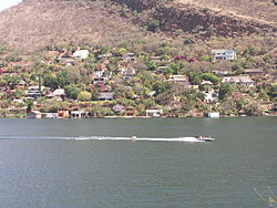
Modern day Kosmos

The village has only one access road, and perhaps as a result has developed a strong sense of community. The residents fund an illegal security gate which maintains the access gate to 'Kosmos Proper', a reference to that area lying within the boundaries of the original township. The gate is designed to stop the public from accessing Kosmos freely, something that is illegal in South Africa.[ citation needed ] On the higher slopes of the village there is a Community Centre and Library, on municipal land. Next to it is a Garden Chapel, where non-denominational religious services are conducted regularly by the residents. On the waterfront near the entrance the residents have developed the Kosmos Marina Club. There are Post Boxes but no Post Office, and no shops or other commercial enterprises. Recently a number of Bed and Breakfast establishments have started up.

Outside Kosmos Proper, on the short road leading to the village, several resort and residential estates have been developed and new ones are being built. One of these has a nine-hole golf course, which skirts the waters of the dam in a challenging manner.

In amongst these estates lies Orange Farm, an 'informal settlement' (which elsewhere might be termed a 'squatter camp' or 'shanty town'). In these shacks, with no proper supplies of electricity, water or sanitation, live hundreds of people who depend for their meagre livelihood on work as servants and jobs with building and construction companies. Efforts to relocate them to other locations further away with proper amenities have been unsuccessful.[ citation needed ]

Geology

At this point the Magaliesberg range is displaced about 1 kilometre south by faulting and erosion. [3] Kosmos lies on the south, steep side of the monocline, and at its north eastern end, where the Crocodile River passes through the Dam, the cliffs become too steep to allow buildings or a road.

Related Research Articles

<span class="mw-page-title-main">Snowy Mountains</span> Mountain range in Australia

The Snowy Mountains, known informally as "The Snowies", is an IBRA subregion in southern New South Wales, Australia, and is the tallest mountain range in mainland Australia, being part of the continent's Great Dividing Range cordillera system. It makes up the northeastern half of the Australian Alps and contains Australia's five tallest peaks, all of which are above 2,100 m (6,890 ft), including the tallest Mount Kosciuszko, which reaches to a height of 2,228 m (7,310 ft) above sea level. The offshore Tasmanian highlands makes up the only other major alpine region present in the whole of Australia.

<span class="mw-page-title-main">Keston</span> Human settlement in England

Keston is a village in Greater London, England, located within the London Borough of Bromley, Greater London. Prior to 1965 it was within the historic county of Kent. It is part suburban, part rural in nature and lies on the edge of Hayes Common, just beyond the London conurbation to the south of Bromley Common. It includes the small hamlet of Nash to the southwest. The northern, more suburban part of Keston is sometimes referred to as Keston Mark.

Laudium is an Indian township southwest of central Pretoria, in the City of Tshwane Metropolitan Municipality. Claudius is a residential suburb that is effectively an extension of Laudium.

Perry Beeches is an area of Great Barr, Birmingham, England, within the parliamentary constituency of Perry Barr.

<span class="mw-page-title-main">Brits, North West</span> Town in North West, South Africa

Brits is a town in the North West Province of South Africa. It is situated in a fertile citrus, vegetable and grain-producing area that is irrigated by the waters of the Hartbeespoort Dam. It is close to the City of Tshwane Metropolitan Municipality in Gauteng, which includes Pretoria, and it has the same dialling code as Pretoria. In addition to being a centre for agriculture, the city is home to several heavy industries. A factory of the Italian car manufacturer Alfa Romeo produced cars for the domestic market and export to Asia from 1974 to 1985. The city also plays an important role in the South African mining industry: 94% of South Africa's platinum comes from the Rustenburg and Brits districts, which together produce more platinum than any other single area in the world. In addition, there is a large vanadium mine in the district.

<span class="mw-page-title-main">Ballito</span> Place in KwaZulu-Natal, South Africa

Ballito is an affluent coastal town located in KwaZulu-Natal, South Africa. Ballito is about 40 kilometres (25 mi) north of Durban and 24 kilometres south of KwaDukuza. It forms part of the KwaDukuza Local Municipality, and iLembe District Municipality. Dolphins and Whales are common on this stretch of the North Coast shoreline, hence the nickname Dolphin Coast. The name of the town Ballito is named after the Italian word for "small ball".

The area referred to as Fourways is the fastest-developing commercial and residential hub in Sandton, north of Johannesburg, South Africa. The main access routes to Fourways are off the N1 at R511 Winnie Mandela Drive, or alternatively along R564 Witkoppen Road. It is located mostly in Region E of the City of Johannesburg Metropolitan Municipality. It is roughly as far as one can go in the Johannesburg Metropolitan area before it dissolves into rolling hills, game farms and the capital Pretoria, 55 kilometres to the northeast. Hartebeespoort Dam and the Magaliesberg Mountains lie half an hour to the north-west. It is bordered by Bryanston to the east and south and Randburg to the west.

<span class="mw-page-title-main">Suburbs of Johannesburg</span>

The suburbs of Johannesburg are officially demarcated areas within the City of Johannesburg Metropolitan Municipality, South Africa. As in other Commonwealth countries, the term suburb refers to a "neighbourhood", although in South Africa most "suburbs" have legally recognised borders and often separate postal codes. The municipal functions for the area, such as municipal policing and social services, are still managed by the city government.

<span class="mw-page-title-main">Hartbeespoort</span> Place in North West, South Africa

Hartbeespoort, informally known as "Harties", is a small resort town in the North West Province of South Africa, situated on slopes of the Magaliesberg mountain and the banks of the Hartbeespoort Dam. The name of the town means "gateway of the hartbees" in Afrikaans. Schoemansville, named after General Hendrik Schoeman, a Boer General in the Anglo-Boer War, who owned the farm that the Hartbeespoort Dam was built on, is the oldest neighbourhood of Hartbeespoort.

<span class="mw-page-title-main">Magaliesberg</span> Mountain range in South Africa

The Magaliesberg of northern South Africa, is a modest but well-defined mountain range composed mainly of quartzites. It rises at a point south of the Pilanesberg to form a curved prominence that intersects suburban Pretoria before it peters out some 50 km (31 mi) to the east, just south of Bronkhorstspruit. The highest point of the Magaliesberg is reached at Nooitgedacht, about 1,852 metres (6,076 ft) above sea level. A cableway reaching to the top of the mountain range is located at Hartbeespoort Dam, providing sweeping views of the Magaliesberg and surrounding area.

<span class="mw-page-title-main">Hartbeespoort Dam</span> Dam in North West Province

Hartbeespoort Dam is an arch type dam situated in the North West Province of South Africa. It lies in a valley to the south of the Magaliesberg mountain range and north of the Witwatersberg mountain range, about 35 kilometres north west of Johannesburg and 20 kilometres west of Pretoria. The name of the dam means "dam at the gorge of the hartebeest" in Afrikaans. This "poort" in the Magaliesberg was a popular spot for hunters, where they cornered and shot the hartebeest. The dam was originally designed for irrigation, which is currently its primary use, as well as for domestic and industrial use. The dam has suffered from a hypertrophic state since the early 1970s. Mismanagement of waste water treatment from urban zones within the Hartbeespoort Dam catchment area is largely to blame, having distorted the food web with over 280 tons of phosphate and nitrate deposits.

Gillitts is a town in the KwaZulu-Natal Province of South Africa.

<span class="mw-page-title-main">Avon Dam</span> Dam in Avon Dam, New South Wales

The Avon Dam is a heritage-listed dam in Avon, Wingecarribee Shire, New South Wales, Australia. It is one of four dams and weirs in the catchment of the Upper Nepean Scheme, providing water to the Macarthur and Illawarra regions, the Wollondilly Shire, and metropolitan Sydney. The arch dam across the Avon River was completed in 1927 under the supervision of Ernest Macartney de Burgh, the dam is currently managed by the Sydney Catchment Authority and is listed on the New South Wales State Heritage Register.

<span class="mw-page-title-main">Lake Swannanoa, New Jersey</span> Populated place in Morris County, New Jersey, US

Lake Swannanoa is a residential lake community located within Jefferson Township, in Morris County, in the U.S. state of New Jersey. It is within the scenic Skylands Region and approximately 38 miles (61 km) by road from New York City.

<span class="mw-page-title-main">Duporth</span> Human settlement in England

Duporth was situated on Porthpean Road, just outside St Austell in south Cornwall, England, UK. For over 50 years, it was a holiday resort, until its closure in 2006. The site has now been sold to private developers and now contains new houses in the traditional Cornish cottage style.

Mutasa District is one of seven districts in Manicaland Province of Zimbabwe. Mutasa District is located 30 km northeast of Mutare and stretches up to the Honde Valley, which is about 100 km northeast of Mutare along a tarred road that branches off the Nyanga road.

<span class="mw-page-title-main">Borrowdale, Harare</span> Neighborhood in Harare, Harare, Zimbabwe

Borrowdale is a residential suburb in the north of Harare, Zimbabwe, which ranks among the most affluent and prestigious residential areas in the country. It forms part of the Northeast suburbs of the city of Harare, with a population of 28,929 as of the Zimbabwe 2022 Census.

<span class="mw-page-title-main">Hennops River</span> River in South Africa

The Hennops River is one of the larger rivers that drains Gauteng, South Africa. It has its source near Kempton Park, east of Johannesburg and meets the Crocodile River shortly before Hartbeespoort Dam. It is one of Gauteng's most polluted rivers.

<span class="mw-page-title-main">Neepaulakating Creek</span> Tributary of Papakating Creek

Neepaulakating Creek is a 2.4-mile long (3.8 km) tributary of Papakating Creek in Wantage Township in Sussex County, New Jersey in the United States. It is one of three streams feeding the Papakating Creek, a major contributor to the Wallkill River. Although the stream was dammed in the 1950s to create Lake Neepaulin as the focal point of a private residential development, the stream did not receive a name until 2002. Residents chose a name that combined elements of the names "Neepaulin" and "Papakating", and submitted a proposal to the United States Board of Geographic Names. The name was approved in 2004.

References

  1. 1 2 3 4 "Sub Place Kosmos". Census 2011.
  2. Mather, Vernon. "Mr".
  3. Vincent Carruthers, The Magaliesberg, p.22, Southern Book Publishers (Pty) Ltd, 1990 ISBN   1-86812-246-8