
Mundkur is a village in Karkala Taluk, Udupi district, Karnataka, India. The Durga Parameshwari temple located here was built circa 9th century AD.

Belle is a village in the southern state of Karnataka, India. It is located in the Udupi taluk of Udupi district. The village is known for its historic Moodu-Belle Mahalingeshwara Temple dedicated to Shiva.
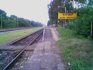
Surathkal is one of the major localities in the northern part of Mangalore city located on National highway 66 in the Dakshina Kannada district, Karnataka state, India on the shore of Arabian sea. It is a municipality merged with Mangalore City Corporation. It lies between Gurupura (Phalguni) and Pavanje (Nandini) rivers. It is the northern suburb & can be considered as the northernmost area of Mangalore City until Mukka. Surathkal is 1.5 km from Surathkal railway station, 8 km north of New Mangalore seaport, 8 km west of Mangalore Refinery & Petrochemicals Limited and 16 km west of Mangalore International Airport This region has developed educationally, industrially & commercially can be regarded as one of the crucial localities in Mangaluru & coastal Karnataka. The only NIT of Karnataka is situated here which is adjacent to the national highway NH 66. Mukka a popular name in Indian surfing is also situated close to Surathkal. Surathkal beach is well known for its cleanliness and well maintained like other beaches in Mangalore.
Bailhongal is a Taluk in Belagavi District of Karnataka state in southern India. Bailhongal Taluk is located towards the north-east part of Belagavi. The taluk headquarters is about 44 km from the district headquarters. The total geographical area of the taluk is 1122.40 km2. There are 126 revenue villages and 14 hamlets with a total population of 356,400 people, according to the 2001 census.
Brahmavar is a taluk in Udupi district located on NH 66, 13 kilometres (8.1 mi) north of the Udupi in Karnataka, India.
Basrur / Basroor is a village in Kundapur taluk in Udupi district of Karnataka. Historically Basrur was also called as Barcelor, Barcalor, Basnur, Bares, Abu-Sarur and Barsellor.
Parkala is a suburb of Udupi city located east of Manipal in Udupi district of Karnataka, India. It is administered in part by Udupi City Municipality and in part by the 80, Badagubettu Panchayat.
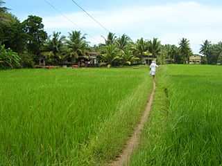
Pavanje is a village in Dakshina Kannada district of Karnataka state, India. It is sited on the north bank of the Nandini River, adjoining National Highway 66 between Udupi and Mangaluru. It lies just outside of Mangalore city and close to Mukka from where the city limits start. Pavanje bridge is the entrance to Mangalore city from north. Pavanje lies to south of Haleangadi. The Arabian sea is on west of this village. The village has lush green paddy fields and coconut plantations.

Anegudde is a village in the Kundapura taluk of Udupi district, India. The village is also known as Kumbashi. It lies en route from Udupi towards Kundapura on the NH 66.

Shri Gokarna Math or Partagali Math is the first Goud Saraswat Mathas of the Dvaita order, a system established by Jagadguru Madhvacharya in the 13th century AD. This matha also called Partagali Jivottama and is headquartered in Partagali, a small town in South Goa, on the banks of the river Kushavati.
Saligrama is a town on NH 66 in Brahmavara taluk of Udupi district in the Tulunadu region of the Indian state of Karnataka. It is located between Kundapura and Brahmavar. It is 21 km north of Udupi and 81 km from Mangalore.

Kapu (Kaup) is a town situated in the Udupi district of Karnataka, India. It lies between the twin cities of Udupi and Mangalore, next to the National Highway 66. The villages Manchakal and Shirva are located near Kapu. It is 13 km south of Udupi and 40 km north of Mangalore. It is known for its lighthouse, the three Mariamman shrines, and the Kapu fort built by Tippu Sultan. Kapu was declared a taluk of the Udupi district by the Government of Karnataka. Kapu was renamed Kaup by the British.
Peranankila or Pernankila is a village near Hiryadka of Udupi taluk and Udupi district. It is a mid-sized village located in the district of Udupi in the state of Karnataka in India. It had a population of about 2147 persons living in around 427 households according to 2001 census. There is an anganavadi kendra and a primary school in this village. There is a primary health center at the distance of nearly 0.5 km from Peranankila temple. There are two shops near Peranankila temple where people get items for daily use as well as items required for Pooja's.
Neelavara or Nilavara is a village in Brahmavar taluk of Udupi district in Karnataka, India. Neelavara is situated about 7 km from Brahmavar that lies on NH-17 and around 3 km from Kunjal that lies on the road from Brahmavar to Hebri. Neelavar lies roughly between the river Sita in the north and the village Kunjal to the south. Originally it was Neeravara, but later it became as Neelavara.
Nandalike is a village in Karkala taluk in the Udupi District in Karnataka, India. It is approximately 16 km east of Padubidri and about 15 km from Karkala town.
Uppunda is a large village in Byndoor Taluk with west coast of the village on the Arabian sea in South India. The nearest city with an airport is Mangalore which is about 119 kilo-meters away. The town is reachable by water and road from Mangalore. Nearest railway station Byndoor Mookambika Road(BYNR) railway station. It is located in the Byndoor taluk of Udupi district in Karnataka.
Kundapura Taluk is one of the richest taluk located in Udupi district in the Indian state of Karnataka.

The Mahabaleshwar Temple, Gokarna is a 4th-century CE Hindu temple located in Gokarna, Uttara Kannada district, Karnataka state, India which is built in the classical Dravidian architectural style. It is a site of religious pilgrimage. The temple faces the Gokarna beach on the Arabian Sea in which Hindu pilgrims cleanse before visiting the temple for worship. The temple is considered as holy as the Shiva temple at Varanasi or Kāśi (Kashi) in North India on the banks of the Ganges River. Hence, the Mahabaleshwar temple, Gokarna is known as the Dakshin Kasi. The temple deifies the Pranalinga also called Atmalinga or Shiva Linga In legend, it is said that the deity of the temple will bestow immense blessings to devotees, even to those who only glimpse it. Currently the administrative charge of the temple is with an Overseeing Committee under the Chairmanship of Justice BN Srikrishna, a Retired Justice of the Hon'ble Supreme Court of India.
Gundmi is a panchayat town in Udupi Taluk in Udupi district in the Indian state of Karnataka. Gundmi town is one of the oldest towns in India. The remains of its glorious history can be seen on the beaches and other parts of Gundmi.
Thombattu is a village in Kundapura Taluk in Karnataka, India. It is in the Udupi district. It is located 45 km towards North from District headquarters Udupi. 26 km from Kundapura. 410 km from State capital Bangalore. Kota, Udupi, Karkala, Sagar are the nearby cities.
