
Udupi is a city in the Indian state of Karnataka. Udupi is situated about 55 km (34 mi) north of the educational, commercial and industrial hub of Mangalore and about 422 km (262 mi) west of state capital Bangalore by road.

Kundapur, officially Kundapura, is a coastal town situated in the Udupi district of the state of Karnataka, India. This town was known as Coondapoor while it was part of the erstwhile South Canara district (1862–1947) of the Madras Presidency of British India. Present-day Kundapur is administered by the Kundapur Town Municipal Council and serves as the headquarters of the Kundapur Taluk of Udupi district.

Manipal is a suburb and university town within Udupi, in coastal Karnataka, India. Manipal is located five kilometres away from the centre of Udupi City, in Udupi District, Karnataka (state) in south western India. It is administered by the Udupi City Municipality. The suburb is located in coastal Karnataka, 62 km north of Mangalore and 8 km east of the Arabian Sea. From its location on a plateau, at an altitude of about 75 metres above sea level, it commands a panoramic view of the Arabian Sea to the west and the Western Ghats to the east.
Brahmavar is a taluk in Udupi district located on NH 66, 13 kilometres (8.1 mi) north of the Udupi in Karnataka, India.

Udupi district is an administrative subdivision in the Karnataka state of India, with the district headquarters in the city of Udupi. It is situated in the Canara old north Malabar coastal region. There are seven taluks, 233 villages and 21 towns in Udupi district. The three northern tehsils of Udupi, Kundapur and Karkala, were partitioned from Dakshina Kannada district to form Udupi district on 25 August 1997. Moodabidri was officially declared as new tehsil (taluk), separated from Karkala with effect from 11 January 2018.
Kallianpur is a hamlet of Tonse East village about six km from Udupi. It is a developed with all modern amenities like schools, college, hospital, good transport and communication facilities. The people of Kallianpur have survived many ages and still retain great positions with attachment to their culture. Some still date associate their surnames to their village Kallianpur.
Uppinakudru, located 6 km north of Kundapura Udupi District, is a small island village, once famous for trading of salt (uppu) and seafood. UppinaKudru (UK) is also having short name of UK. So this is called as UK of Kundapura. This is also known as 'The King of Kudrus'.
Kodavooru is a small town belonging to the temple city of Udupi in Karnataka, India. Home to Lord Shankaranarayana Temple and many other small sacred Hindu temples, it has a long history of its own.
Gangolli is a village in Kundapur Taluk of Udupi district in Karnataka state. It is situated at the estuary of the Panchagangavalli River. It is located on a peninsula on the west coast of Karnataka. It is bordered by the river to the east and by the Arabian Sea to the west.
Nitte is a village in Karkala Taluk, Udupi District, Karnataka, India. It is located on the way from Padubidri to Karkala, about 26 kilometres southeast of the district capital Udupi, and 7 kilometres southwest of the taluka capital Karkala. In the year 2011, the village is home to 12,354 inhabitants.
Karnataka's coastline called Karavali stretches 300 km between Mangalore in Dakshina Kannada district and Karwar in Uttara Kannada district. The coastline of Karnataka has been along the eastern shore of Arabian Sea. Karnataka has one major and ten minor ports in this coastal belt. Kali, Belekeri, Gangavali, Aghanashini Sharavathi, Sharabi, Kollur, Gangolli, Sitanadi, Gurpur and Netravati are the important rivers in this belt which empty into the Arabian sea. Sea erosion, migration of river mouths, siltation of ports and harbours are some of the problems common to this belt.
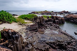
St. Mary's Islands, also known as Coconut Island and Thonsepar, are a set of four small islands in the Arabian Sea off the coast of Malpe in Udipi, Karnataka, India. They are known for their distinctive geological formation of columnar rhyolitic lava (pictured).
Kemmannu-Hoode-Bengre is a small village in the Udupi District of Karnataka State. It lies on the western coast of Karnataka, along the Suvarna River.

Karkala, also known as Karla in Tulu language, is a town and the headquarters of Karkala taluk in the Udupi district of Karnataka, India. Located about 60 km from Mangalore in the Tulu Nadu region of the state, it lies near the foothills of the Western Ghats. Karkala has a number of natural and historical landmarks, and is a major tourist and transit destination due to its strategic location along the way to Hebri, Sringeri, Kalasa, Horanadu, Udupi, Kollur, Subrahmanya and Dharmasthala.
Bijjur is a small village of gokarna in Uttar Kannada district are neighbouring villages in a valley in the south western section of Karnataka, India. Together they form a community of people from different castes and religions.

The Cathedral of Our Lady of Miracles, Indo-Portuguese; Catedral de Nossa Senhora dos Milagres, is a Roman Catholic Cathedral situated at Kallianpur in the Udupi district of Karnataka, India.

NITK Beach also known as Surathkal beach is on the Arabian Sea coast at Surathkal, 16 km (9.9 mi) north of the centre of Mangalore city, in the Dakshina Kannada district of Karnataka, India. It is a private beach that was later named after the nearby NITK.

The city of Mangalore is proclaimed as the gateway to Karnataka and lies nestled between the blue waters of the Arabian Sea and the green, towering hills of the Western Ghats. The 184 square km city is spread out over the backwaters of the two rivers, Netravati and Gurpura.
Delta Beach, also known as Kodi Bengre Beach, is located in a small village of Kodi Bengre in Udupi district, Karnataka. The beach is located at an estuary where the Swarna River meets the Arabian Sea.


