Kratzerville, Pennsylvania

Last updated
Kratzerville
Kratzerville PA Keystone Sign 2.jpg
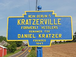
Keystone Marker for Kratzerville
USA Pennsylvania location map.svg
Red pog.svg
Kratzerville
Location within the U.S. state of Pennsylvania
Coordinates: 40°51′26″N76°53′38″W / 40.85722°N 76.89389°W / 40.85722; -76.89389
Country United States
State Pennsylvania
County Snyder
Area
[1]
  Total0.96 sq mi (2.49 km2)
  Land0.94 sq mi (2.43 km2)
  Water0.02 sq mi (0.06 km2)
Population
 (2020) [2]
  Total394
  Density419.60/sq mi (162.06/km2)
Time zone UTC-5 (Eastern (EST))
  Summer (DST) UTC-4 (EDT)
FIPS code 42-40432

Kratzerville is a census-designated place in Snyder County, Pennsylvania, United States. The population was 391 at the 2000 census.

Contents

Map of Snyder County, Pennsylvania with Municipal Labels showing Boroughs (red), Townships (white), and Census-designated places (blue). Map of Snyder County Pennsylvania With Municipal and Township Labels.png
Map of Snyder County, Pennsylvania with Municipal Labels showing Boroughs (red), Townships (white), and Census-designated places (blue).

Geography

Kratzerville is located at 40°51′26″N76°53′38″W / 40.85722°N 76.89389°W / 40.85722; -76.89389 (40.857229, -76.893989). [3]

According to the United States Census Bureau, Kratzerville has an area of 1.0 square mile (2.6 km2), all land.

Demographics

Historical population
CensusPop.Note
2020 394
U.S. Decennial Census [4]

As of the census [5] of 2000, there were 391 people, 160 households, and 122 families residing in Kratzerville. The population density was 398.6 inhabitants per square mile (153.9/km2). There were 167 housing units at an average density of 170.2 per square mile (65.7/km2). The racial makeup of Kratzerville was 98.98% White, 0.51% African American, 0.51% from other races. Hispanic or Latino of any race were 0.51% of the population.

There were 160 households, out of which 25.6% had children under the age of 18 living with them, 66.3% were married couples living together, 7.5% had a female householder with no husband present, and 23.8% were non-families. 20.6% of all households were made up of individuals, and 8.1% had someone living alone who was 65 years of age or older. The average household size was 2.44 and the average family size was 2.79.

The population of Kratzerville was spread out, with 18.4% under the age of 18, 9.7% from 18 to 24, 29.4% from 25 to 44, 29.7% from 45 to 64, and 12.8% who were 65 years of age or older. The median age was 42 years. For every 100 females, there were 92.6 males. For every 100 females age 18 and over, there were 91.0 males.

The median income for a household in Kratzerville was $42,292, and the median income for a family was $46,250. Males had a median income of $30,682 versus $22,321 for females. The per capita income for Kratzerville was $20,008. About 1.6% of families and 3.1% of the population were below the poverty line, including none of those under age 18 and 10.2% of those age 65 or over.

Government

Snyder County Government directory [ permanent dead link ]

Snyder County is governed by three elected county commissioners.

Notes

  1. "ArcGIS REST Services Directory". United States Census Bureau. Retrieved October 12, 2022.
  2. "Census Population API". United States Census Bureau. Retrieved Oct 12, 2022.
  3. "US Gazetteer files: 2010, 2000, and 1990". United States Census Bureau. 2011-02-12. Retrieved 2011-04-23.
  4. "Census of Population and Housing". Census.gov. Retrieved June 4, 2016.
  5. "U.S. Census website". United States Census Bureau . Retrieved 2008-01-31.

Related Research Articles

<span class="mw-page-title-main">Morgan County, Alabama</span> County in Alabama, United States

Morgan County is a county in the north central part of the U.S. state of Alabama. As of the 2020 census, its population was 123,421. The county seat is Decatur. The county was created by the Alabama Territorial legislature on February 6, 1818, from land acquired from the Cherokee people in the Treaty of Turkeytown, and was originally called Cotaco County. On June 14, 1821, it was renamed in honor of American Revolutionary War General Daniel Morgan of Virginia. It is a prohibition or dry county, although alcohol sales are allowed in the cities of Decatur, Hartselle, and Priceville. Morgan County is included in the Decatur, AL Metropolitan Statistical Area, which is also included in the Huntsville-Decatur-Albertville, AL Combined Statistical Area. It is a part of the North, Northwest, and North-Central regions of Alabama.

<span class="mw-page-title-main">Dozier, Alabama</span> Town in Alabama, United States

Dozier is a town in Crenshaw County, Alabama, United States. At the 2020 census, the population was 285. Dozier was incorporated in 1907.

<span class="mw-page-title-main">Timberlane, Illinois</span> Village in Illinois, United States

Timberlane is a village in Boone County, Illinois, United States. It is part of the Rockford, Illinois Metropolitan Statistical Area. The population was 906 at the 2020 census.

<span class="mw-page-title-main">Cissna Park, Illinois</span> Village in Illinois, United States

Cissna Park is a village in Pigeon Grove Township, Iroquois County, Illinois, United States. The population was 846 at the 2010 census.

Straight River Township is a township in Hubbard County, Minnesota, United States. The population was 662 at the 2000 census.

<span class="mw-page-title-main">Bluffton, Minnesota</span> City in Minnesota, United States

Bluffton is a city in Otter Tail County, Minnesota, United States, along the Leaf River. The population was 210 at the 2020 census.

Garfield Township is a township in Polk County, Minnesota, United States. It is part of the Grand Forks-ND-MN Metropolitan Statistical Area. The population was 391 at the 2000 census.

<span class="mw-page-title-main">Ephrata Township, Lancaster County, Pennsylvania</span> Township in Pennsylvania, United States

Ephrata Township is a township in northeastern Lancaster County, Pennsylvania, United States. The population was 10,391 at the 2020 census.

<span class="mw-page-title-main">East Berwick, Pennsylvania</span> Census-designated place in Pennsylvania, United States

East Berwick is a census-designated place (CDP) in Salem Township, Luzerne County, Pennsylvania, United States. The population was 2,007 at the 2010 census.

Altamont is a census-designated place (CDP) in Schuylkill County, Pennsylvania, United States. The population was 2,689 at the 2000 census.

<span class="mw-page-title-main">Brandonville, Pennsylvania</span> CDP in Pennsylvania, United States

Brandonville is a census-designated place (CDP) in East Union Township in Schuylkill County, Pennsylvania. The population was 180 at the 2020 census.

<span class="mw-page-title-main">Ringtown, Pennsylvania</span> Borough in Pennsylvania, United States

Ringtown is a borough in Schuylkill County, Pennsylvania, United States. It is approximately 5 miles north northwest of Shenandoah and 17 miles west southwest of Hazleton. Other nearby towns and boroughs include Zion Grove, Pattersonville and Nuremberg.

<span class="mw-page-title-main">Walker Township, Schuylkill County, Pennsylvania</span> Township in Pennsylvania, United States

Walker Township is a township in Schuylkill County, Pennsylvania, United States. The population was 994 at the 2020 census.

<span class="mw-page-title-main">Hummels Wharf, Pennsylvania</span> CDP in Pennsylvania, United States

Hummels Wharf is a census-designated place (CDP) in Snyder County, Pennsylvania, United States. The population was 641 at the 2000 census.

<span class="mw-page-title-main">Jackson Township, Snyder County, Pennsylvania</span> Township in Pennsylvania, United States

Jackson Township is a township in Snyder County, Pennsylvania, United States. The population was 1,584 at the 2020 census.

<span class="mw-page-title-main">Monroe Township, Snyder County, Pennsylvania</span> Township in Pennsylvania, United States

Monroe Township is a township in Snyder County, Pennsylvania, United States. The population was 4,145 at the 2020 census.

<span class="mw-page-title-main">Penns Creek, Pennsylvania</span> CDP in Pennsylvania, United States

Penns Creek is a census-designated place (CDP) in Snyder County, Pennsylvania.

<span class="mw-page-title-main">Washington Township, Snyder County, Pennsylvania</span> Township in Pennsylvania, United States

Washington Township is a township in Snyder County, Pennsylvania, United States. The population was 1,756 at the 2020 census.

<span class="mw-page-title-main">Bixby, Texas</span> CDP in Texas, United States

Bixby is a census-designated place (CDP) in Cameron County, Texas, United States. The population was 504 at the 2010 census. It is part of the Brownsville–Harlingen Metropolitan Statistical Area.

Langleyville is an unincorporated census-designated place in Christian County, Illinois, United States. As of the 2020 census, it had a population of 391.