Port Trevorton, Pennsylvania

Last updated

Port Trevorton
CDP
Port Trevorton, Pennsylvania 2.jpg
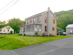
House in Port Trevorton
USA Pennsylvania location map.svg
Red pog.svg
Port Trevorton
Location within the U.S. state of Pennsylvania
Coordinates: 40°41′11″N76°53′13″W / 40.68639°N 76.88694°W / 40.68639; -76.88694
Country United States
State Pennsylvania
County Snyder
Area
[1]
  Total3.39 sq mi (8.78 km2)
  Land3.38 sq mi (8.76 km2)
  Water0.01 sq mi (0.02 km2)
Population
 (2020) [2]
  Total734
  Density217.10/sq mi (83.83/km2)
Time zone UTC-5 (Eastern (EST))
  Summer (DST) UTC-4 (EDT)
ZIP code
17864
Area code(s) 570 and 272
FIPS code 42-62312

Port Trevorton is a census-designated place (CDP) in Snyder County, Pennsylvania, United States. The population was 451 at the 2000 census.

Contents

Map of Snyder County, Pennsylvania with Municipal Labels showing Boroughs (red), Townships (white), and Census-designated places (blue). Map of Snyder County Pennsylvania With Municipal and Township Labels.png
Map of Snyder County, Pennsylvania with Municipal Labels showing Boroughs (red), Townships (white), and Census-designated places (blue).

Geography

Port Trevorton is located at 40°41′11″N76°53′13″W / 40.68639°N 76.88694°W / 40.68639; -76.88694 (40.686397, -76.886956). [3]

According to the United States Census Bureau, the CDP has a total area of 2.8 square miles (7.3 km2), all land.

Demographics

Historical population
CensusPop.Note
2020 734
U.S. Decennial Census [4]

As of the census [5] of 2000, there were 451 people, 166 households, and 118 families residing in the CDP. The population density was 163.9 inhabitants per square mile (63.3/km2). There were 183 housing units at an average density of 66.5 per square mile (25.7/km2). The racial makeup of the CDP was 99.33% White, 0.22% African American, 0.22% Native American and 0.22% Asian. Hispanic or Latino of any race were 0.22% of the population.

There were 166 households, out of which 32.5% had children under the age of 18 living with them, 59.6% were married couples living together, 7.8% had a female householder with no husband present, and 28.9% were non-families. 25.9% of all households were made up of individuals, and 12.0% had someone living alone who was 65 years of age or older. The average household size was 2.72 and the average family size was 3.32.

In the CDP, the population was spread out, with 30.2% under the age of 18, 9.5% from 18 to 24, 27.1% from 25 to 44, 21.7% from 45 to 64, and 11.5% who were 65 years of age or older. The median age was 33 years. For every 100 females, there were 101.3 males. For every 100 females age 18 and over, there were 92.1 males.

The median income for a household in the CDP was $38,158, and the median income for a family was $40,625. Males had a median income of $31,458 versus $19,167 for females. The per capita income for the CDP was $12,363. About 6.5% of families and 9.3% of the population were below the poverty line, including 14.4% of those under age 18 and 14.3% of those age 65 or over.

History

The name of the town comes from its days as a coal port on the Pennsylvania Canal. Coal from the mines of the Zerbe Valley, near Trevorton was shipped to the town via the Trevorton and Susquehanna Railroad, which was completed in 1855, crossing the Susquehanna River on a long bridge from Herndon to Port Trevorton. A canal basin was built for coal loading from the railcars. However, a new route was built to the coal mines via Shamokin, and the bridge was removed in 1870. As the fortunes of the canal declined, so too did those of the town. [6]

See also

Related Research Articles

Rheems is an unincorporated community and census-designated place (CDP) in Lancaster County, Pennsylvania, United States, between the boroughs of Elizabethtown and Mount Joy. The population was 1,598 during the 2010 census.

Horseheads North is a census-designated place (CDP) in Chemung County, New York, United States. It is part of the Elmira Metropolitan Statistical Area. As of the 2010 census, the population of the CDP was 2,843.

<span class="mw-page-title-main">Seven Fields, Pennsylvania</span> Place in Pennsylvania, United States

Seven Fields is a borough in Butler County, Pennsylvania, United States. The population was 2,887 at the 2010 census, an increase from the figure of 1,986 tabulated in 2000.

<span class="mw-page-title-main">North Philipsburg, Pennsylvania</span> Census designated place in Pennsylvania, United States

North Philipsburg is an unincorporated community and census-designated place (CDP) in Centre County, Pennsylvania, United States. It is part of the State College, Pennsylvania Metropolitan Statistical Area. The population was 660 at the 2010 census.

<span class="mw-page-title-main">Almedia, Pennsylvania</span> Census-designated place in Pennsylvania, United States

Almedia is a census-designated place (CDP) in Columbia County, Pennsylvania, United States. It is part of Northeastern Pennsylvania. The population was 1,078 at the 2010 census. It is part of the Bloomsburg-Berwick micropolitan area.

Foundryville is a census-designated place (CDP) in Columbia County, Pennsylvania, United States. It is part of Northeastern Pennsylvania. The population was 256 at the 2010 census. It is part of the Bloomsburg-Berwick micropolitan area.

<span class="mw-page-title-main">Lime Ridge, Pennsylvania</span> Census-designated place in Pennsylvania, United States

Lime Ridge is a census-designated place (CDP) in Columbia County, Pennsylvania, United States. It is part of Northeastern Pennsylvania. The population was 890 at the 2010 census. It is part of the Bloomsburg-Berwick micropolitan area.

<span class="mw-page-title-main">Millersburg, Pennsylvania</span> Borough in Pennsylvania, United States

Millersburg is a borough in Dauphin County, Pennsylvania, United States. The population was 2,541 at the 2020 census. It is part of the Harrisburg–Carlisle Metropolitan Statistical Area.

<span class="mw-page-title-main">Salunga-Landisville, Pennsylvania</span> CDP in Pennsylvania, United States

Salunga-Landisville consists of two census-designated places (CDPs) in Lancaster County, Pennsylvania, United States with a zip code of 17538. As of the 2010 United States Census the population of Salunga CDP was 2,695 people and the population of Landisville CDP was 1,893 people for a combined total of 4,588, a decrease of about 3.8% from the 2000 United States Census which recorded 4,771 in the Salunga-Landisville CDP. The name "Salunga" comes from the nearby Chiquesalunga Creek, which in turn is derived from the Lenape "Chiquesalunga", meaning "place of the crayfish". Landisville is named for John Landis, the first postmaster there.

Lebanon South is an unincorporated area and census-designated place (CDP) in Lebanon County, Pennsylvania, United States. The population was 2,270 at the 2010 census.

<span class="mw-page-title-main">East Berwick, Pennsylvania</span> Census-designated place in Pennsylvania, United States

East Berwick is a census-designated place (CDP) in Salem Township, Luzerne County, Pennsylvania, United States. The population was 2,007 at the 2010 census.

<span class="mw-page-title-main">Glen Lyon, Pennsylvania</span> Census-designated place in Pennsylvania, United States

Glen Lyon is a census-designated place (CDP) in Newport Township, Luzerne County, Pennsylvania, United States. The population was 1,873 at the 2010 census.

<span class="mw-page-title-main">Edgewood, Northumberland County, Pennsylvania</span> CDP in Pennsylvania, United States

Edgewood is a census-designated place (CDP) located in Coal Township, in Northumberland County, Pennsylvania, United States. The population was 2,619 at the 2000 census.

<span class="mw-page-title-main">Tuscarora, Pennsylvania</span> CDP in Pennsylvania, United States

Tuscarora is a census-designated place (CDP) that is located in Schuylkill County, Pennsylvania, United States. The population was 980 at the time of the 2010 census.

<span class="mw-page-title-main">Chapman Township, Snyder County, Pennsylvania</span> Township in Pennsylvania, United States

Chapman Township is a township in Snyder County, Pennsylvania, United States. The population was 1,563 at the 2020 census.

<span class="mw-page-title-main">Union Township, Snyder County, Pennsylvania</span> Township in Pennsylvania, United States

Union Township is a township in Snyder County, Pennsylvania, United States. The population was 1,491 at the 2020 census.

<span class="mw-page-title-main">Susquehanna Trails, Pennsylvania</span> CDP in Pennsylvania, United States

Susquehanna Trails is a census-designated place (CDP) in York County, Pennsylvania, United States. The population was 2,264 at the 2010 census.

<span class="mw-page-title-main">York Haven, Pennsylvania</span> Borough in Pennsylvania, United States

York Haven is a borough in York County, Pennsylvania, United States. The population was 691 at the 2020 census. The borough is the home of the Brunner Island coal-fired electrical generation plant, located on the Susquehanna River on Wago Road and operated by PPL Corporation.

<span class="mw-page-title-main">Hingham (CDP), Massachusetts</span> Census-designated place in Massachusetts, United States

Hingham is a census-designated place (CDP) in the town of Hingham in Plymouth County, Massachusetts, United States. The population was 5,650 at the 2010 census.

Duncott is a census-designated place (CDP) in Schuylkill County, Pennsylvania, United States, near Minersville in the Coal Region. The population was 76 at the 2000 census. It is located in Cass Township.

References

  1. "ArcGIS REST Services Directory". United States Census Bureau. Retrieved October 16, 2022.
  2. "Census Population API". United States Census Bureau. Retrieved October 16, 2022.
  3. "US Gazetteer files: 2010, 2000, and 1990". United States Census Bureau. February 12, 2011. Retrieved April 23, 2011.
  4. "Census of Population and Housing". Census.gov. Retrieved June 4, 2016.
  5. "U.S. Census website". United States Census Bureau . Retrieved January 31, 2008.
  6. Nickelsen, Richard, "Susquehanna River: A Pathway Northward For Migrating Water Fowl" Archived 2007-09-29 at the Wayback Machine . Bucknell University Web Site. Susquehanna River Initiative. 2007