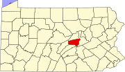
Adams Township, Snyder County, Pennsylvania

Last updated

Adams Township,
Snyder County,
Pennsylvania
Adams Township Sunny Farm.jpg
An Adams Township farm
Map of Snyder County, Pennsylvania Highlighting Adams Township.PNG
Map of Snyder County, Pennsylvania highlighting Adams Township
Map of Pennsylvania highlighting Snyder County.svg
Map of Snyder County, Pennsylvania
Country United States
State Pennsylvania
County Snyder
Settled1754
Incorporated1874
Area
[1]
  Total20.59 sq mi (53.33 km2)
  Land20.18 sq mi (52.26 km2)
  Water0.42 sq mi (1.08 km2)
Population
 (2020) [2]
  Total895 Decrease2.svg
  Estimate 
(2022) [2]
895
  Density45.30/sq mi (17.49/km2)
Time zone UTC-5 (Eastern (EST))
  Summer (DST) UTC-4 (EDT)
Area code 570
FIPS code 42-109-00316
Map of Snyder County, Pennsylvania with Municipal Labels showing Boroughs (red), Townships (white), and Census-designated places (blue). Map of Snyder County Pennsylvania With Municipal and Township Labels.png
Map of Snyder County, Pennsylvania with Municipal Labels showing Boroughs (red), Townships (white), and Census-designated places (blue).

Adams Township in Snyder County, Pennsylvania, United States, is a township which had a population of 907 at the 2010 census. [3] Per the US Census Bureau, by 2020 the population had reduced to 895 people. [2]

Contents

Geography

According to the United States Census Bureau, the township has a total area of 20.9 square miles (54 km2), of which 20.5 square miles (53 km2) is land and 0.3 square miles (0.78 km2) (1.67%) is water. [4]

Adams Township is bordered by Union County to the north, Center Township to the east, Beaver Township to the south and Spring Township to the west. [5]

The census-designated place of Troxelville is in Adams Township.

Demographics

Historical population
CensusPop.Note
2010 907
2020 895−1.3%
2022 (est.)895 [2] 0.0%
U.S. Decennial Census [6]

As of the census [7] of 2000, there were 852 people, [8] 320 households, and 253 families residing in the township. The population density was 41.5 inhabitants per square mile (16.0/km2). There were 376 housing units at an average density of 18.3/sq mi (7.1/km2). The racial makeup of the township was 99.53% White, 0.23% African American, 0.23% from other races. Hispanic or Latino of any race were 0.47% of the population. [9]

There were 320 households, out of which 37.5% had children under the age of 18 living with them, 66.3% were married couples living together, 7.8% had a female householder with no spouse present, and 20.9% were non-families. 17.2% of all households were made up of individuals, and 7.5% had someone living alone who was 65 years of age or older. The average household size was 2.66 and the average family size was 2.97. [10]

In the Township, the population was spread out, with 26.3% under the age of 18, 7.4% from 18 to 24, 30.2% from 25 to 44, 23.9% from 45 to 64, and 12.2% who were 65 years of age or older. The median age was 37 years. For every 100 females, there were 101.4 males. For every 100 females age 18 and over, there were 100.6 males.

The median income for a household in the township was $29,940, and the median income for a family was $37,292. Males had a median income of $26,167 versus $21,635 for females. The per capita income for the township was $16,217. About 4.8% of families and 8.0% of the population were below the poverty line, including 7.4% of those under age 18 and 9.9% of those age 65 or over. [10]

Recreation

Walker Lake is a 239-acre (97 ha) man-made lake owned by the Commonwealth of Pennsylvania. [11] It is managed by the Pennsylvania Fish and Boat Commission for public fishing and boating. The Commission stocks the Lake with northern pike and walleye fingerling. The lake was created by damming the North Branch of Middle Creek. [12] Middle Creek flows across Adams Township and has many tributaries. Moyers Mill Run flows from northern Adams Township and empties into Walker Lake.

Related Research Articles

<span class="mw-page-title-main">Hamiltonban Township, Pennsylvania</span> Township in Pennsylvania, United States

Hamiltonban Township is a township in Adams County, Pennsylvania, United States. The population was 2,300 at the 2020 census.

<span class="mw-page-title-main">Mount Joy Township, Adams County, Pennsylvania</span> Township in Pennsylvania, United States

Mount Joy Township is a township in Adams County, Pennsylvania, United States. The population was 3,670 at the 2010 census.

<span class="mw-page-title-main">Columbia Township, Bradford County, Pennsylvania</span> Township in Pennsylvania, United States

Columbia Township is a township in Bradford County, Pennsylvania, United States. It is part of Northeastern Pennsylvania. The population was 1,196 at the 2010 census. Children residing in the township are assigned to attend the Troy Area School District.

<span class="mw-page-title-main">Stevens Township, Pennsylvania</span> Township in Pennsylvania, United States

Stevens Township is a township in Bradford County, Pennsylvania, United States. The population was 437 at the 2010 census.
<span class="mw-page-title-main">Clearfield Township, Butler County, Pennsylvania</span> Township in Pennsylvania, United States

Clearfield Township is a township in Butler County, Pennsylvania, United States. The population was 2,430 at the 2020 census.

<span class="mw-page-title-main">Woodward Township, Clearfield County, Pennsylvania</span> Township in Pennsylvania, United States

Woodward Township is a township in Clearfield County, Pennsylvania, United States. The population was 4,108 at the 2020 census.

<span class="mw-page-title-main">Washington Township, Erie County, Pennsylvania</span> Township in Pennsylvania, United States

Washington Township is a township in Erie County, Pennsylvania, United States. The population was 4,396 at the 2020 census, down from 4,432 at the 2010 census. The township surrounds the borough of Edinboro.

<span class="mw-page-title-main">Rockefeller Township, Pennsylvania</span> Township in Pennsylvania, United States

Rockefeller Township is a township in Northumberland County, Pennsylvania, United States. The population at the 2010 Census was 2,273, an increase over the figure of 2,221 tabulated in 2000.

<span class="mw-page-title-main">Carroll Township, Perry County, Pennsylvania</span> Township in Pennsylvania, United States

Carroll Township is a second class township in Perry County, Pennsylvania, United States. The population was 5,230 at the 2020 census. It is one of twenty-two (22) townships in Perry County and one of 1,456 townships in the Commonwealth of Pennsylvania.

<span class="mw-page-title-main">Hector Township, Potter County, Pennsylvania</span> Township in Pennsylvania, United States

Hector Township is a township in Potter County, Pennsylvania, United States. The population was 343 at the 2020 census.

<span class="mw-page-title-main">Keating Township, Potter County, Pennsylvania</span> Township in Pennsylvania, United States

Keating Township is a township in Potter County, Pennsylvania, United States. The population was 289 at the 2020 census.

<span class="mw-page-title-main">Sharon Township, Pennsylvania</span> Township in Pennsylvania, United States

Sharon Township is a township in Potter County, Pennsylvania, United States. The population was 789 at the 2020 census.

<span class="mw-page-title-main">Delano Township, Pennsylvania</span> Township in Pennsylvania, United States

Delano Township is a township in Schuylkill County, Pennsylvania, United States. Formed in 1882 from part of Rush Township, it is named for Warren Delano Jr., maternal grandfather of Franklin Delano Roosevelt, 32nd President of the United States, 1933–1945.

<span class="mw-page-title-main">East Norwegian Township, Pennsylvania</span> Township in Pennsylvania, United States

East Norwegian Township is a township in Schuylkill County, Pennsylvania, United States. The population was 864 at the 2020 census.

<span class="mw-page-title-main">Black Township, Pennsylvania</span> Township in Pennsylvania, United States

Black Township is a township in Somerset County, Pennsylvania, United States. The population was 899 at the 2020 census. It is part of the Johnstown, Pennsylvania, Metropolitan Statistical Area. The township was named for Jeremiah Sullivan Black, a native of Somerset County who became Chief Justice of the Supreme Court of Pennsylvania, U.S. Attorney General, and U.S Secretary of State.

<span class="mw-page-title-main">Elk Lick Township, Pennsylvania</span> Township in Pennsylvania, United States

Elk Lick Township is a township in Somerset County, Pennsylvania, United States. The population was 2,264 at the 2020 census. Mount Davis, the highest point in Pennsylvania, is located within the township.

<span class="mw-page-title-main">Mead Township, Pennsylvania</span> Township in Pennsylvania, United States

Mead Township is a township in Warren County, Pennsylvania, United States. The population was 1,298 at the 2020 census, down from 1,386 at the 2010 census and 1,555 at the 2000 census.

<span class="mw-page-title-main">Pleasant Township, Pennsylvania</span> Township in Pennsylvania, United States

Pleasant Township is a township in Warren County, Pennsylvania, United States. The population was 2,250 at the 2020 census, down from 2,444 at the 2010 census.

<span class="mw-page-title-main">Heidelberg Township, York County, Pennsylvania</span> Township in Pennsylvania, United States

Heidelberg Township is a township in York County, Pennsylvania, United States. The township was erected in 1750 and encompassed the land grant known as Digges' Choice, a warrant granted to John Digges in 1727 by the colonial-era Province of Maryland, prior to the time the Mason-Dixon line fixed the final boundary between Maryland and Pennsylvania. The population of Heidelberg Township was 3,027 at the 2020 census.

<span class="mw-page-title-main">North Codorus Township, Pennsylvania</span> Township in Pennsylvania, United States

North Codorus Township is a township in York County, Pennsylvania, United States. The population was 9,149 at the 2020 census.

References

  1. "2016 U.S. Gazetteer Files". United States Census Bureau. Retrieved August 14, 2017.
  2. 1 2 3 4 "City and Town Population Totals: 2020-2022". Census.gov. US Census Bureau . Retrieved January 31, 2024.
  3. US Census Bureau, American Fact Finder, Adams Township, Snyder County, Pennsylvania - 2010 Demographic Profile, 2013
  4. City-Data.com (2014). "Adams Township, Snyder County, Pennsylvania (PA)".
  5. Snyder County GIS Office (2014). "Adams Township, Snyder County Road Map" (PDF).
  6. "Census of Population and Housing". Census.gov. Retrieved June 4, 2016.
  7. "U.S. Census website". United States Census Bureau . Retrieved January 31, 2008.
  8. Snyder County Commissioners (2014). "2014 Local Government Officials Directory" (PDF).
  9. US Census Bureau, 2010 Census Poverty Data by Local Education Agency, 2011
  10. 1 2 US Census Bureau (2014). "U.S. Census website".
  11. Pennsylvania Fish and Boat Commission (2014). "Pennsylvania Lakes". Archived from the original on February 27, 2014. Retrieved June 21, 2014.
  12. Pennsylvania Department of Transportation (2014). "Map Adams Township, Snyder County, Pennsylvania" (PDF).[ permanent dead link ]

40°50′00″N77°09′59″W / 40.83333°N 77.16639°W / 40.83333; -77.16639