Freeburg, Pennsylvania

Last updated
Freeburg, Pennsylvania
Freeburg, Pennsylvania 1.JPG
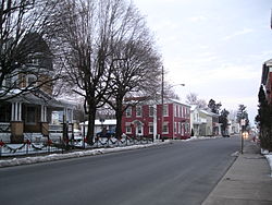
Market Street (PA 35) in 2013
Snyder County Pennsylvania Incorporated and Unincorporated areas Freeburg Highlighted.svg
Location of Freeburg in Snyder County, Pennsylvania.
USA Pennsylvania location map.svg
Red pog.svg
Freeburg
Location within the U.S. state of Pennsylvania
Usa edcp location map.svg
Red pog.svg
Freeburg
Freeburg (the United States)
Coordinates: 40°45′50″N76°56′15″W / 40.76389°N 76.93750°W / 40.76389; -76.93750 Coordinates: 40°45′50″N76°56′15″W / 40.76389°N 76.93750°W / 40.76389; -76.93750
Country United States
State Pennsylvania
County Snyder
Settled1796
Incorporated (borough)1920
Area
[1]
  Total0.32 sq mi (0.83 km2)
  Land0.32 sq mi (0.83 km2)
  Water0.00 sq mi (0.00 km2)
Elevation
[2] (center of borough)
525 ft (160 m)
Highest elevation
[2] (western and northeastern borough boundary)
580 ft (180 m)
Lowest elevation
[2] (Susquehecka Creek)
482 ft (147 m)
Population
 (2020) [3]
  Total557
  Density1,746.08/sq mi (674.44/km2)
Time zone Eastern (EST)
  Summer (DST)EDT
FIPS code 42-27696

Freeburg is a borough in Snyder County, Pennsylvania, United States. The population was 557 at the 2020 census. [4]

Contents

Geography

According to the United States Census Bureau, the borough has a total area of 0.3 square miles (0.78 km2), all land.

Freeburg is surrounded by Washington Township.

Demographics

Historical population
CensusPop.
1880 523
1890 5403.3%
1930 391
1940 46719.4%
1950 5068.4%
1960 57513.6%
1970 63610.6%
1980 6431.1%
1990 640−0.5%
2000 584−8.7%
2010 575−1.5%
2020 557−3.1%
2021 (est.)554 [4] −0.5%
Sources: [5] [6] [7] [3]

As of the census [6] of 2000, there were 584 people, 242 households, and 171 families residing in the borough. The population density was 2,066.6 people per square mile (805.3/km2). There were 248 housing units at an average density of 877.6 per square mile (342.0/km2). The racial makeup of the borough was 99.32% White, 0.34% African American, 0.17% Asian, and 0.17% from two or more races.

There were 242 households, out of which 28.5% had children under the age of 18 living with them, 56.2% were married couples living together, 7.4% had a female householder with no husband present, and 29.3% were non-families. 26.9% of all households were made up of individuals, and 15.3% had someone living alone who was 65 years of age or older. The average household size was 2.41 and the average family size was 2.86.

In the borough the population was spread out, with 23.6% under the age of 18, 7.0% from 18 to 24, 26.7% from 25 to 44, 23.6% from 45 to 64, and 19.0% who were 65 years of age or older. The median age was 40 years. For every 100 females there were 98.0 males. For every 100 females age 18 and over, there were 89.8 males.

The median income for a household in the borough was $30,729, and the median income for a family was $40,357. Males had a median income of $29,821 versus $20,625 for females. The per capita income for the borough was $15,893. About 4.5% of families and 9.1% of the population were below the poverty line, including 12.1% of those under age 18 and 8.7% of those age 65 or over.

History

Andrew Straub circa 1796 laid out the village of Freeburg, Snyder County, which at first was known as 'Straubstown', but later changed to Freeburg. He donated a plot of land to form a church and graveyard. The graveyard is called the Evergreen Cemetery.

Notes

  1. "ArcGIS REST Services Directory". United States Census Bureau. Retrieved October 12, 2022.
  2. 1 2 3 "Salem Topo Map, Snyder County PA (Freeburg Area)". TopoZone. Locality, LLC. Retrieved 26 November 2019.
  3. 1 2 "Census Population API". United States Census Bureau. Retrieved Oct 12, 2022.
  4. 1 2 Bureau, US Census. "City and Town Population Totals: 2020-2021". Census.gov. US Census Bureau. Retrieved 14 July 2022.
  5. "Census of Population and Housing". U.S. Census Bureau. Retrieved 11 December 2013.
  6. 1 2 "U.S. Census website". United States Census Bureau . Retrieved 2008-01-31.
  7. "Incorporated Places and Minor Civil Divisions Datasets: Subcounty Resident Population Estimates: April 1, 2010 to July 1, 2012". Population Estimates. U.S. Census Bureau. Archived from the original on 11 June 2013. Retrieved 11 December 2013.

Related Research Articles

<span class="mw-page-title-main">Freeburg, Missouri</span> Village in Missouri, United States

Freeburg is a village in Osage County, Missouri, United States. The population was 409 at the 2020 census. It is part of the Jefferson City, Missouri Metropolitan Statistical Area.

<span class="mw-page-title-main">Platea, Pennsylvania</span> Borough in Pennsylvania, United States

Platea is a borough in Erie County, Pennsylvania, United States. The population was 443 at the 2020 census.

<span class="mw-page-title-main">Wattsburg, Pennsylvania</span> Borough in Pennsylvania, United States

Wattsburg is a borough in Erie County, Pennsylvania, United States. The population was 352 at the 2020 census. It is part of the Erie Metropolitan Statistical Area.

<span class="mw-page-title-main">Thompsontown, Pennsylvania</span> Borough in Pennsylvania, United States

Thompsontown is a borough in Juniata County, Pennsylvania, United States. The population was 629 at the 2020 census.

<span class="mw-page-title-main">Enon Valley, Pennsylvania</span> Borough in Pennsylvania, United States

Enon Valley is a borough in Lawrence County, Pennsylvania, United States. The population was 297 at the 2020 census. It is part of the New Castle micropolitan area.

<span class="mw-page-title-main">South New Castle, Pennsylvania</span> Borough in Pennsylvania, United States

South New Castle is a borough in Lawrence County, Pennsylvania, United States. The population was 649 at the 2020 census. South New Castle is primarily a residential neighborhood which lies south of the city of New Castle, and is part of the New Castle micropolitan area.

<span class="mw-page-title-main">Clark, Pennsylvania</span> Borough in Pennsylvania, United States

Clark is a borough in Mercer County, Pennsylvania, United States. The population was 576 at the 2020 census. It is part of the Youngstown-Warren metropolitan area.

<span class="mw-page-title-main">New Lebanon, Pennsylvania</span> Borough in Pennsylvania, United States

New Lebanon is a borough in Mercer County, Pennsylvania, United States. The population was 186 at the 2020 census. It is part of the Youngstown-Warren metropolitan area.

<span class="mw-page-title-main">Sandy Lake, Pennsylvania</span> Borough in Pennsylvania, United States

Sandy Lake is a borough in Mercer County, Pennsylvania, United States. It was established in 1849. The population was 649 at the 2020 census. Sandy Lake is part of the Youngstown-Warren metropolitan area.

<span class="mw-page-title-main">Sheakleyville, Pennsylvania</span> Borough in Pennsylvania, United States

Sheakleyville is a borough in Mercer County, Pennsylvania, United States. The population was 142 at the 2010 census, a figure which increased to 150 tabulated residents in 2020. It is part of the Youngstown-Warren metropolitan area.

<span class="mw-page-title-main">Stoneboro, Pennsylvania</span> Borough in Pennsylvania, United States

Stoneboro is a borough in Mercer County, Pennsylvania, United States. The population was 946 at the 2020 census. It is part of the Youngstown-Warren metropolitan area.

<span class="mw-page-title-main">Herndon, Pennsylvania</span> Borough in Pennsylvania, United States

Herndon, formerly Trevorton Junction, is a borough along the Susquehanna River in Northumberland County, Pennsylvania, United States. Herndon was first founded by Robert A. Parrish in 1840. The town was later named for Naval commander William Lewis Herndon, who died in 1857 while trying to rescue passengers from his sinking ship. The population was 324 at the 2010 census.

<span class="mw-page-title-main">Marion Heights, Pennsylvania</span> Borough in Pennsylvania, United States

Marion Heights is a borough in Northumberland County, Pennsylvania, United States. The population was 611 at the 2010 census.

<span class="mw-page-title-main">Riverside, Pennsylvania</span> Borough in Pennsylvania, United States

Riverside is a borough in Northumberland County, Pennsylvania, United States. The population was 1,932 at the 2010 census. The current mayor is John LaMotte.

<span class="mw-page-title-main">Snydertown, Northumberland County, Pennsylvania</span> Borough in Pennsylvania, United States

Snydertown is a borough in Northumberland County, Pennsylvania, United States. As of the 2010 census, the borough population was 339.

<span class="mw-page-title-main">New Bloomfield, Pennsylvania</span> Borough in Pennsylvania, United States

New Bloomfield is a borough and county seat of Perry County, Pennsylvania, United States. It is part of the Harrisburg–Carlisle metropolitan statistical area. The population was 1,244 at the 2020 census.

<span class="mw-page-title-main">Beavertown, Snyder County, Pennsylvania</span> Borough in Pennsylvania, United States

Beavertown is a borough in Snyder County, located in Central Pennsylvania's Susquehanna River Valley, United States. The population was 1,005 at the 2020 census.

<span class="mw-page-title-main">Middleburg, Pennsylvania</span> Borough in Pennsylvania, United States

Middleburg is a borough in Snyder County, located in Central Pennsylvania's Susquehanna River Valley. The population was 1,325 at the 2020 census. It is the county seat of Snyder County. Middleburg is part of the Selinsgrove, PA Micropolitan Statistical Area, and is also part of the larger Bloomsburg-Berwick-Sunbury, PA Combined Statistical Area.

<span class="mw-page-title-main">Washington Township, Snyder County, Pennsylvania</span> Township in Pennsylvania, United States

Washington Township is a township in Snyder County, Pennsylvania, United States. The population was 1,756 at the 2020 census.

<span class="mw-page-title-main">New Berlin, Pennsylvania</span> Borough in Pennsylvania, United States

New Berlin is a borough in Union County, Pennsylvania, United States. The population was 791 at the 2020 census.