
The Shiawassee National Wildlife Refuge is a 9,870.35 acres (39.9439 km2) National Wildlife Refuge in Saginaw County managed by the United States Fish and Wildlife Service. It is located in the central portion of the lower peninsula of the U.S. state of Michigan, approximately 25 miles (40 km) south of the Saginaw Bay in Lake Huron and five miles (8 km) south of the city of Saginaw in the county's Spaulding and James townships. It was established in 1953 to provide habitat for migratory waterfowl.
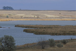
Huron Wetland Management District is located in the U.S. state of South Dakota and includes 17,518 acres (70.89 km2). The refuge borders the Missouri River on the east and is managed by the U.S. Fish and Wildlife Service. Huron WMD covers eight counties in east-central South Dakota. The topography of this area ranges from flat, gently rolling drift prairie to the Missouri Coteau hills in the western end of the district. The district lies in the midst of the Prairie Pothole Region.
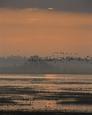
Sand Lake National Wildlife Refuge is located in the northeastern part of the U.S. state of South Dakota and is administered by the U.S. Fish and Wildlife Service. Created in 1935, it is a wetland of international importance and a Globally Important Bird Area. Over 260 bird species are found in the refuge, including many migratory bird species and the world's largest breeding colony of Franklin's gulls.

Chase Lake National Wildlife Refuge is located in the U.S. state of North Dakota around Chase Lake. The majority of the land area of the refuge has been designated as wilderness and is known as the Chase Lake Wilderness. The refuge is one of the oldest in the U.S., having been set aside in 1908. The refuge is home to one of the largest nesting colonies of white pelicans in the U.S.

Arrowwood Wetland Management District is located in the U.S. state of North Dakota. Arrowwood WMD is a part of the Arrowwood National Wildlife Refuge Complex, and is managed by the U.S. Fish and Wildlife Service. The district consists of 28 Waterfowl Production Areas, 314 Wetland easements, one easement refuge known as Johnson Lake National Wildlife Refuge and another four easements through the Farmers Home Administration, altogether totalling 28,922 acres (117 km2).
Hobart Lake National Wildlife Refuge is a 2,077-acre (8.41 km2) Easement Refuge located in Barnes County, North Dakota five miles (8 km) west of Valley City.
The Half-Way Lake National Wildlife Refuge is located in the U.S. state of North Dakota and consists of 160 acres (0.65 km2). The refuge is a "limited-interest" refuge, which is privately owned easement refuge, managed by the U.S. Fish and Wildlife Service. The refuge is closed to the public and was established to protect habitat for migratory bird species and other animal life. Chase Lake Wetland Management District oversees the refuge, which in turn is a part of the Arrowwood National Wildlife Refuge Complex.
Audubon Wetland Management District is located in the U.S. state of North Dakota and consists of 123 Waterfowl Production Areas (WPAs), 8 National Wildlife Refuges (NWRs), and numerous wetland and grassland easements and over 100 separate wetland areas set aside to preserve habitat for bird, plant and mammal species. These lands contain valuable wetland and grassland habitat for waterfowl and other migratory birds, and many other species of wildlife. Scattered throughout west central and southwestern North Dakota in McLean, Ward, and Sheridan Counties, the district is managed by the U.S. Fish and Wildlife Service and from Audubon National Wildlife Refuge. Hundreds of lakes and marshlands in this region provide critical habitat for migratory and nesting bird species.

Lake Ilo National Wildlife Refuge (NWR) is located in the U.S. state of North Dakota and is managed from Audubon National Wildlife Refuge by the U.S. Fish and Wildlife Service. The refuge consists of Lake Ilo, surrounding wetlands and some upland range, providing habitat for hundreds of species of birds, and numerous fish and mammal species. An average of over 16 inches (40 cm) of precipitation falls annually, supporting a prairie ecosystem.

Glacial Ridge National Wildlife Refuge was created on October 12, 2004, the 545th National Wildlife Refuge in the United States. Its creation was the result of cooperation between at least 30 agencies or governmental entities. The creation of the refuge was spearheaded by The Nature Conservancy, and the initial endowment of 2,300 acres (9.3 km2) of land was donated by the Conservancy. In light of its planned final size of 37,756 acres (153 km2), it is described by the US Fish and Wildlife Service as "the largest tallgrass prairie and wetland restoration project in U.S. history."
Handy Brake National Wildlife Refuge is located just north of Bastrop, Louisiana in Morehouse Parish, north central Louisiana. The refuge was established in 1988 with the southeast's first fee title transfer of a Farmer's Home Administration tract to the U.S. Fish and Wildlife Service. A free lease of 38 acres (150,000 m2) from International Paper increased the refuge to the current 501 acres (2.03 km2).
Lacassine National Wildlife Refuge is located in Cameron and Evangeline Parishes in southwestern Louisiana, was established in 1937 by Executive Order No. 7780 as "a refuge and breeding ground for migratory birds and other wildlife." The refuge is nearly 35,000 acres (140 km2) in size, including 653 acres (2.64 km2) leased from the Cameron Parish School Board. The Evangeline Parish unit is called Duralde Prairie and is currently being developed. It is located south of the city of Eunice.
The San Luis National Wildlife Refuge Complex is located in the northern San Joaquin Valley, within Merced County and Stanislaus County of California. The complex, with four federal National Wildlife Refuges, is managed by the U.S Fish & Wildlife Service.

Straddling the headwaters of the Minnesota River in west-central Minnesota, Big Stone National Wildlife Refuge is within the heart of the tallgrass prairie's historic range. Today, less than one-percent of tallgrass prairie remains.

Hagerman National Wildlife Refuge (HNWR), a haven for migratory birds and other wildlife, lies in northwestern Grayson County, Texas, on the Big Mineral Arm of Lake Texoma, on the Red River between Oklahoma and Texas. This National Wildlife Refuge is made up of water, marsh, and upland habitat. Visitors can hike, observe wildlife, hunt, and fish throughout the year.
Bone Hill National Wildlife Refuge is a National Wildlife Refuge in North Dakota. It is managed under Kulm Wetland Management District.
Dakota Lake National Wildlife Refuge is a National Wildlife Refuge in North Dakota. It is managed under Kulm Wetland Management District.
Maple River National Wildlife Refuge is a National Wildlife Refuge in North Dakota. It is managed under Kulm Wetland Management District.
Devils Lake Wetland Management District is located in the heart of the Prairie Pothole Region of the United States. The District was established in 1962 to purchase and protect wetland habitat for migratory waterfowl and other wildlife in northeastern North Dakota. One of the primary objectives of Devils Lake Wetland Management District is to provide wetland and grassland habitat for waterfowl in the spring and summer for nesting and feeding. The other primary objective is to provide migration habitat for waterfowl in the spring and fall.

Chase Lake is a 2,053 acres (8.31 km2), shallow lake in Stutsman County, North Dakota. It is the focal point of several protected areas administered by the U.S. Fish and Wildlife Service and U.S. Geographical Survey. It is known as one of the largest nesting areas for the American white pelican.

