Shimajiri District is a district located in Okinawa Prefecture, Japan. Modern translation of Shimajiri means "Butt of the island" which may refer to its southerly position on the island of Okinawa. Compare this to Kunigami District, Okinawa.

Kumejima is a town located in Shimajiri District, Okinawa Prefecture, Japan. The town consists of the islands of Kume, Ōjima, Ōhajima, Torishima, and Iōtorishima. Among the islands, only Kumejima and Ōjima are populated. Kumejima is located approximately 100 kilometres (62 mi) west of Naha. The town can be accessed by the New Kumejima Ferry, Japan Transocean Air, or Ryukyu Air Commuter. Kumejima Airport serves the island. As of 2016, the town had an estimated population of 7,647 and a population density of 120 inhabitants per square kilometre (310/sq mi). The total area is 63.50 km2 (24.52 sq mi).

Okayama Airport is an airport in Okayama Prefecture, Japan. It is also known as Okayama Momotaro Airport.

Fukue Airport, is a third class airport located 1.7 NM southwest of Gotō, Nagasaki Prefecture, off the western coast of Kyūshū, Japan. The airport also serves the city of Fukue. It is also known as Gotō-Fukue Airport and, since 2014, also styled Gotō Tsubaki Airport (五島つばき空港).. Currently the terminal building's exterior displays both names. Tsubaki means camellia, and is a notable reference on Fukue Island which is famed for producing camellia oil and is home to two ancient camellia trees each over 300 years old that have been declared 'national monuments'

Nanki–Shirahama Airport is a third class airport located in the town of Shirahama, Wakayama, Japan. It serves the southern part of the Kii Peninsula with three daily Japan Airlines round-trips to Tokyo International Airport, utilizing Boeing 737-800 aircraft. The travel time is 65 minutes to Haneda and 75 minutes in reverse direction.

Yonaguni Airport, is a third-class airport located in Yonaguni, Yaeyama District, Okinawa Prefecture, Japan.
Izumo Airport is an airport in the Hikawa area of Izumo, Shimane Prefecture, Japan, about 20–30 minutes by car from central Izumo or Matsue city centre. This airport is also known as Izumo En-Musubi Airport (出雲縁結び空港); meaning Izumo Airport of Romantic Fate.

Matsumoto Airport (松本空港), also known as Shinshu-Matsumoto Airport, is an airport located 5 NM southwest of central Matsumoto, Nagano Prefecture, Japan.

Miyazaki Airport, also known as Miyazaki Bougainvillea Airport, is an international airport located 3.2 km (2.0 mi) south southeast of Miyazaki, a city in the Miyazaki Prefecture of Japan.
Oita Airport is an airport in Kunisaki, Ōita, Japan, 16 NM northeast of Ōita.

Iki Airport is a small airport in the city of Iki on Iki Island in Nagasaki Prefecture, Japan.

Iejima Airport is located on the island of Iejima in Ie, Kunigami District, Okinawa Prefecture, Japan. The runways were part of the Ie Shima Airfield complex built during World War II. In 2015, the government was planning for Iejima Airport to have a new terminal and to expand the runway to 2,000 meters in length to enable the airport to accommodate jet service.
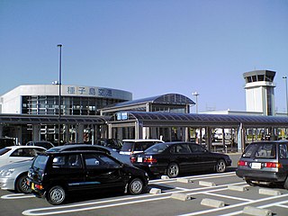
New Tanegashima Airport, also known as Tanegashima Airport, is located in Nakatane, on Tanegashima, one of the Ōsumi Islands in southern Kagoshima Prefecture, Japan.

Sado Airport is a public aerodrome located in Sado, Niigata Prefecture, Japan.

Ojika Airport is a public aerodrome, located about 3.0 km (1.9 mi) southeast of the town office in Ojika, Nagasaki Prefecture, Japan.

Fukui Airport is a public aerodrome located 5.0 NM north of Fukui Station in the city of Sakai, Fukui Prefecture, Japan. It is also referred to as Harue Airport from its location in former Harue town.

Kumejima Prefectural Natural Park is a Prefectural Natural Park in the islands of Kumejima, Okinawa Prefecture, Japan. It was established in 1983 and includes a designated marine zone of 57 km².
Kumejima Museum, formerly the Kumejima Centre for Nature and Culture (久米島自然文化センター), opened in 2000 in Kumejima, Okinawa Prefecture, Japan. It displays exhibits relating to the natural and cultural history of Kume Island.
Tatami-ishi, literally "tatami stones", is a geological feature in Kumejima, Okinawa, Japan. Located on the south coast of the island of Ōjima, to the immediate southeast of Kume Island, it lies within Kumejima Prefectural Natural Park. Exposed at low tide, the feature comprises some one thousand pentagonal and hexagonal rocks, each 1 to 1.5 metres in diameter, stretching fifty metres from north to south over a length of two hundred and fifty metres. It was formed during the Miocene period by the columnar jointing of andesitic lava as it cooled and contracted. The name is derived from the resemblance to a room of close-fitted tatami mats, while the feature is sometimes also likened to a turtle's carapace. In 1967 Tatami-ishi was designated a Natural Monument by the Government of the Ryukyu Islands. With the reversion of Okinawa to Japan in 1972, it was redesignated a Prefectural Cultural Property. In 2014 an area of 29.3 ha was designated a national Natural Monument.