
Ernakulam, IPA: [erɐɳɐːguɭɐm]; ISO: Eṟaṇākuḷaṁ, in Malayalam: എറണാകുളം), is one of the 14 districts in the Indian state of Kerala, that takes its name from the eponymous city division in Kochi. It is situated in the central part of the state, spans an area of about 3,000 square kilometres (1,200 sq mi), and is home to over 9% of Kerala's population. Its headquarters are located at Kakkanad. The district includes Kochi, also known as the commercial capital of Kerala, which is famous for its ancient Churches, Hindu temples, synagogues and mosques. The district includes the largest metropolitan region of the state: Greater Cochin. Ernakulam is the district that yields the most revenue and the largest number of industries in the state. Ernakulam is the third most populous district in Kerala, after Malappuram and Thiruvananthapuram. The district also hosts the highest number of international and domestic tourists in Kerala state.
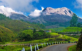
Munnar is a town and hill station in the Idukki district of the southwestern Indian state of Kerala. Munnar is situated at around 1,600 metres (5,200 ft) above mean sea level, in the Western Ghats mountain range. Munnar is also called the "Kashmir of South India" and is a popular honeymoon destination.

Idukki (ഇടുക്കി), IPA: [iɖukːi], is one of the 14 districts in the Indian state of Kerala. Idukki district lies amid the Cardamom Hills of Western Ghats in Kerala. Idukki district contains two municipal towns - Kattappana and Thodupuzha. The district currently includes five taluks in it.
Aluva is a region in Kochi City in Kerala, India. It is also a part of the Kochi metropolitan area and is situated around 15 km (9.3 mi) from the city center on the banks of Periyar River. A major transportation hub, with easy access to all major forms of transportation, Aluva acts as a corridor which links the highland districts to the rest of Kerala. Cochin International Airport at Nedumbassery is 11.7 km from Aluva. Aluva is accessible through rail, air, metro along with major highways and roadlines. Aluva KSRTC bus station is an important transport hub in Kerala and one of the busiest stations in central part of the state.
North Paravur. formerly known as Paravur or Parur, is a municipality and suburb in Ernakulam district in the Indian state of Kerala. It is a northern suburb of the city of Kochi and is situated around 20 km from the city centre. It is also the first place in India to use electronic voting machine during the by-elections in 1982.

Kumily, also spelt as Kumaly is a revenue village and Gram Panchayat in the Idukki district of Kerala. It is a town in Cardamom Hills near Thekkady and Periyar Tiger Reserve. Kumily is a gateway town into Kerala from Tamil Nadu.
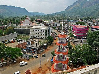
Kattappana is a municipal town in the Sahyadri of Kerala state, India. It is the main urban centre in the high ranges of Idukki district, situated about 2,788.71–2,952.76 feet (850.00–900.00 m) from sea level. It is the second city to become a municipality in Idukki District. It is a major commercial town and flourished with the boost in production of agriculture and spices.
Manathoor is a small village in Kottayam district, aside Pala - Thodupuzha Highway, 12 km from Palai town and 15 km from Thodupuzha town.

Bison valley is a village in Udumbanchola Taluk in the Idukki district of the southwestern Indian state of Kerala. Bison valley is situated at around 914 metres (3000 ft) above mean sea level, in the Western Ghats range of mountains.
Rajakkad is a town in the Idukki district in the Indian state of Kerala situated in the Western Ghats.
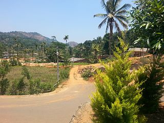
Thankamany is a village at Idukki district, in Kerala state, India. There is a small town associated with this village. In regional language thankamany is a name of a lady. It is a belief that an older jungle king Thopran gave dowry as land for his three daughters Thankamony, Kamashi, and Neeli. The place got for Thankamony is now known as Thankamony, other nearby places are also known as Kamashi and Neelivayal. Thankamany town is located in a valley of three small hills Thamprankunnu, Kattadikavala and Kurishupara respectively. One of the interesting thing is that, even though Kamashi is a different place, the panchayath of thankamany is called Kamashy panchayath and the office is situated in the middle of thankamany town.Sometimes in official documents thankamony is also written as thankamony. Nearest towns are Kattappana and Nedumkandam.
Adimali is a town in the Idukki district of Kerala, India. National Highway 185 is a highway in India running from Adimali to Kumily through Kattappana and ends in Adoor in Kerala. Adimaly is located on the National Highway 49, now NH 85, known as Kochi-Dhanushkodi National Highway, earlier known as the Kochi Madhura Highway (India) connecting Kochi and Madurai, India. From Adimaly, it is only 27 kilometers to Munnar, which is a famous hill station. The waterfalls Cheeyappara, Adimali waterfalls and Valara are located nearby. Pepper and cocoa cultivation is the main agricultural activity of this place. The Ponmudi Dam was constructed in 1963 across the Panniar river, nearly 15 km southeast of Adimali, on the way to Rajakkad.Thopramkudy is the nearest town. Adimali is known for its proximity to Munnar and natural environment. Adimali has almost all the basic facilities like roads, super markets, markets, educational institutions and hospitals.

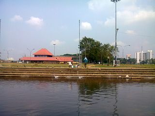
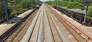
Aluva railway station is a railway station in Aluva, in the city of Kochi in the state of Kerala. It is an NSG 3 grade station under Thiruvananthapuram railway division. It lies in the Shoranur–Cochin Harbour section of Thiruvananthapuram railway division.

Muttom is a rural area in Idukki district in the Indian state of Kerala. This place is 66 km away from Cochin. Geographically this place is part of Midland or Idanad region of Kerala.
Pottankad is a village located in the Idukki district of Kerala, India. It is about 3020 ft. above sea level. A tourist destination, Munnar, is within 20 km of Pottankad. Most of the people depend on agriculture, and the main cultivations are cardamom and black pepper.
Tripunithura railway station is a railway terminal located at Tripunithura, Kochi, in the Indian state of Kerala. The station is on the rail route between Thiruvananthapuram Central and Ernakulam Junction via Kottayam.
CSIDiocese of Cochin is one of the twenty four dioceses of the Church of South India covering the churches in Ernakulam and Thrissur districts.
Pizhaku is a village in Kottayam District in the Indian state of Kerala. It is located on the Pala–Thodupuzha state highway.
Edamalakkudy or Idamalakkudy is a remote tribal village and gram panchayat between the Idamalayar Reserve Forest and Mankulam Forest Division of the Anamalai hills in the Idukki district of the Kerala state of India.

