Dorval is an on-island suburb on the island of Montreal in southwestern Quebec, Canada. In 2016, the Canadian Census indicated that the population increased by 4.2% to 18,980. Although the city has the largest surface area in the West Island, it is among the least densely populated. Montréal–Pierre Elliott Trudeau International Airport constitutes about 60% of the city's land, forcing all of Dorval's population to be concentrated in the southern part of the city.
On January 1, 2002, as part of the 2002–2006 municipal reorganization of Montreal, it merged with the city of Montreal to become part of the borough of Dorval–L'Île-Dorval. After a change of government and a 2004 referendum it became independent once again, effective January 1, 2006.

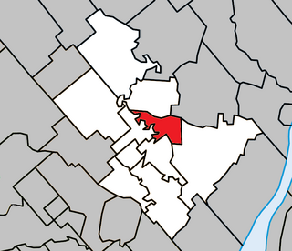
Sainte-Foy is a former city in central Quebec, Canada alongside the Saint Lawrence River. It was amalgamated into Quebec City at the start of 2002. Most of the formerly independent municipality of Sainte-Foy is located in the borough of Sainte-Foy–Sillery–Cap-Rouge — initially as one of the two constituent districts of the former borough of Sainte-Foy–Sillery. On 1 November 2009, Sainte-Foy was subdivided into four separate districts: Cité-Universitaire, Plateau, Saint-Louis, Pointe-de-Sainte-Foy, when the borough of Sainte-Foy–Sillery–Cap-Rouge was formed.
Roberval is a city on the south-western shore of Lac Saint-Jean in the Le Domaine-du-Roy Regional County Municipality of Quebec, Canada. With a population of 10,227 in the Canada 2011 Census, it is the fourth largest city on this lake after Alma, Dolbeau-Mistassini and Saint-Félicien. It is the seat of the Domaine-du-Roy RCM and the main service centre for the region with a hospital and some government services. It is also the seat of the judicial district of Roberval.

Wendake is the current name for an urban reserve of the Huron-Wendat Nation in the Canadian province of Quebec. It is an enclave entirely surrounded by the La Haute-Saint-Charles borough of Quebec City, within the former city of Loretteville. One of the Seven Nations of Canada, the settlement was formerly known as Village-des-Hurons, and also as (Jeune)-Lorette.
Capitale-Nationale is one of the 17 administrative regions of Quebec. It is anchored by the provincial capital, Quebec City, and is largely coextensive with that city's metropolitan area. It has a land area of 18,797.45 km2. It reported a total resident population of 729,997 as of the Canada 2016 Census, with Quebec City having 73.7 percent of the total.

Saint-Raymond, also called Saint-Raymond de Portneuf, is a city in Quebec, Canada, located about 63 kilometres (39 mi) north-west of Quebec City. It is the largest city in population and area of the Portneuf Regional County Municipality.
The 2000–2006 municipal reorganization in Quebec resulted in large-scale amalgamation (merging) of smaller municipalities in Quebec into larger cities. It was undertaken by one administration, and modified and partially undone by its successor.
Notre-Dame-des-Anges is a parish municipality in Quebec, Canada, home of the General Hospital of Quebec.
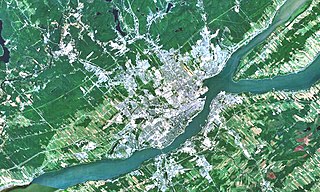
The Communauté métropolitaine de Québec (CMQ), or Quebec Metropolitan Community, is an administrative division of the province of Quebec, comprising the metropolitan area of Quebec City. The CMQ is one of the two metropolitan communities of Quebec.
The urban agglomeration of Quebec City is an urban agglomeration in Quebec. It may also be referred to as the urban agglomeration of the city of Québec.

Notre-Dame-de-Lorette is a municipality in the Canadian province of Quebec, located within the regional county municipality of Maria-Chapdelaine. With a population of 175 in the Canada 2006 Census, it is the least populated and northernmost municipality in the Saguenay–Lac-Saint-Jean region.
Pierre-Joseph-Marie Chaumonot was a French priest and Jesuit missionary who learned and documented the language of the Wyandot people, also known as the Huron. He studied at the Jesuits’ noviciate in Florence and, after three more years of training, came to Canada in 1639.
Quebec County was a historic county in the province of Quebec, Canada. The county included the Quebec City metropolitan area and extended northwestward. The county seat was Loretteville.

Notre-Dame-de-Montauban is a municipality in the Mauricie region in Canada. This municipality is located at the northern edge of regional county municipality of Mékinac Regional County Municipality and the administrative region of Mauricie. It includes the population centres of Notre-Dame-des-Anges and Montauban-les-Mines. Both communities are located along route 367, about 7 kilometres (4.3 mi) apart.

La Macaza is a municipality and village in the province of Quebec, Canada. The village is located in the Laurentian Mountains, in the Laurentian region, in Antoine-Labelle Regional County Municipality. Its population was 1053 in the Canada 2011 Census.

Portneuf is a municipality in the Portneuf Regional County Municipality, in the province of Quebec, Canada. It is located on the Saint Lawrence River, between Quebec City and Trois-Rivières. The Portneuf River runs on the east side of the town centre.
Notre-Dame-des-Prairies is a town in the Lanaudière region of Quebec, Canada, part of the Joliette Regional County Municipality. It is a suburb of Joliette, located along the eastern shores of the L'Assomption River.
Notre-Dame-des-Monts is a municipality in the Capitale-Nationale region of Quebec, Canada.

The Lorette River is a tributary of the Saint-Charles River, crossing the sector Sainte-Foy–Sillery–Cap-Rouge and the area of L'Ancienne-Lorette in Quebec City, in the administrative region of Capitale-Nationale, in the province of Quebec, Canada.