La Bouilladisse

Last updated

La Bouilladisse
Eglise la Bouilladisse, vue 2.jpg
Église de la Bouilladisse
Blason de la ville de La Bouilladisse (13).svg
Location of La Bouilladisse
La Bouilladisse
France location map-Regions and departements-2016.svg
Red pog.svg
La Bouilladisse
Provence-Alpes-Cotes d'Azur region location map.svg
Red pog.svg
La Bouilladisse
Coordinates: 43°23′43″N5°35′43″E / 43.3953°N 5.5953°E / 43.3953; 5.5953
Country France
Region Provence-Alpes-Côte d'Azur
Department Bouches-du-Rhône
Arrondissement Marseille
Canton Allauch
Intercommunality Aix-Marseille-Provence
Government
  Mayor (20202026) José Morales [1] (DVG)
Area
1
12.61 km2 (4.87 sq mi)
Population
 (2021) [2]
6,341
  Density500/km2 (1,300/sq mi)
Time zone UTC+01:00 (CET)
  Summer (DST) UTC+02:00 (CEST)
INSEE/Postal code
13016 /13720
Elevation193–686 m (633–2,251 ft)
1 French Land Register data, which excludes lakes, ponds, glaciers > 1 km2 (0.386 sq mi or 247 acres) and river estuaries.

La Bouilladisse (French pronunciation: [labujadis] ; Occitan : Bolhadissa) is a commune in the Bouches-du-Rhône department in the Provence-Alpes-Côte d'Azur region of Southern France.

Contents

Geography

A small residential town of forestry, farming and a little light industry situated in the valley of the small river Merlançon, some 14 miles (23 km) northeast of Marseille at the junction of the D8 with the D45e and D96 roads. The A52 autoroute skirts the south-western border of the commune's territory. In 2025, La Bouilladisse will be served by two stations of the Aubagne tramway after the northern extension of Line T is completed.

History

The commune was created on 6 July 1880 as La Bourine, when it was separated from the neighbouring village of Auriol. It adopted its current name on 20 January 1910. [3]

Population

Historical population
YearPop.±% p.a.
1881 1,378    
1886 1,315−0.93%
1891 1,304−0.17%
1896 1,236−1.07%
1901 1,329+1.46%
1906 1,410+1.19%
1911 1,332−1.13%
1921 1,243−0.69%
1926 1,521+4.12%
1931 1,575+0.70%
1936 1,400−2.33%
YearPop.±% p.a.
1946 1,507+0.74%
1954 1,601+0.76%
1962 1,715+0.86%
1968 1,959+2.24%
1975 2,231+1.87%
1982 3,117+4.89%
1990 4,115+3.53%
1999 4,904+1.97%
2007 5,652+1.79%
2012 6,022+1.28%
2017 6,194+0.56%
Source: EHESS [3] and INSEE (1968-2017) [4]

Sights

See also

Related Research Articles

<span class="mw-page-title-main">Bouches-du-Rhône</span> Department in Provence-Alpes-Côte dAzur, France

Bouches-du-Rhône is a department in southern France. It borders Vaucluse to the north, Gard to the west and Var to the east. The Mediterranean Sea lies to the south. Its prefecture and largest city is Marseille; other important cities include Aix-en-Provence, Arles, Martigues and Aubagne.

<span class="mw-page-title-main">Orgon</span> Commune in Provence-Alpes-Côte dAzur, France

Orgon is a commune in the Bouches-du-Rhône department in the Provence-Alpes-Côte d'Azur region in Southern France. It is located on the departmental border with Vaucluse, which follows the river Durance.

<span class="mw-page-title-main">Lamanon</span> Commune in Provence-Alpes-Côte dAzur, France

Lamanon is a commune located in the Bouches-du-Rhône department, part of the Provence-Alpes-Côte d'Azur region in southern France. Its inhabitants are called Lamanonais in French.

<span class="mw-page-title-main">Rousset, Bouches-du-Rhône</span> Commune in Provence-Alpes-Côte dAzur, France

Rousset is a commune in the Bouches-du-Rhône department in southern France close to Aix-en-Provence.

<span class="mw-page-title-main">Auriol, Bouches-du-Rhône</span> Commune in Provence-Alpes-Côte dAzur, France

Auriol is a commune in the Huveaune valley in the Bouches-du-Rhône department in the Provence-Alpes-Côte d'Azur region of Southern France. The commune has been awarded one flower by the National Council of Towns and Villages in Bloom in the Competition of cities and villages in Bloom. Located west of Roquevaire and northwest of Aubagne, it will be served by two stations of the Aubagne tramway when the northern Line T extension opens in 2023.

<span class="mw-page-title-main">Arrondissement of Marseille</span> Arrondissement in Provence-Alpes-Côte dAzur, France

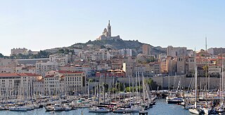
The arrondissement of Marseille is an arrondissement of France in the Bouches-du-Rhône department in the Provence-Alpes-Côte d'Azur region. It has 21 communes. Its population is 1,069,909 (2016), and its area is 683.2 km2 (263.8 sq mi).

<span class="mw-page-title-main">Bouc-Bel-Air</span> Commune in Provence-Alpes-Côte dAzur, France

Bouc-Bel-Air is a commune in the Bouches-du-Rhône department, Provence-Alpes-Côte d'Azur region in Southern France. It is situated between Aix-en-Provence to the north, Gardanne to the east, Marseille to the south and Vitrolles to the west. The old village is located at the summit of a small hill. In 2018, the commune had a population of 14,784.

<span class="mw-page-title-main">Peypin</span> Commune in Provence-Alpes-Côte dAzur, France

Peypin is a commune in the Bouches-du-Rhône department in the Provence-Alpes-Côte d'Azur region of France.

<span class="mw-page-title-main">La Penne-sur-Huveaune</span> Commune in Provence-Alpes-Côte dAzur, France

La Penne-sur-Huveaune is a commune east of Marseille and west of Aubagne along the A50 autoroute in the department of Bouches-du-Rhône in the Provence-Alpes-Côte d'Azur region in southern France.

<span class="mw-page-title-main">Roquefort-la-Bédoule</span> Commune in Provence-Alpes-Côte dAzur, France

Roquefort-la-Bédoule is a commune in the Bouches-du-Rhône department in the Provence-Alpes-Côte d'Azur region in Southern France. Its inhabitants are called Bédoulens (masculine) and Bédoulennes (feminine). In 2018, Roquefort-la-Bédoule had a population of 5,896.

La Destrousse is a commune in the department of Bouches-du-Rhône in the Provence-Alpes-Côte d'Azur region in southern France. The commune was created in 1870 from part of Peypin.

Ensuès-la-Redonne is a seaside commune in the Bouches-du-Rhône department in the Provence-Alpes-Côte-d'Azur region in Southern France. It is located on the Côte Bleue, 15 km (9.3 mi) west of Marseille, within the larger Aix-Marseille-Provence Metropolis.

<span class="mw-page-title-main">Éguilles</span> Commune in Provence-Alpes-Côte dAzur, France

Éguilles is a commune in the Bouches-du-Rhône department in southern France. It is halfway between Saint-Cannat and Aix-en-Provence.

<span class="mw-page-title-main">Coudoux</span> Commune in Provence-Alpes-Côte dAzur, France

Coudoux is a commune in the Bouches-du-Rhône department in southern France.

<span class="mw-page-title-main">La Fare-les-Oliviers</span> Commune in Provence-Alpes-Côte dAzur, France

La Fare-les-Oliviers is a commune in the Bouches-du-Rhône department in the Provence-Alpes-Côte d'Azur region in Southern France. Located in the Aix-Marseille-Provence Metropolis, it had a population of 8,666 in 2018.

<span class="mw-page-title-main">Gardanne</span> Commune in Provence-Alpes-Côte dAzur, France

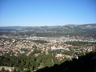
Gardanne is a commune in the Bouches-du-Rhône department in southern France. Its inhabitants are called Gardannais.

<span class="mw-page-title-main">Gignac-la-Nerthe</span> Commune in Provence-Alpes-Côte dAzur, France

Gignac-la-Nerthe is a commune in the Bouches-du-Rhône department in southern France. It is located about 10 km north-north-west of Marseille and is primarily a residential community.

<span class="mw-page-title-main">Châteauneuf-le-Rouge</span> Commune in Provence-Alpes-Côte dAzur, France

Châteauneuf-le-Rouge is a commune in the Bouches-du-Rhône department in southern France.

<span class="mw-page-title-main">Alleins</span> Commune in Provence-Alpes-Côte dAzur, France

Alleins is a commune in the Bouches-du-Rhône department in the Provence-Alpes-Côte d'Azur region of southern France.

<span class="mw-page-title-main">La Roque-d'Anthéron</span> Commune in Provence-Alpes-Côte dAzur, France

La Roque-d'Anthéron is a commune in the Bouches-du-Rhône department in the Provence-Alpes-Côte d'Azur region in Southern France. Part of the Aix-Marseille-Provence Metropolis, it is located on the departmental border with Vaucluse. In 2018, La Roque-d'Anthéron had a population of 5,441. Silvacane Abbey, a former Cistercian monastery founded in 1144 by monks from Morimond Abbey, is located in La Roque-d'Anthéron, east of the town centre.

References

  1. "Répertoire national des élus: les maires" (in French). data.gouv.fr, Plateforme ouverte des données publiques françaises. 13 September 2022.
  2. "Populations légales 2021". The National Institute of Statistics and Economic Studies. 28 December 2023.
  3. 1 2 Des villages de Cassini aux communes d'aujourd'hui: Commune data sheet La Bouilladisse, EHESS (in French).
  4. Population en historique depuis 1968, INSEE