La Chapelle-Huon

Last updated

La Chapelle-Huon
Chapelle-Huon - Vue ensemble.jpg
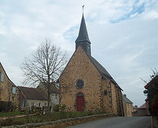
A general view of La Chapelle-Huon
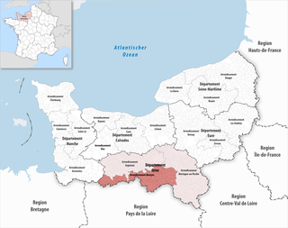
Location of La Chapelle-Huon
La Chapelle-Huon
France location map-Regions and departements-2016.svg
Red pog.svg
La Chapelle-Huon
Pays de la Loire region location map.svg
Red pog.svg
La Chapelle-Huon
Coordinates: 47°51′22″N0°44′25″E / 47.856°N 0.7403°E / 47.856; 0.7403 Coordinates: 47°51′22″N0°44′25″E / 47.856°N 0.7403°E / 47.856; 0.7403
Country France
Region Pays de la Loire
Department Sarthe
Arrondissement Mamers
Canton Saint-Calais
Intercommunality Vallées de la Braye et de l'Anille
Government
  Mayor (20202026) Philippe Lebert [1]
Area
1
18.7 km2 (7.2 sq mi)
Population
 (Jan. 2018) [2]
538
  Density29/km2 (75/sq mi)
Demonym(s) Capellhuonnais, Capellhuonnaise
Time zone UTC+01:00 (CET)
  Summer (DST) UTC+02:00 (CEST)
INSEE/Postal code
72064 /72310
1 French Land Register data, which excludes lakes, ponds, glaciers > 1 km2 (0.386 sq mi or 247 acres) and river estuaries.

La Chapelle-Huon is a commune in the Sarthe department in the Pays de la Loire region in north-western France. La Chapelle-Huon (Latin Capella Hugonie) is named after one of its ancient lords, named Hugo. His name appears for the first time in 1233 under the name of Capella Parrochia Hugonie. Its inhabitants are called Capellhuonnais and Capellhuonnaises. It is located 7.5 km from Saint-Calais and 44 miles from Le Mans, and once depended on the deanery of Saint-Calais, the Archdeaconry of Montfort, and the diocese of Le Mans. It is in the department of Sarthe, which is since 1790 the eastern part of the former province of Maine. This town is bounded on the north by Saint-Gervais-de-Vic, on the east by Savigny-sur-Braye, south by Besse-sur-Braye, and west by Cogners . Egg-shaped, it extends the SSO NO. The village forms several small streets north of the church, and a row of houses to the west.[ citation needed ]

See also

Related Research Articles

Communes of the Sarthe department

The following is a list of the 354 communes of the Sarthe department of France.

Arrondissements of the Sarthe department

The 3 arrondissements of the Sarthe department are:

  1. Arrondissement of La Flèche, with 118 communes. The population of the arrondissement was 152,008 in 2016.
  2. Arrondissement of Mamers, with 191 communes. The population of the arrondissement was 150,238 in 2016.
  3. Arrondissement of Le Mans, with 45 communes. The population of the arrondissement was 265,315 in 2016.
Arrondissement of Vendôme Arrondissement in Centre-Val de Loire, France

The arrondissement of Vendôme is an arrondissement of France in the Loir-et-Cher departement in the Centre-Val de Loire region. It has 100 communes. Its population is 69,819 (2016), and its area is 1,722.3 km2 (665.0 sq mi).

Arrondissement of Alençon Arrondissement in Normandy, France

The arrondissement of Alençon is an arrondissement of France in the Orne department in the Normandy region. It has 111 communes. Its population is 86,907 (2016), and its area is 1,548.5 km2 (597.9 sq mi).

Arrondissement of Mayenne Arrondissement in Pays de la Loire, France

The arrondissement of Mayenne is an arrondissement of France in the Mayenne department in the Pays de la Loire region. It has 132 communes. Its population is 120,982 (2016), and its area is 2,961.8 km2 (1,143.6 sq mi).

Arrondissement of La Flèche Arrondissement in Pays de la Loire, France

The arrondissement of La Flèche is an arrondissement of France in the Sarthe department in the Pays de la Loire region. It has 118 communes. Its population is 152,008 (2016), and its area is 2,521.4 km2 (973.5 sq mi).

Arrondissement of Mamers Arrondissement in Pays de la Loire, France

The arrondissement of Mamers is an arrondissement of France in the Sarthe department in the Pays de la Loire region. It has 191 communes. Its population is 150,238 (2016), and its area is 2,904.9 km2 (1,121.6 sq mi).

Arrondissement of Le Mans Arrondissement in Pays de la Loire, France

The arrondissement of Le Mans is an arrondissement of France in the Sarthe department in the Pays de la Loire region. It has 45 communes. Its population is 262,997 (2016), and its area is 779.7 km2 (301.0 sq mi).

Couture-sur-Loir Part of Vallée-de-Ronsard in Centre-Val de Loire, France

Couture-sur-Loir is a former commune in the Loir-et-Cher department of central France. On 1 January 2019, it was merged into the new commune Vallée-de-Ronsard.

Saint-Calais Commune in Pays de la Loire, France

Saint-Calais is a commune in the Sarthe department in the region of Pays de la Loire in north-western France.

Sargé-sur-Braye Commune in Centre-Val de Loire, France

Sargé-sur-Braye is a commune in the Loir-et-Cher department in central France.

Bessé-sur-Braye Commune in Pays de la Loire, France

Bessé-sur-Braye is a commune in the Sarthe department in the region of Pays de la Loire in north-western France.

Marolles-lès-Saint-Calais Commune in Pays de la Loire, France

Marolles-lès-Saint-Calais is a commune in the Sarthe department in the region of Pays de la Loire in north-western France.

La Chapelle-Saint-Aubin Commune in Pays de la Loire, France

La Chapelle-Saint-Aubin is a commune in the Sarthe department in the Pays de la Loire region in north-western France.

La Chapelle-Saint-Fray Commune in Pays de la Loire, France

La Chapelle-Saint-Fray is a commune in the Sarthe department in the Pays de la Loire region in north-western France.

La Chapelle-Saint-Rémy Commune in Pays de la Loire, France

La Chapelle-Saint-Rémy is a commune in the Sarthe department in the Pays de la Loire region in north-western France.

Vibraye Commune in Pays de la Loire, France

Vibraye is a commune in the Sarthe department in the region of Pays de la Loire in north-western France.

Normandie-Maine Regional Natural Park

Normandie-Maine Regional Natural Park is a protected area of forest and bocage located in the French regions of Normandy and Pays de la Loire.

The canton of Le Perche is an administrative division of the Loir-et-Cher department, central France. It was created at the French canton reorganisation which came into effect in March 2015. Its seat is in Savigny-sur-Braye.

The canton of Saint-Calais is an administrative division of the Sarthe department, northwestern France. Its borders were modified at the French canton reorganisation which came into effect in March 2015. Its seat is in Saint-Calais.

References

  1. "Répertoire national des élus: les maires". data.gouv.fr, Plateforme ouverte des données publiques françaises (in French). 2 December 2020.
  2. "Populations légales 2018". INSEE. 28 December 2020.