La Creusille Harbor

Last updated
La Creusille Harbor
Blois 20.jpg
Traditional boat of Blois
La Creusille Harbor
Click on the map for a fullscreen view
Location
Country France
Location Centre-Val de Loire, Loir-et-Cher, Blois
Coordinates 47°35′13″N1°20′42″E / 47.58689°N 1.34495°E / 47.58689; 1.34495
Details
Opened17st century

La Creusille is a harbor on the left bank of the Loire river, located in the southern part of Blois , France.

Contents

Meaning

The word Creusille (French pronunciation: [kʁøzij] ) is an old local dialect term to designate the “hollow pilgrim's scallop” (« creuse coquille du pèlerin » in French [1] ). This refers to the shell of Saint James Christian pilgrims used to wear when going to Santiago de Compostela, Spain. [2]

History

Since the Ancient times, the Loire river is the major axis in the region for transportation, and its stream bed made the Val de Loire agricultural. Due to its strategical situation, Blois is an obligatory passage for all pilgrims who follow the Way of St James through the Tours Route (on the Via Turonensis starting in Paris and passing through Tours). [3] The flows of people and goods are thus constant, and justify the development of rudimentary strikes at several points of the banks of the river.

During the Middle Ages, the river is rather different than today. Indeed, the medieval bridge was covered with houses, towers, and even a chapel. To feed 5 water mills, a 650m-long submersible dike was built in the middle of the river around the 9th century (at the latest). [4]

Until 1606, both banks of the river were not parts of the same city, Blois. Indeed, the city was originally set up on the right bank. On the other side, this was actually a river island with a different manor that was under the Catholic Church's administration through St Saturnin parish. The island was named Insula Evenna, and the village standing there Vienne. As such, La Creusille has always been part of Vienne. Until this moment, Blois had its own harbor but it was abandoned after the addition of Vienne. [5]

From the 17th century on, market gardening, river transportation, fishing, tanning, and the hotel business flourished, and their growth exceeded the capacity of the shoreline. Thus, a lean port with two access ramps to the shore was developed.

After the fall of the medieval bridge in 1716, the port was reinforced as part of the reconstructions of the Loire levees and the construction of the new Jacques-Gabriel Bridge. All the remaining water mills were destroyed, but the submersible dike was readjusted in order to divert the river's flow to the right bank and thus away from La Creusille, making it easier to moor boats. In 1717, a dike was built in the extension of the harbor and towards the East: the operation dried up the La Bouillie river channel and thus linked the former Evenna island to the left bank. [6]

The arrival of the railroad in Blois in 1846 led the port to reinvent itself. Now that goods and people could reach Paris in a few hours (as opposed to several days by boat, the duration of which could vary according to direction, season, weather...), La Creusille gradually became a shipyard. [7]

At the same time, a new activity appeared in the 19th century: sand mining. Miners extracted sand and gravel directly from the steam bed of the Loire river, but the practice was sufficiently important to lower the water line, lower the alluvial water table, dry out wetlands and cause pike spawning grounds to disappear. Mining in Blois was therefore naturally abolished in 1995. [8]

Traditional boats

Today's La Creusille

Since the year 2000, La Creusille is part of the UNESCO's World Heritage sites in France. [9]

Today, the port has given way to an urban park on the left bank of the Loire river, complete with a leisure area. Accessible by car, the park has a parking area, a playground, picnic areas, a ping-pong table, a self-service library and a boulodrome, and provides free access to drinking water and electricity. [10]

The park is located on the route of La Loire à vélo and the European Rivers Route (EV6). [11]

Since 2010, a guinguette animates the park in summer. [12]

La Creusille also hosts the Loire Observatory, which offers traditional boat trips on the river. [13]

Related Research Articles

<span class="mw-page-title-main">Orléans</span> Prefecture and commune in France

Orléans is a city in north-central France, about 120 kilometres southwest of Paris. It is the prefecture of the department of Loiret and of the region of Centre-Val de Loire.

<span class="mw-page-title-main">Loir-et-Cher</span> Department of France

Loir-et-Cher is a department in the Centre-Val de Loire region of France. Its name is originated from two rivers which cross it, the Loir in its northern part and the Cher in its southern part. Its prefecture is Blois. The INSEE and La Poste gave it the number 41. It had a population of 329,470 in 2019.

<span class="mw-page-title-main">Indre</span> Department of France

Indre ; is a department in central France named after the river Indre. The inhabitants of the department are known as the Indriens and Indriennes. Indre is part of the current administrative region of Centre-Val de Loire. The region is bordered by the departments of Indre-et-Loire to the west, Loir-et-Cher to the north, Cher to the east, Creuse, and Haute-Vienne to the south, and Vienne to the southwest. The préfecture (capital) is Châteauroux and there are three subpréfectures at Le Blanc, La Châtre and Issoudun. It had a population of 219,316 in 2019.

<span class="mw-page-title-main">Blois</span> Prefecture and commune in Centre-Val de Loire, France

Blois is a commune and the capital city of Loir-et-Cher department, in Centre-Val de Loire, France, on the banks of the lower Loire river between Orléans and Tours.

<span class="mw-page-title-main">Vienne (river)</span> River in France

The Vienne is a major river in south-western France. It is 363 km (226 mi) long. It is a significant left tributary of the lower Loire. It supports numerous hydroelectric dams, and it is the main river of the northern part of the Nouvelle-Aquitaine region.

<span class="mw-page-title-main">Chalon-sur-Saône</span> Subprefecture and commune in Bourgogne-Franche-Comté, France

Chalon-sur-Saône is a city in the Saône-et-Loire department in the region of Bourgogne-Franche-Comté in eastern France.

<span class="mw-page-title-main">Yzeures-sur-Creuse</span> Commune in Centre-Val de Loire, France

Yzeures-sur-Creuse is a commune in the Indre-et-Loire department, central France.

<span class="mw-page-title-main">Descartes, Indre-et-Loire</span> Commune in Centre-Val de Loire, France

Descartes is a large village and commune in the Indre-et-Loire department in central France. It is approximately 29 kilometers east of Richelieu and about 48 kilometers east of Loudun, on the banks of the Creuse River, near the border of the French department of Vienne, and the border of the region between Centre-Val de Loire and Nouvelle-Aquitaine. It is famous for the birthplace of the French mathematician and philosopher who invented the Cartesian coordinate system, René Descartes.

<span class="mw-page-title-main">Montsoreau</span> Commune in Pays de la Loire, France

Montsoreau is a commune of the Loire Valley in the Maine-et-Loire department in western France on the Loire, 160 km (99 mi) from the Atlantic coast and 250 km (160 mi) from Paris. The village is listed among The Most Beautiful Villages of France and is part of the Loire Valley UNESCO World Heritage Site.

<span class="mw-page-title-main">Route nationale 7</span> Road in France

The Route nationale 7, or RN 7, is a trunk road (nationale) in France between Paris and the border with Italy. It was also known as Route des vacances, Route bleue, and — sarcastically, during the annual rush to the Mediterranean beaches — the Route de la mort.

Ports-sur-Vienne is a commune in the Indre-et-Loire department in central France.

<span class="mw-page-title-main">Navibus</span>

Navibus is a group of water bus routes in the French city of Nantes, operated as part of the Tan urban transit network that also includes buses and trams. Routes operate on both the River Loire and the River Erdre, and accept the full range of standard Tan tickets.

<span class="mw-page-title-main">Vienne</span> Department of France

Vienne is a landlocked department in the French region of Nouvelle-Aquitaine. It takes its name from the river Vienne. It had a population of 438,435 in 2019.

<span class="mw-page-title-main">Paris–Bordeaux railway</span>

The railway from Paris to Bordeaux is an important French 584-kilometre long railway line, that connects Paris to the southwestern port city Bordeaux via Orléans and Tours. The railway was opened in several stages between 1840 and 1853, when the section from Poitiers to Angoulême was finished. The opening of the LGV Atlantique high speed line from Paris to Tours in 1989 has decreased the importance of this section of the line for passenger traffic; the opening of the LGV Sud Europe Atlantique in 2017 has seen all long distance passenger trains migrating to that line and leaving space for more regional and local trains, as well as freight trains.

<span class="mw-page-title-main">Loire</span> Longest river in France

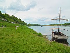
The Loire is the longest river in France and the 171st longest in the world. With a length of 1,006 kilometres (625 mi), it drains 117,054 km2 (45,195 sq mi), more than a fifth of France's land, while its average discharge is only half that of the Rhône.

<span class="mw-page-title-main">Nouvelle-Aquitaine</span> Administrative region of France

Nouvelle-Aquitaine is the largest administrative region in France, spanning the west and southwest of Metropolitan France. The region was created in 2014 by the merging of Aquitaine, Limousin, and Poitou-Charentes in a territorial reform. Nouvelle-Aquitaine has an area of 84,035.7 km2 (32,446.4 sq mi) – more than 17 of Metropolitan France – and has a population of 6,033,952 as of 2020. The new region was established on 1 January 2016, following the regional elections in December 2015.

<span class="mw-page-title-main">Canal de Haute Perche</span> River in Loire-Atlantique, France

The Haute Perche Canal, despite its title, is a natural river, the Rivière de Haute-Perche, that has been slightly canalised to improve navigation between its mouth in the Bay of Bourgneuf at the port town of Pornic and the upstream settlements of Le Clion-sur-Mer, Chauvé and Arthon-en-Retz. It is located in the Pays de Retz in the Loire-Atlantique department and the Pays de la Loire region. It has also been known as the Canal de Pornic since the 16th century and was sometimes called the Étier de Haute Perche. Historically, it was called the Rouet, after the wheels of the water mills in the port.

<span class="mw-page-title-main">Blois-Vienne</span> Borough of Blois in Centre-Val de Loire, France

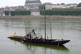
Blois-Vienne, or merely Vienne for locals, is the common name given to the southern part of Blois, central France, separated from the rest of the city by the natural border of the Loire river. It corresponds to the subdistricts of St Saturnin, La Creusille, Les Métairies and La Vaquerie, but also include the hamlets of Bas-Rivière and Béjun, although these ones are now administratively attached to the neighboring commune of Chailles. In other words, it is now the left bank of the Loire in Blois.

<span class="mw-page-title-main">Blois-Vienne Church</span> Catholic church in Loir-et-Cher, in France

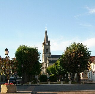
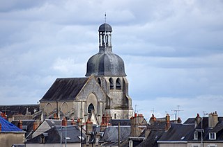
Blois-Vienne Church is a Roman Catholic church located on the left bank of the Loire river in the city of Blois, France.

References

  1. Adrien Thibault (1892). Glossaire du pays blaisois (in French). ISBN   2842653122..
  2. Guénon, René (2004). Studies in Freemasonry and the Compagnonnage. Sophia Perennis. p. 60. ISBN   978-0-900-58888-4.
  3. On the Blois City Official Website (2022). "La Creusille Harbour". blois.fr.
  4. Institut National de Recherches Archéologiques Préventives (INRAP) (2014). Archéologie en Région Centre : Vivre au bord de l'eau à Blois (in French).
  5. Institut National de Recherches Archéologiques Préventives (INRAP) (2014). Archéologie en Région Centre : Vivre au bord de l'eau à Blois (in French).
  6. Georges Touchard-Lafosse (2011). Histoire de Blois et de son territoire, depuis les temps les plus reculés jusqu'à nos jours (in French).
  7. Noëlle Lizé, Emmanuelle Plumet and Johanne Quéméré (2017). Focus sur Blois : quartier Vienne (PDF) (in French).
  8. Noëlle Lizé, Emmanuelle Plumet and Johanne Quéméré (2017). Focus sur Blois : quartier Vienne (PDF) (in French).
  9. On the Blois City Official Website (2022). "La Creusille Harbour". blois.fr.
  10. On the Blois City Official Website (2022). "La Creusille Harbour". blois.fr.
  11. On the Blois City Official Website (2022). "La Creusille Harbour". blois.fr.
  12. On the Blois City Official Website (2022). "La Creusille Harbour". blois.fr.
  13. On the Blois City Official Website (2022). "La Creusille Harbour". blois.fr.